Downscaling compensation technique for satellite precipitation data

A correction method and downscaling technology, applied in the field of satellite measurement of precipitation data processing, can solve problems such as low resolution of satellite precipitation data

Active Publication Date: 2017-05-31
HOHAI UNIV
View PDF6 Cites 34 Cited by
  • Summary
  • Abstract
  • Description
  • Claims
  • Application Information

AI Technical Summary

Problems solved by technology

[0005] The purpose of the present invention is to solve the problem of low resolution of satellite precip

Method used


Image

  • Downscaling compensation technique for satellite precipitation data

Examples


Embodiment 1

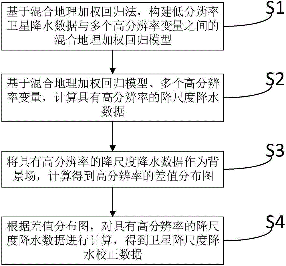
[0032] Such as figure 1 As shown, a downscaling correction method for satellite precipitation data, the method includes:

[0033] S1, based on the hybrid geographic weighted regression method, construct a hybrid geographic weighted regression model between low-resolution satellite precipitation data and multiple high-resolution variables. Multiple high-resolution variables are: annual normalized difference vegetation index, surface temperature, elevation, slope, aspect, longitude, and latitude.

[0034] In the present invention, the spatial resolution range of the low resolution is 10-30km; the spatial resolution range of the high resolution is 0.5-4km. In this embodiment, the low resolution is a spatial resolution of 27 km; the high resolution is a spatial resolution of 1 km.

[0035] S2, based on a mixed geographically weighted regression model and multiple high-resolution variables, calculate downscaled precipitation data with high resolution.

[0036] S3, the high-resol...

Embodiment 2

[0040] Such as figure 1As shown, a downscaling correction method for satellite precipitation data, the method includes:

[0041] S1, based on the hybrid geographic weighted regression method, construct a hybrid geographic weighted regression model between low-resolution satellite precipitation data and multiple high-resolution variables. Multiple high-resolution variables are: annual normalized difference vegetation index (Normalized Difference Vegetation Index, NDVI for short), surface temperature, elevation, slope, aspect, longitude, and latitude.

[0042] In this embodiment, all low-resolution satellite precipitation data of a certain year are accumulated and calculated to obtain annual-scale low-resolution satellite precipitation data.

[0043] In the present invention, the spatial resolution range of the low resolution is 10-30km; the spatial resolution range of the high resolution is 0.5-4km. In this embodiment, the low resolution is a spatial resolution of 27 km; the ...


PUM


Abstract

The invention discloses a downscaling compensation technique for satellite precipitation data. Firstly, based on a mixed geographically weighted regression method, a mixed geographically weighted regression between low resolution satellite precipitation data and multiple high resolution variables is constructed. Secondly, based on the mixed geographically weighted regression and multiple high resolution variables, the downscaling precipitation data with high resolution is calculated. Thirdly, regarding the downscaling precipitation data with high resolution as an ambient field, a difference value distribution diagram with high resolution is acquired by calculating. Lastly, according to the difference value distribution diagram, the downscaling precipitation data with high resolution is calculated and the satellite downscaling precipitation compensation data is acquired. The downscaling compensation technique for satellite precipitation data is capable of obtaining high-precision satellite precipitation data with high resolution and being applied to the calculation of meteorological drought index and a driving hydrological model and providing high-precision input data for the hydrological model.

Description

technical field [0001] The invention relates to satellite-measured precipitation data processing technology, in particular to a downscale correction method acting on satellite precipitation data. Background technique [0002] Precipitation is a key climate element in the global water and energy cycle. The occurrence of precipitation is affected by many factors and has strong temporal and spatial changes. Before the advent of meteorological satellites, the measurement of rainfall was mainly done by ground-based rain gauges. The rain gauge measurement method has high accuracy for a single point, but it cannot reflect the precipitation distribution on a large spatial scale. Since the advent of meteorological satellites in the 1960s, the use of remote sensing to track and analyze weather systems at various scales and estimate precipitation has been greatly developed. Due to its wide coverage and relatively continuous observations in time and space, it can supplement the preci...

Claims


Application Information

Patent Timeline
IPC IPC(8): G06F17/18
CPCG06F17/18
Inventor 何祺胜刘宝柱周思张铁勤
Owner HOHAI UNIV
Why Eureka
Try Eureka