Batch computation method and device for geographic position distances

A geographical location and calculation method technology, applied in the LBS field, can solve problems such as large resource consumption and difficulty in achieving efficient processing by cluster computing solutions, and achieve the effects of improving processing speed, reducing distance calculations, and reducing data skew

Active Publication Date: 2017-06-23
ADVANCED NEW TECH CO LTD
View PDF4 Cites 6 Cited by
  • Summary
  • Abstract
  • Description
  • Claims
  • Application Information

AI Technical Summary

Problems solved by technology

This method can theoretically calculate the distance between point pairs at any position. However, in practical applications, if A and B contain a large amount of data, the Cartesian product operation will consume a lot of resources

Method used


Image

  • Batch computation method and device for geographic position distances
  • Batch computation method and device for geographic position distances

Examples


Embodiment Construction

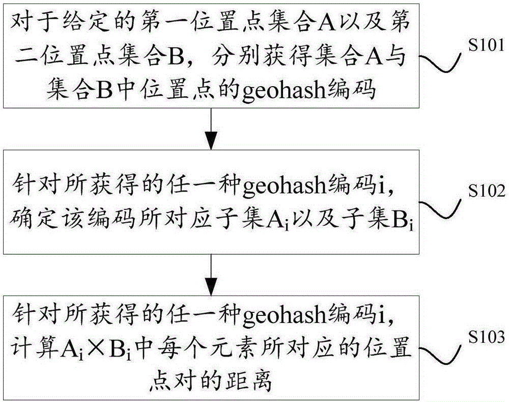
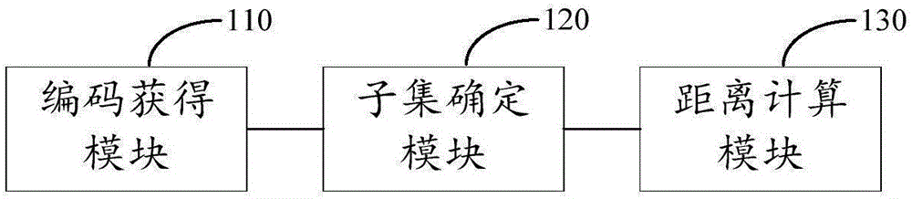
[0018] In order to enable those skilled in the art to better understand the technical solutions in the present application, the technical solutions in the embodiments of the present application will be described in detail below in conjunction with the drawings in the embodiments of the present application. Obviously, the described embodiments are only It is a part of the embodiments of this application, not all of them. All other embodiments obtained by persons of ordinary skill in the art based on the embodiments in this application shall fall within the protection scope of this application.

[0019] First, some related concepts involved in this application are introduced:

[0020] Geohash is a coding method for geographic location information, which can convert two-dimensional longitude and latitude into a string. Each geohash code represents not a point, but a rectangular area. In other words, geohash divides a large geographical area into several rectangular areas, and e...


PUM


Abstract

The invention discloses a batch computation method and device for geographic position distances. The batch computation method for geographic position distances comprises the following steps of for a given first position point set A and a given second position point set B, respectively obtaining geohash codes of position points in the set A and the set B; aiming at any obtained geohash code i, determining a subset Ai formed by position points, corresponding to the code, in the set A and determining a subset Bi formed by position points, corresponding to the code, in the set B; and aiming at the obtained geohash code i, computing a distance of a position point pair corresponding to each element in Ai*Bi. According to the method and device disclosed by the invention, the unnecessary position point pair distance computation can be decreased and the processing speed can be enhanced; and the method and device can be effectively suitable for distributed processing environment.

Description

technical field [0001] The present application relates to the technical field of LBS, and in particular to a method and device for batch calculation of geographic location distances. Background technique [0002] In LBS (Location Based Service, location-based service) related technologies, a common requirement is: given multiple geographic locations, calculate the distance between any two of them in batches, so as to provide further information based on the calculation results. services. For example, given the location point set A of a known merchant and the location point set B of an ordinary consumer user, it is necessary to calculate the distance between any "merchant-user", and then sort and filter according to the calculation results, and provide users with "nearby Merchant" information push. [0003] In order to realize the above requirements, the implementation scheme of the prior art is to calculate the Cartesian product of set A and set B (expressed as A×B), each ...

Claims


Application Information

Patent Timeline
IPC IPC(8): G06F19/00
CPCG16Z99/00
Inventor 张依娜
Owner ADVANCED NEW TECH CO LTD
Why Eureka
Try Eureka