Optimal attitude maneuver planning method for agile satellite zero-bias drift angle imaging

An attitude maneuvering and satellite technology, applied in the direction of attitude control, etc., can solve the problems of cumbersome planning process and large amount of calculation, and achieve the effect of avoiding coordinate system transformation and complicated drift angle calculation, and facilitating attitude closed-loop control

Active Publication Date: 2017-06-30
ZHEJIANG UNIV
View PDF3 Cites 13 Cited by
  • Summary
  • Abstract
  • Description
  • Claims
  • Application Information

AI Technical Summary

Problems solved by technology

The existing attitude maneuver planning methods generally have the defects of cumbersome planning process and large amount of calculation, and there is still a need for improvement and room for improvement
In addition, for the time mapping relationship between the target push-broom strip and the imaging orbit segment, the existing planning schemes all use a uniformly dis

Method used


Image

  • Optimal attitude maneuver planning method for agile satellite zero-bias drift angle imaging
  • Optimal attitude maneuver planning method for agile satellite zero-bias drift angle imaging
  • Optimal attitude maneuver planning method for agile satellite zero-bias drift angle imaging

Examples


Embodiment Construction

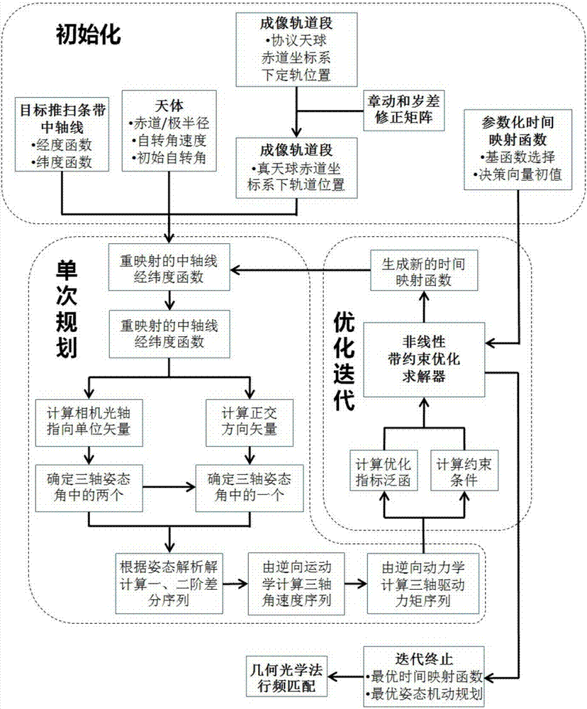
[0030] Such as figure 1 As shown, the optimal attitude maneuver planning method for agile satellite zero drift angle imaging according to the present invention, its specific steps are as follows:

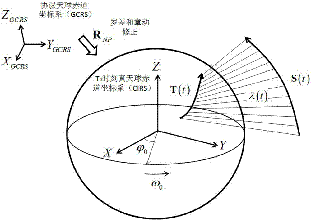
[0031] 1 Method initialization is the preparation phase of the planning method. For reflecting the versatility of the present invention, the equatorial radius of celestial reference ellipsoid model is R E , the pole radius is R Z , given imaging task time t∈[0,t f ], and the corresponding true sidereal time when t=0 is T 0 ,Such as figure 2 Shown:

[0032] 1.1 This method is calculated based on CIRS. Remember T 0 The precession and nutation transformation matrix from GCRS to CIRS at time is R NP (T 0 ), and considered to be time-invariant in a short imaging period, the satellite imaging orbit segment is recorded as S(t)=[x S the y S z S ] T . For example, in ground imaging, GCRS can be the J2000 coordinate system, and the corresponding orbit determination position i...


PUM


Abstract

The invention discloses an optimal attitude maneuver planning method for agile satellite zero-bias drift angle imaging. The method comprises two parts: single planning and iteration optimizing. In the single planning part, the time mapping function is substituted into the axis parameter equation of any target sweep band. Then, two attitude angles are determined by using the tracking constraint, and an attitude angle is determined by orthogonal constraint to further calculate the angular velocity and driving torque sequence. In the iteration optimizing part, the parameter set of the time mapping function is used as the decision vectors, the index function of the single planning result is calculated, the general optimization solver is called to search the optimal solution, and the geometric optics method is used for the horizontal scanning frequency matching of the optimal attitude maneuver. The invention uses the geometrical relation to determine the three-axis attitude maneuver of a satellite to any target sweep band TDI push imaging with the zero-bias angle as the known condition, which avoids the transformation of a series of coordinate systems and the calculation of complex drift angle in a traditional method, and based on this, time mapping optimization is realized, so that the expected maneuver cost in the imaging process becomes the smallest possible.

Description

technical field [0001] The invention relates to a general attitude maneuver planning method for agile optical satellites to perform TDI push-broom imaging on any target on the surface of a celestial body, especially one that can meet the requirement that the drift angle of the central pixel of the line array is strictly zero and minimize the expected attitude maneuver cost planning method. Background technique [0002] With the gradual expansion of the application of optical remote sensing satellites, agile and mobile imaging capabilities have become one of the important technical conditions for improving imaging effects. By enabling the satellite platform to have a wide range of rapid and precise attitude maneuvering capabilities, it can meet the needs of diverse imaging tasks. However, how to complete the push-broom imaging of the target strip within the allowed range of motion state constraints still needs to use the previous attitude maneuver planning as a reference. ...

Claims


Application Information

Patent Timeline
IPC IPC(8): G05D1/08
Inventor 邱炜许超
Owner ZHEJIANG UNIV
Why Eureka
Try Eureka