Visual sense simultaneous localization and mapping method based on dot and line integrated features

A technology that integrates features and positioning methods. It is used in instruments, character and pattern recognition, computer components, etc. It can solve the problems of high robustness, time-consuming, and environmental dependence, and achieve good clustering effect.

Active Publication Date: 2017-06-30
ZHEJIANG UNIV
View PDF6 Cites 68 Cited by
  • Summary
  • Abstract
  • Description
  • Claims
  • Application Information

AI Technical Summary

Problems solved by technology

However, point features are highly dependent on the environment, and high-quality

Method used


Image

  • Visual sense simultaneous localization and mapping method based on dot and line integrated features
  • Visual sense simultaneous localization and mapping method based on dot and line integrated features
  • Visual sense simultaneous localization and mapping method based on dot and line integrated features

Examples


Embodiment Construction

[0039] In order to better understand the technical solution of the present invention, further description will be made below in conjunction with the accompanying drawings.

[0040] Using the clustering method to build a visual dictionary offline, determine the inverse text frequency (IDF) of the node:

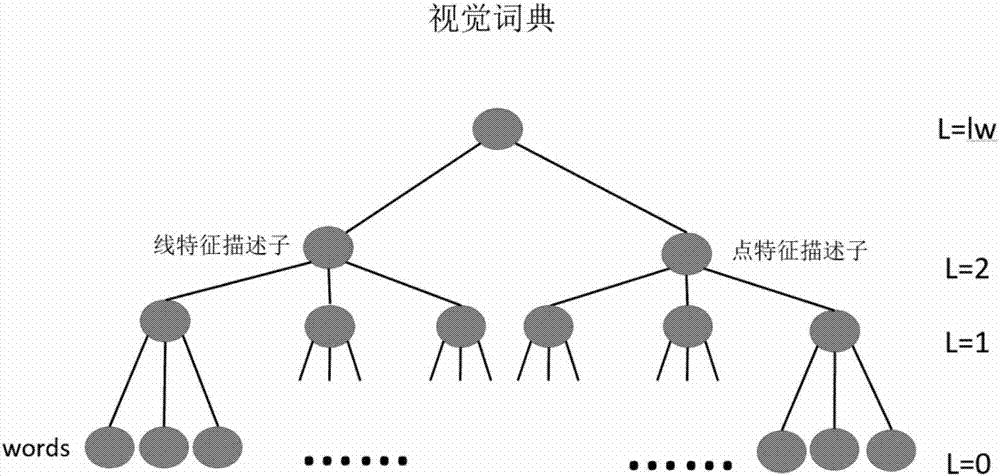
[0041] In order to judge whether the camera has repeatedly visited the same area, the features contained in each frame image itself are converted into visual vocabulary. These visual vocabularies correspond to a discretized description subspace—called a visual lexicon. like figure 1 As shown, a large number of feature descriptors are used to build a tree-like dictionary offline, and the feature descriptors are extracted from a large number of training image sets. The process of building a tree-like dictionary is also a process of clustering with the Kmeans++ algorithm. The descriptors here are ORB point feature descriptors and LBD line feature descriptors. Since they are a...


PUM


Abstract

The invention discloses a visual sense simultaneous localization and mapping method based on dot and line integrated features. The method comprehensively utilizes the line features and the dot features extracted and obtained from a binocular camera image and is able to be used for the positioning and the attitude estimation of a robot in both an external environment and an internal environment. As the dot features and the line features are integrated for use, the system becomes more robust and more accurate. For the parameterization of linear features, the Pluck coordinates are used for straight line calculations, including geometric transformations, 3D reconstructions, and etc. In the back-end optimization, the orthogonal representation of the straight line is used to minimize the number of the parameters of the straight line. The off-line established visual dictionary for the dot and line integrated features is used for closed loop detections; and through the method of adding zone bits, the dot characteristics and the line characteristics are treated differently in the visual dictionary and when an image database is created and image similarity is calculated. The invention can be applied to the construction of a scene image both indoors and outdoors. The constructed map integrates the feature dots and the feature lines, therefore, able to provide even richer information.

Description

technical field [0001] The present invention relates to the technical field of visual simultaneous mapping and positioning, in particular to the technical field of feature-based binocular vision SLAM (simultaneous positioning and mapping). Background technique [0002] For visual simultaneous modeling and positioning technology, keyframe-based optimization and graph optimization have become the mainstream framework for visual SLAM problems. Graph optimization techniques have been shown to outperform traditional filtering frameworks in terms of computational resources consumed and consistency of results. Point features are the most widely used features in visual simultaneous mapping and positioning technology. They are particularly rich in indoor and outdoor environments, easy to be tracked in continuous image sequences, and easy to calculate in geometric transformations. However, point features are highly dependent on the environment, and high-quality point features require...

Claims


Application Information

Patent Timeline
IPC IPC(8): G06K9/00G06K9/32G06K9/46
CPCG06V20/10G06V10/255G06V10/44
Inventor 刘勇左星星
Owner ZHEJIANG UNIV
Why Eureka
Try Eureka