Fire boundary vector information real-time extraction and visualization method and system

A technology of boundary vector and boundary information, applied in image data processing, instruments, calculations, etc., can solve the problems of high altitude, wide forest area, lack of good response plan and technical processing, etc., to achieve small transmission data and data structure. simple effect

Active Publication Date: 2017-07-28
FUZHOU UNIV
View PDF8 Cites 11 Cited by
  • Summary
  • Abstract
  • Description
  • Claims
  • Application Information

AI Technical Summary

Problems solved by technology

Such as patents CN 103354007B, CN104143248B, CN103942806B, CN103400463B, CN104200607B, etc., all are detection of forest fire ignition point, location of ignition point, and monitoring of ignition point. The area is large, the altitude is high, and the environment is complex. Once a fire spreads rapidly by virtue of the terrain and wind, there are no good countermeasures and technical solutions at home and abroad.

Method used


Image

  • Fire boundary vector information real-time extraction and visualization method and system
  • Fire boundary vector information real-time extraction and visualization method and system
  • Fire boundary vector information real-time extraction and visualization method and system

Examples


Embodiment Construction

[0027] The present invention will be further described below in conjunction with the accompanying drawings and embodiments.

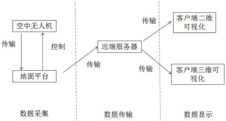
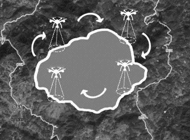
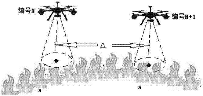
[0028] Such as Figure 1 to Figure 5 As shown, this embodiment provides a method and system for real-time extraction and visualization of fire boundary vector information, including three parts: extraction of forest fire boundary based on unmanned aerial vehicles, transmission of forest fire boundary information, and visualization of forest fire boundary information. See figure 1 . Among them, the recording operation of UAV trajectory based on the forest fire boundary mainly solves how the operator can accurately record the forest fire boundary. The transmission of forest fire boundary information mainly refers to the spatial information of the fire boundary trajectory obtained by the operator on the spot. After resampling, the smooth data and the obtained time information will be sent to the server as a message, and the server program will analyze the...


PUM


Abstract

The invention relates to a fire boundary vector information real-time extraction and visualization method and system. With the advantage that an unmanned aerial vehicle is not affected by harsh conditions in the wild being made full utilization of, the unmanned aerial vehicle is equipped with a GPS module, a trajectory control module and a data preprocessing module and the like, and operating personnel can control the unmanned aerial vehicle to fly right over the boundary of a fire scene and record the flight path at regular time under the guidance of ground platform real-time videos, wherein the recorded flight path of the unmanned aerial vehicle can represent the boundary of the fire scene; after re-sampling pretreatment of the trajectory, the forest fire boundary data can be transmitted to a remote server through a communication module; a server program analyzes a message and writes the whole boundary of the fire scene into a database; for large-range forest fire, the invention also considers a multi-UAV collaborative boundary obtaining method; and finally, decision-aid visualized software can read data from the database and updates the data regularly, and decision personnel can know fire scene situations in a two-dimensional or three-dimensional virtual forest environment in real time.

Description

technical field [0001] The invention relates to the field of forest fire control, in particular to a method and system for real-time extraction and visualization of fire boundary vector information. Background technique [0002] Forest fire is a highly destructive natural disaster. Once the fire spreads, it is difficult for people to take effective measures to control the fire in a timely manner due to insufficient fire extinguishing equipment and inconvenient transportation around the forest fire. spread further. After the forest fire spreads, the change of the fire boundary information can be obtained in real time, and the direction of the forest fire spread can be judged in a short period of time, which is of great significance for assisting decision-making in fire fighting and informationization of forest fires. [0003] The existing patents on forest fire monitoring mainly focus on the detection and discovery of fire ignition points, but there are no related patents on...

Claims


Application Information

Patent Timeline
Patent Type & Authority Applications(China)
IPC IPC(8): G06T7/13G06T7/62
CPCG06T2207/10016G06T2207/30188
Inventor 李建微胡奎陈思喜李晓雯罗永珍
Owner FUZHOU UNIV
Why Eureka
Try Eureka