Mobile terminal locating and correcting method and system

A mobile terminal and positioning correction technology, applied in the field of computer and geographic information science, can solve the problems of positioning satellite and receiver electromagnetic signal delay change, offset, etc.

Active Publication Date: 2017-08-01
HARBIN UNIV
View PDF7 Cites 12 Cited by
  • Summary
  • Abstract
  • Description
  • Claims
  • Application Information

AI Technical Summary

Problems solved by technology

[0007] In the existing method of position positioning through GPS, the electromagnetic wave signal between the positioning satellite and the receiver will be interfered by the weather environment, such as changes in the ionosphere in the atmosphere, or changes in the earth's magnetic field, etc. Causes the change or offset of the electromagnetic signal delay between the positioning satellite and the receiver. Therefore, when the positioning is performed by the mobile terminal, the positioning data under certain weather conditions will have a large deviation from the actual position.

Method used


Image

  • Mobile terminal locating and correcting method and system
  • Mobile terminal locating and correcting method and system

Examples


Embodiment Construction

[0057] In order to enable those skilled in the art to better understand the solutions of the present invention, the technical solutions in the embodiments of the present invention will be clearly and completely described below in conjunction with the drawings in the embodiments of the present invention. Obviously, the described embodiments are only It is a part of embodiments of the present invention, but not all embodiments. Based on the embodiments of the present invention, all other embodiments obtained by persons of ordinary skill in the art without making creative efforts belong to the protection scope of the present invention.

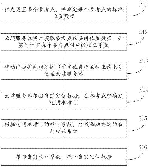
[0058] In order to improve the positioning accuracy of the mobile terminal, an embodiment of the present invention provides a mobile terminal positioning correction method, such as figure 1 shown, including:

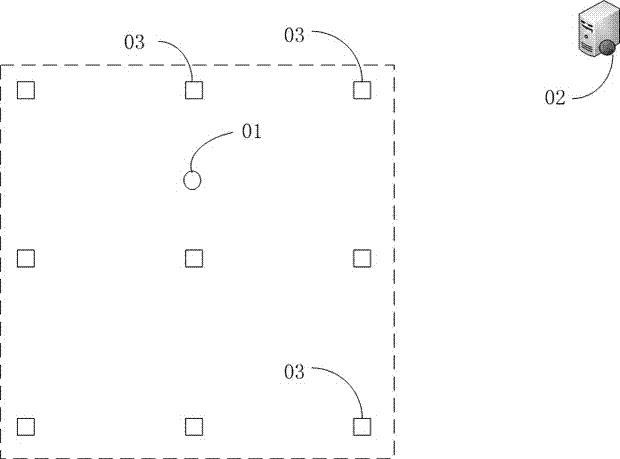
[0059] S11. Presetting a plurality of reference points, and determining the standard position data of each of the reference points;

[0...


PUM


Abstract

The invention discloses a mobile terminal locating and correcting method and system. The method comprises the following steps: presetting reference points, and measuring standard position data of the reference points; obtaining real-time position data of the reference points by a cloud server, and calculating a correction coefficient corresponding to each reference point in real time; sending a correction request of current locating data to the cloud server by a mobile terminal; determining the selected reference point in the reference points by the cloud server; generating a current correction coefficient of the mobile terminal according to the correction coefficient of the selected reference point; and correcting the current locating data according to the current correction coefficient. As the offset mode of the position where the mobile terminal is located is consistent with the offset mode of the locating data of the selected reference point, the current locating data of the mobile terminal of a user can be effectively corrected by the current correction coefficient of the selected reference point so as to obtain a locating result with high accuracy.

Description

technical field [0001] The invention relates to the fields of computer and geographic information science, in particular to a method and system for positioning and correcting a mobile terminal. Background technique [0002] Geographic information system can rely on computer technology to process, store, extract, manage and analyze geographic information. The 3S integrated technology system provides new analysis methods and technical guarantees for solving modern geoscience problems with a wider area and higher complexity; typical applications include, by storing map information in the computer, making electronic Map; then, combined with the global positioning system, people can quickly query the location of the target on the map through the terminal. [0003] As one of the most widely used positioning systems at present, the Global Positioning System (Global Positioning System, GPS) can perform real-time positioning and navigation around the world by using positioning satel...

Claims


Application Information

Patent Timeline
Patent Type & Authority Applications(China)
IPC IPC(8): H04W4/02H04W64/00
CPCH04W4/023H04W64/00
Inventor 王晓迪
Owner HARBIN UNIV
Why Eureka
Try Eureka