Method for quantitative analysis of impact on road travel time from urban built environment

A travel time and quantitative analysis technology, applied in road vehicle traffic control systems, traffic flow detection, design optimization/simulation, etc. , to improve the efficiency of road network traffic, reduce traffic congestion and road travel time, and improve awareness.

Active Publication Date: 2017-08-04
DALIAN UNIV OF TECH
View PDF4 Cites 11 Cited by
  • Summary
  • Abstract
  • Description
  • Claims
  • Application Information

AI Technical Summary

Problems solved by technology

[0003] However, these methods are often unable to analyze the main factors affecting road travel time, and are limited by the built environment attributes and data of the research area itself, so it is difficult for the research results to be directly applied to other areas.

Method used


Image

  • Method for quantitative analysis of impact on road travel time from urban built environment
  • Method for quantitative analysis of impact on road travel time from urban built environment
  • Method for quantitative analysis of impact on road travel time from urban built environment

Examples


Embodiment Construction

[0034] The specific embodiment of the present invention will be described in detail below in conjunction with examples, and the implementation effect of the invention will be simulated.

[0035] 1. Basic data

[0036] The road section between the intersection of Gongyeba Road and Houhai Avenue in Nanshan District, Shenzhen, and the intersection of Qiaocheng East Road and Baishi Road is selected as the case study object. Use the actual data of all taxis on the road segment between 7:30 and 9:30 on June 9, 2014 to June 13, 2014.

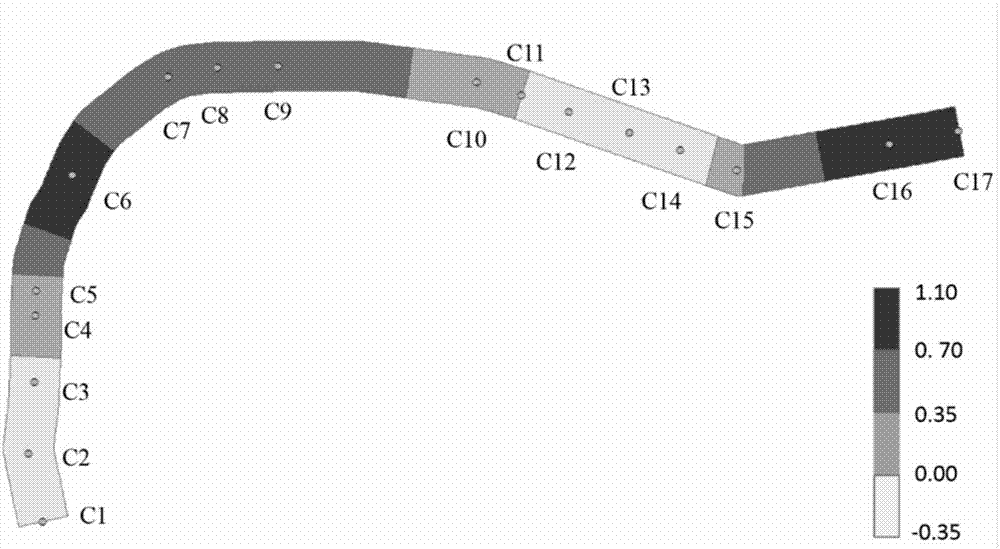
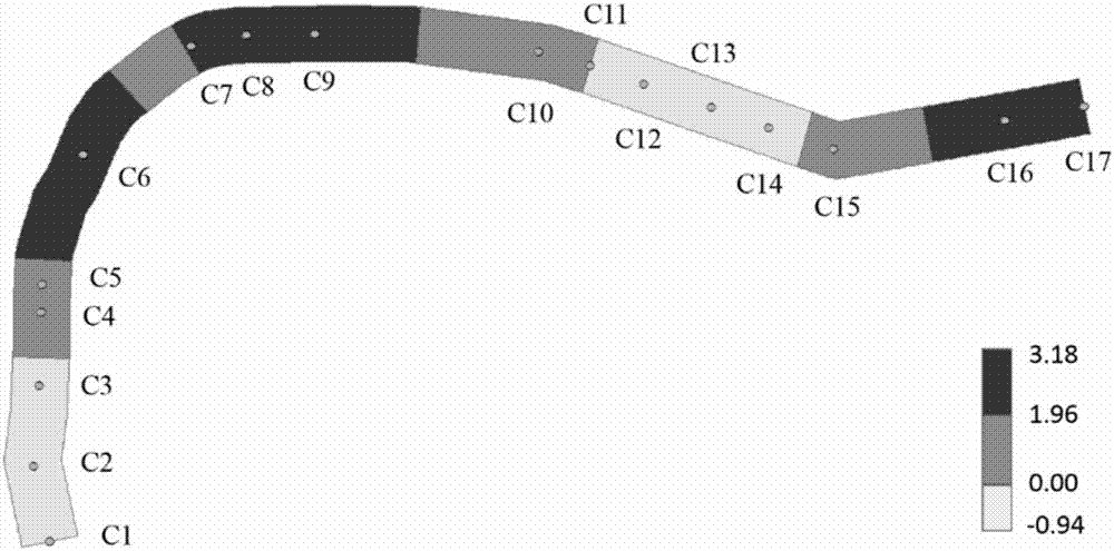
[0037] First divide the research road into 397 sections by 25 meters. Then, according to the road section and time period to be studied, the collected taxi GPS data is screened, corrected and matched, and the average speed and passenger load ratio of all taxis on each road section are calculated. Finally, according to the geographical information data of the road network, the number of buildings, banks, hotels, pharmacies, parking lots, supermarkets,...


PUM


Abstract

The invention belongs to the technical field of urban traffic planning and traffic big data research, and provides a method for the quantitative analysis of impact on road travel time from an urban built environment. The method comprises the steps: extracting the mean speed of all small road segments and the attribute information of the built environment according to the GPS data of taxies on a road and the geographic information data; secondly taking the mean speed of all small road segments as a dependent variable, taking the attribute of the built environment as a key independent variable, taking a nearest intersection type virtual variable as an adjustment variable, giving consideration to the mutual of the key independent variable and the dependent variable and carrying out the regression analysis, and selecting the key independent variable, which obviously affects the mean speed of the road segments, from the regression result; finally substituting the extracted key independent variable into a geographic weighted regression model, and carrying out the quantitative analysis. The beneficial effects of the invention are that the method is used for adjusting the attributes of the urban built environment for a traffic planning and management department, and improves the operation efficiency of a road network, and provides a decision-making basis.

Description

technical field [0001] The invention belongs to the field of urban traffic planning and traffic big data research, and particularly relates to the application of urban taxi GPS data and spatial geographic information data to study the influence of urban built environment on road travel time. Background technique [0002] In recent years, with the strengthening of people's concept of travel time and the deterioration of traffic road network operation efficiency, the research on road travel time has become a hot spot in the research of intelligent transportation systems. Most of the existing research on road travel time is based on traffic flow theory or data-driven methods for road travel time estimation and prediction. For example, in "Arterial travel time forecast with streaming data: A hybrid approach of flow modeling and machine learning" by Hofleitner A, a hybrid model framework was proposed using a large number of floating car GPS data to estimate the main line travel t...

Claims


Application Information

Patent Timeline
Patent Type & Authority Applications(China)
IPC IPC(8): G08G1/01G06F17/50
CPCG08G1/0137G06F30/20G08G1/0112G08G1/0129G08G1/052G06F17/18
Inventor 钟绍鹏王全志王仲邹延权程荣李旭丰
Owner DALIAN UNIV OF TECH
Why Eureka
Try Eureka