Layout system for road test and detection
A technology for measuring and designing roads, which is applied in the directions of measuring instruments, measuring devices, surveying and mapping, and navigation. It can solve the problems of inaccurate distance values, difficult construction and labor, and achieve the effect of reducing large errors.
- Summary
- Abstract
- Description
- Claims
- Application Information
AI Technical Summary
Problems solved by technology
Method used
Image
Examples
Embodiment 1
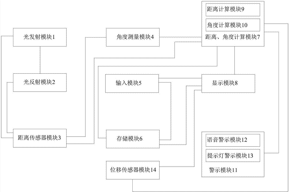
[0027] A measurement system for road test detection, including: light emitting module 1: used to send out a light beam for measurement; light reflection module 2: used to reflect the light beam emitted by the light emitting module; distance sensor module 3: used to measure the light beam The distance between the reflection module 2 and the light emission module 1; the angle measurement module 4: for measuring the angle between the light beam emitted by the light emission module 1 and the light reflection module 2 and the horizontal axis; the input module 5: for Input the measured target distance, initial position, target position, and the angle between the line between the initial position and the target position and the horizontal axis; storage module 6: for storing the target distance, initial position, target position and initial position input by the input module and the angle information between the line of the target position and the horizontal axis; distance, angle calcu...
Embodiment 2
[0029] A measurement system for road test detection, including: light emitting module 1: used to send out a light beam for measurement; light reflection module 2: used to reflect the light beam emitted by the light emitting module; distance sensor module 3: used to measure the light beam The distance between the reflection module 2 and the light emission module 1; the angle measurement module 4: for measuring the angle between the light beam emitted by the light emission module 1 and the light reflection module 2 and the horizontal axis; the input module 5: for Input the measured target distance, initial position, target position, and the angle between the line between the initial position and the target position and the horizontal axis; storage module 6: for storing the target distance, initial position, target position and initial position input by the input module and the angle information between the line of the target position and the horizontal axis; distance, angle calcu...
Embodiment 3
[0031] A measurement system for road test detection, including: light emitting module 1: used to send out a light beam for measurement; light reflection module 2: used to reflect the light beam emitted by the light emitting module; distance sensor module 3: used to measure the light beam The distance between the reflection module 2 and the light emission module 1; the angle measurement module 4: for measuring the angle between the light beam emitted by the light emission module 1 and the light reflection module 2 and the horizontal axis; the input module 5: for Input the measured target distance, initial position, target position, and the angle between the line between the initial position and the target position and the horizontal axis; storage module 6: for storing the target distance, initial position, target position and initial position input by the input module and the angle information between the line of the target position and the horizontal axis; distance, angle calcu...
PUM
 Abstract
Description
Claims
Application Information
 - R&D
- Intellectual Property
- Life Sciences
- Materials
- Tech Scout
- Unparalleled Data Quality
- Higher Quality Content
- 60% Fewer Hallucinations
Browse by: Latest US Patents, China's latest patents, Technical Efficacy Thesaurus, Application Domain, Technology Topic, Popular Technical Reports.
© 2025 PatSnap. All rights reserved.Legal|Privacy policy|Modern Slavery Act Transparency Statement|Sitemap|About US| Contact US: help@patsnap.com

