Data organization and management method and system for three-dimensional digital park

A technology of three-dimensional digital and data organization, which is applied in the direction of electrical digital data processing, special data processing applications, instruments, etc., and can solve the problems of lack of details in geographical location and the inability to solve non-GIS model access problems, etc.

Active Publication Date: 2017-09-12
盈嘉互联(北京)科技有限公司 +6
View PDF2 Cites 27 Cited by
  • Summary
  • Abstract
  • Description
  • Claims
  • Application Information

AI Technical Summary

Problems solved by technology

The current digital park uses a pure GIS system. The 3D models in the system (such as buildings, pipes, trees) are all rough models, which have geographical locations but lack details, and cannot solve the interface of non-GIS models (such as BIM models). entry problem

Method used


Image

  • Data organization and management method and system for three-dimensional digital park
  • Data organization and management method and system for three-dimensional digital park
  • Data organization and management method and system for three-dimensional digital park

Examples


Embodiment 1

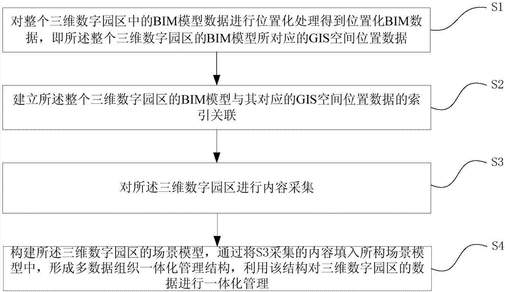
[0045] figure 1 It shows a multi-data organization and management method for constructing a three-dimensional digital park with BIM+GIS data as the core data. The positional BIM data is obtained by performing positional processing on the BIM model data without spatial position, and associated with GIS spatial data. Realize the integrated management of heterogeneous and multi-granularity data in the 3D digital park, including the following steps:

[0046] S1. Positioning the BIM model data in the entire three-dimensional digital park to obtain positional BIM data, that is, the GIS spatial position data corresponding to the BIM model of the entire three-dimensional digital park;

[0047] S2. Establishing an index association between the BIM model of the entire three-dimensional digital park and its corresponding GIS spatial location data;

[0048] S3. Collecting content of the three-dimensional digital park;

[0049] S4. Construct the scene model of the 3D digital park, and form...

Embodiment 2

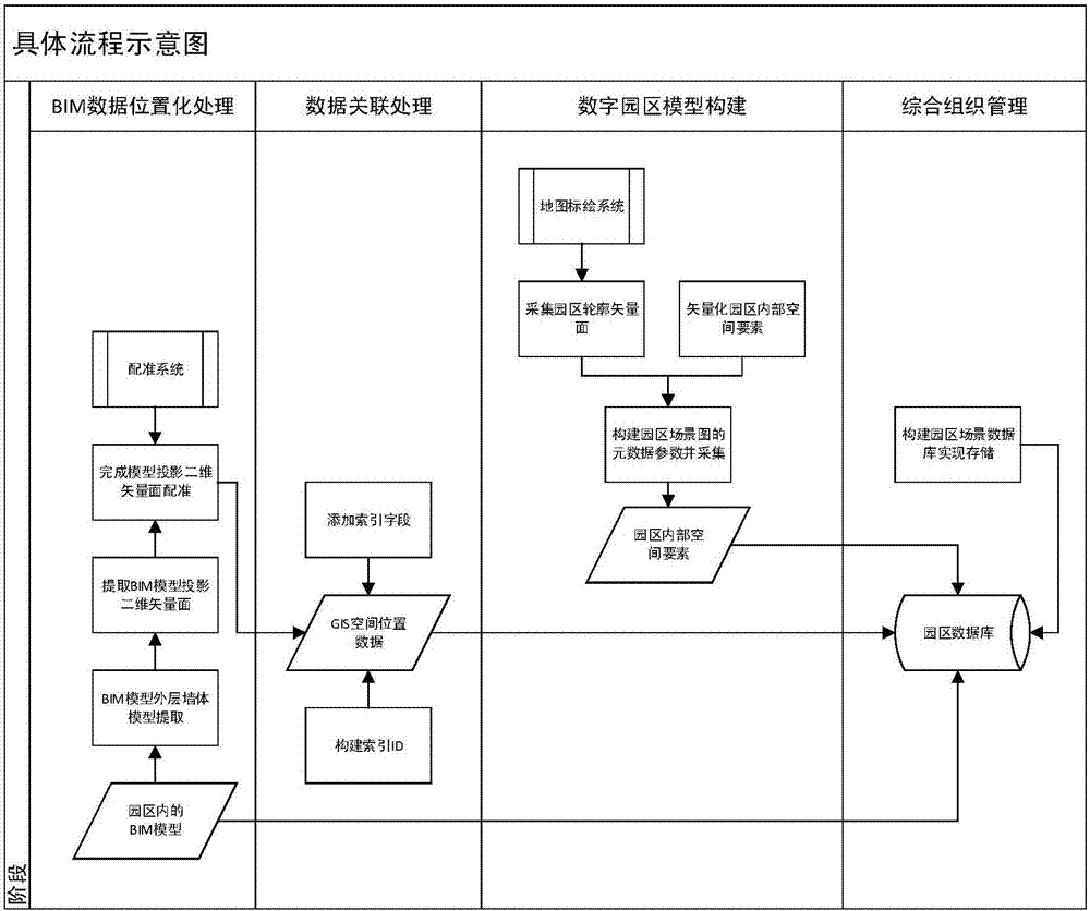
[0080] see Figure 4 , this embodiment provides an organization and management system for constructing a three-dimensional digital park with BIM+GIS data as the core data, including:

[0081] BIM data location module 1 is used to locate the BIM model of the building in the three-dimensional digital park, extract the outer contour map of the BIM model, and acquire the model by registering the outer contour map of the BIM model with the online map matching spatial location data;

[0082] Data association module 2, for establishing the index correlation of the BIM model of described three-dimensional digital park and its corresponding GIS spatial location data;

[0083] The content collection module 3 is used to build a map drawing system of the park, collect the park boundary of the digital park by means of polygon plotting, construct and collect the metadata parameters of the scene map, and obtain the content of the elements in the park;

[0084] The data integration manageme...


PUM


Abstract

The invention provides a data organization and management method and system for a three-dimensional digital park. The method includes the steps that 1, positional processing is conducted on BIM data in the whole three-dimensional digital park to obtain positional BIM data, namely, GIS spatial position data corresponding to a BIM of the whole three-dimensional digital park; 2, the index relation between the BIM of the whole three-dimensional digital park and the GIS spatial position data corresponding to the BIM is established; 3, content collection is conducted on the three-dimensional digital park; 4, a scene model of the three-dimensional digital park is built, a multi-data organization integrated management structure is formed by filling the built scene model with content collected in the step 3, and integrated management is conducted on the data of the three-dimensional digital park with the structure. According to the scheme, the three-dimensional digital park is built with the scene model of the three-dimensional digital park, seamless integration of spatial data and non-spatial data is achieved, and the purpose of integrated management of the three-dimensional digital park from macroscopic visualization to microscopic visualization is achieved by adopting the BIM data and GIS data combined mode.

Description

technical field [0001] The present invention relates to the field of digital park management, and more specifically, provides a data organization and management method and system for a three-dimensional digital park. Background technique [0002] Building Information Modeling (Building Information Modeling, BIM) is a technical means to realize full-detail modeling of buildings, and the model obtained by this means is called BIM model. Each BIM model is a detailed description of a building, and its precision is very high, but the BIM model is established from the design stage of the building, and it is a 3D design model that simulates the real. Therefore, there is no actual geographical location, and it cannot be combined with a digital park with a real geographical location. [0003] Geographic Information System (GIS, Geographic Information System) is a comprehensive application system applicable to wide areas. The system collects real data based on the real geographical ...

Claims


Application Information

Patent Timeline
Patent Type & Authority Applications(China)
IPC IPC(8): G06F17/50
CPCG06F30/13
Inventor 李程鹏张纯
Owner 盈嘉互联(北京)科技有限公司
Why Eureka
Try Eureka