Multi-source remote sensing image surface object classification method based on double-channel convolution step network

A technology for classification of remote sensing images and features, applied in the field of classification of multi-source remote sensing images and features, can solve the problems of consuming manpower and financial resources and high costs, and achieve improved classification accuracy, high classification accuracy and representative effects

Active Publication Date: 2017-10-20
XIDIAN UNIV
View PDF7 Cites 15 Cited by
  • Summary
  • Abstract
  • Description
  • Claims
  • Application Information

AI Technical Summary

Problems solved by technology

[0003] When using artificial neural networks to achieve fusion and classification, supervised classification methods are oft

Method used


Image

  • Multi-source remote sensing image surface object classification method based on double-channel convolution step network
  • Multi-source remote sensing image surface object classification method based on double-channel convolution step network
  • Multi-source remote sensing image surface object classification method based on double-channel convolution step network

Examples


Embodiment Construction

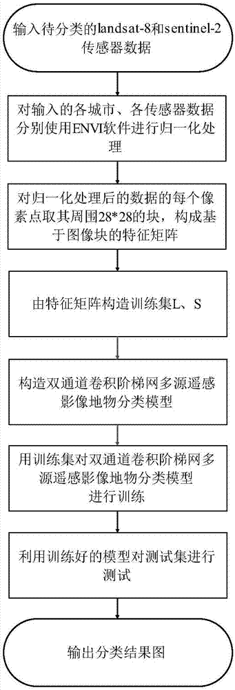
[0042] The present invention will be further described below in conjunction with the accompanying drawings.

[0043] see figure 1 , the concrete implementation steps of the present invention are as follows:

[0044] Step 1. The multispectral data of the five cities of Berlin, Paris, Hong Kong, Rome, and Sao Paulo obtained by the landsat-8 sensor were normalized using ENVI software, and the normalized multispectral data were obtained, which were recorded as landsat_berlin , landsat_paris, landsat_hong_kong, landsat_rome, landsat_sao_paulo;

[0045] The multispectral data of the five cities of Berlin, Paris, Hong Kong, Rome, and Sao Paulo obtained by the landsat-8 sensor are all 9 bands, and the image sizes are 666×643, 988×1160, 529×528, 447×377, 871× 1067;

[0046] When using ENVI software to normalize the data, the selected normalization method is equalize;

[0047] Step 2: Normalize the multispectral data of the five cities of Berlin, Paris, Hong Kong, Rome, and Sao Paul...


PUM


Abstract

The invention discloses a multi-source remote sensing image surface object classification method based on a double-channel convolution step network. The multispectral data of regions to be classified obtained by a landsat-8 sensor and a sentinel-2 sensor are normalized by suing ENVI software so as to obtain the normalized multispectral data; 28x28 blocks around each element of the normalized multispectral data are taken to represent the original element value so as to form a feature matrix based on the image blocks; multiple blocks are randomly selected from each class to for training data sets L and S; a multi-source remote sensing image surface object classification model based on the double-channel convolution step network is constructed; the multi-source remote sensing image surface object classification model based on the double-channel convolution step network is trained by using the training data sets L and S; and test data sets are classified by using the trained multi-source remote sensing image surface object classification model based on the double-channel convolution step network. The high multi-source image classification accuracy can be acquired by only using less class tag samples so that the method can be used for target detection.

Description

technical field [0001] The invention belongs to the field of image processing, and in particular relates to a multi-source remote sensing image classification method based on a double-channel convolution ladder network. Background technique [0002] With the development of remote sensing technology, more and more multi-spectral, multi-resolution, and multi-temporal image data of the same area are acquired by various remote sensors, which provide rich and valuable information for natural resource investigation and environmental monitoring. material. However, the image data obtained by various single remote sensing methods have obvious limitations and differences in geometry, spectrum, and spatial resolution, which lead to their limited ability to be used for classification. Obviously, it is very important to combine their respective strengths and complementarities for classification. Information fusion technology is a technology for comprehensive processing of multiple info...

Claims


Application Information

Patent Timeline
IPC IPC(8): G06K9/62
CPCG06F18/2155G06F18/243G06F18/25
Inventor 焦李成屈嵘高倩马文萍杨淑媛侯彪刘芳尚荣华张向荣张丹唐旭马晶晶
Owner XIDIAN UNIV
Why Eureka
Try Eureka