UAV geographical big data information processing method based on cloud platform

An information processing method and geographic data technology, applied in the field of UAV data processing, can solve problems such as relational data performance bottlenecks, server crashes, large data volume performance problems, etc., to ensure real-time access and persistence, and solve distance restrictions , the effect of solving performance bottlenecks

Active Publication Date: 2021-01-05
一飞智控(天津)科技有限公司
View PDF6 Cites 0 Cited by
  • Summary
  • Abstract
  • Description
  • Claims
  • Application Information

AI Technical Summary

Problems solved by technology

[0003] However, the current transmission of UAV geographical data based on the Satcom network of the ground station is affected by the network delay of the Satcom network, and the transmission delay of the UAV geographic data is serious. Due to the bandwidth limitation of the Satcom network, the number of UAVs is also problematic. It cannot be ignored; UAV geographic data transmission based on digital radio stations can only receive UAV geographic data within a range of tens of kilometers, which is relatively limited by distance
[0004] Existing relational databases, when there is a large amount of data, high-frequency access operations will reach the performance bottleneck of relational data; the existing server passively receives browser requests before returning data. When the server resources are not enough to support, the server faces the risk of crashing; the existing UAV geographic data display method displays all the data, and there will be performance problems when there is a large amount of data

Method used


Image

  • UAV geographical big data information processing method based on cloud platform

Examples


Embodiment Construction

[0022] The present invention will be described in further detail below in conjunction with the accompanying drawings and specific embodiments. It should be understood that the specific embodiments described here are only used to explain the present invention, not to limit the present invention.

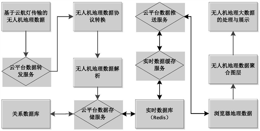
[0023] The cloud platform effectively and reasonably integrates resources, improves resource utilization to achieve higher efficiency, and can provide standardized services and applications; compared with traditional data centers, the cloud platform is highly flexible and scalable. These characteristics can flexibly store, manage, process and display UAV geographic big data on demand.

[0024] In order to realize the processing and display of UAV geographic big data, the present invention proposes a processing method system based on a cloud platform to realize UAV geographic big data.

[0025] As shown in the figure, the method for processing big data information of unmanned aerial v...


PUM


Abstract

The invention discloses an unmanned aerial vehicle geographic big data information processing method in virtue of a cloud platform. The method comprises the following steps that: 1) through cloud platform data forwarding service, obtaining the real-time state data of an unmanned aerial vehicle from a Yunhang lamp; 2) carrying out analysis to obtain the geographic data information of the unmanned aerial vehicle; and 3) through cloud platform data storage service, independently storing the geographic data information of the unmanned aerial vehicle and the real-time state data of the unmanned aerial vehicle into a real-time database and a relational database. By use of the method, the cloud platform data forwarding service is used for transmitting the geographic data of the unmanned aerial vehicle from the Yunhang lamp, network delay is greatly lowered, a distance restriction problem is solved, and the geographic data of the unmanned aerial vehicle can be displayed at any time and place; and in addition, a real-time database caching and indexing technology is used to solve the problem of the performance bottleneck of the relational database due to the high concurrency of the geographic data of the unmanned aerial vehicle. The geographic data of the unmanned aerial vehicle is separately stored, and the real-time storage and the persistence of the geographic data of the unmanned aerial vehicle are guaranteed to meet different data displaying requirements.

Description

technical field [0001] The invention relates to the technical field of UAV data processing, in particular to a method for processing UAV geographic big data information by means of a cloud platform. Background technique [0002] The application of drones is becoming more and more extensive. Correspondingly, a large amount of geographic data information generated by drones, how to effectively process the geographic data of drones to obtain the huge value contained in it, and display it intuitively, is very necessary. UAVs are flexible in operation and can perform tasks in a variety of abnormal environments. During the actual operation of the UAV, it is necessary to display the position data and various parameter data of the UAV operation in real time, so as to control the current state of the UAV in real time, and to adjust the movement direction and attitude of the UAV in real time. [0003] However, the current transmission of UAV geographical data based on the Satcom net...

Claims


Application Information

Patent Timeline
Patent Type & Authority Patents(China)
IPC IPC(8): G06F16/29G06F16/28G06F16/22G06F16/2453
CPCG06F16/2264G06F16/24539G06F16/284G06F16/29
Inventor 曹品廉许毅
Owner 一飞智控(天津)科技有限公司
Why Eureka
Try Eureka