A self-learning waypoint trajectory flight method and system for unmanned aerial vehicles

A UAV, waypoint technology, applied in control/adjustment systems, navigation calculation tools, three-dimensional position/channel control and other directions, can solve the problems of high cost of UAV route management, poor repeatability, etc. Realize the effect of automatic route planning and management

Active Publication Date: 2020-05-15
HARBIN INST OF TECH AT WEIHAI
View PDF10 Cites 0 Cited by
  • Summary
  • Abstract
  • Description
  • Claims
  • Application Information

AI Technical Summary

Problems solved by technology

[0005] The invention provides a UAV self-learning waypoint trajectory flight method and its system to solve the technical problems of high cost and poor repeatability of the existing UAV route management

Method used


Image

  • A self-learning waypoint trajectory flight method and system for unmanned aerial vehicles
  • A self-learning waypoint trajectory flight method and system for unmanned aerial vehicles
  • A self-learning waypoint trajectory flight method and system for unmanned aerial vehicles

Examples


Embodiment Construction

[0043] The specific implementation manners of the present invention will be further described in detail below in conjunction with the accompanying drawings and embodiments. The following examples are used to illustrate the present invention, but are not intended to limit the scope of the present invention.

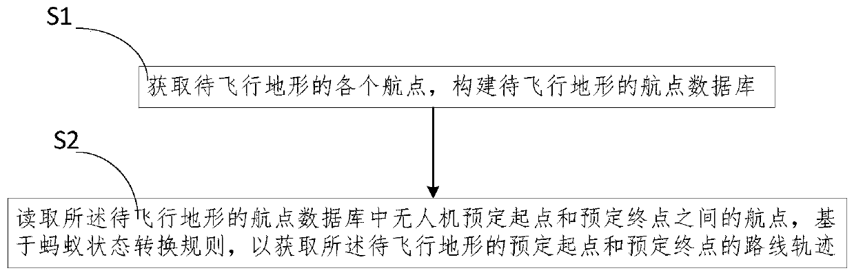
[0044] see figure 1 As shown, the present invention provides a kind of unmanned aerial vehicle self-learning waypoint trajectory flight method, comprises the following steps:

[0045] Step S1. Obtain each waypoint of the terrain to be flown, and construct a waypoint database of the terrain to be flown;

[0046] Step S2. Read the waypoints between the predetermined starting point and the predetermined end point of the drone in the waypoint database of the terrain to be flown, and obtain the route of the predetermined starting point and the predetermined end point of the terrain to be flown based on the ant state transition rules track.

[0047] It should be noted that, i...


PUM


Abstract

The invention provides a UAV self-learning waypoint track flight method and system thereof, wherein the method comprises the following steps: acquiring each waypoint of the terrain to be flown, constructing a waypoint database of the terrain to be flown; The waypoints between the scheduled starting point and the scheduled end point of the UAV in the terrain's waypoint database are based on the ant state transition rules to obtain the route trajectory of the scheduled starting point and the scheduled end point of the terrain to be flown. A kind of UAV self-learning waypoint trajectory flight method of the present invention, by constructing the waypoint database of the terrain to be flown, when the predetermined starting point and the predetermined end point are input, the trajectory route can be quickly passed through the ant colony algorithm, thereby making the UAV After the first manual flight, in the automatic flight mode, the drone can automatically select the appropriate flight trajectory according to the real-time situation in a complex environment, quickly pass the target area to reach the predetermined end point, and can also automatically select according to the complex situation after the task is completed. land or return.

Description

technical field [0001] The present invention relates to the technical field of unmanned route planning, and more specifically, to a method and system for self-learning waypoint trajectory flight of unmanned aerial vehicles. Background technique [0002] Existing UAV operations are generally managed by the ground station system. The ground station system acts as the manager. After planning the route, the planned route is sent to the flight control system on the UAV through the radio station. The planned route controls the UAV to execute the flight mission. During the execution process, the track point information is sent to the ground station system in real time. The ground station system receives the track point information sent by the flight control system in real time, and generates a job file after the flight mission. [0003] The existing management mode of UAV operation has the following disadvantages: 1. When the route planning is carried out at the operation site thro...

Claims


Application Information

Patent Timeline
Patent Type & Authority Patents(China)
IPC IPC(8): G01C21/20G05D1/10
CPCG01C21/20G05D1/101
Inventor 孙明健张筱磊刘强姚统杜海吕胜苗张文瀚
Owner HARBIN INST OF TECH AT WEIHAI
Why Eureka
Try Eureka