
Low-altitude monitoring system based on Beidou satellite communication

A satellite communication and monitoring system technology, applied in the field of low-altitude monitoring systems, can solve the problems of signal transceiver equipment, such as large volume, easy to be blocked, weak tracking signal, etc., to achieve the effect of solving weak tracking signal, easy to be blocked, and small size

Pending Publication Date: 2017-11-17
四川联丰云网科技有限公司
View PDF34 Cites 9 Cited by
  • Summary
  • Abstract
  • Description
  • Claims
  • Application Information

AI Technical Summary

Problems solved by technology

[0007] The invention provides a low-altitude monitoring system based on Beidou satellite communication to solve the defects of the existing aircraft tracking means that the tracking signal is weak and easily blocked, and the signal transceiver equipment is large in size

Method used


Image

  • Low-altitude monitoring system based on Beidou satellite communication

Examples


Embodiment Construction

[0026] In order to make the object, technical solution and advantages of the present invention clearer, the present invention will be further described in detail below in conjunction with the embodiments and accompanying drawings.

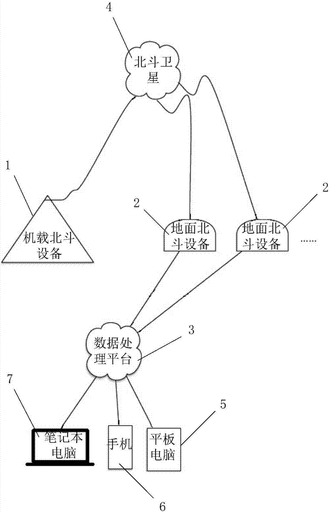
[0027] Such as figure 1 As shown, the low-altitude surveillance system based on Beidou satellite communication provided by the present invention includes an airborne Beidou device 1 , a ground Beidou device 2 and a data processing platform 3 .

[0028] The airborne Beidou device 1 is installed on the aircraft to detect the flight parameters of the aircraft in real time, and send the flight parameters to the ground Beidou device 2 through the Beidou satellite 4 . The flight parameters include the time, and the longitude, latitude, flight altitude, flight speed and flight direction of the aircraft at the time.

[0029] The ground Beidou device 2 is used to send the received flight parameters to the data processing platform 3 in real time. The data ...


PUM


Abstract

The invention discloses a low-altitude monitoring system based on Beidou satellite communication. On the basis of the short message communication function of the Beidou satellite, airborne Beidou equipment is installed at a plane and ground Beidou equipment is installed on the ground, and the ground Beidou equipment is connected with a data processing platform; the airborne Beidou equipment detects a flight parameter of the plane and the flight parameter is sent to the ground Beidou equipment by the Beidou satellite; and the ground Beidou equipment sends the flight parameter to the data processing platform and the data processing platform calculates the location of the plane based on the flight parameter, thereby realizing tracking and monitoring of the plane. According to the invention, with the signal transceiving equipment based on Beidou satellite communication, defects that the tracking signal is weak and is easy to block according to the existing plane tracking technique are overcome. Meanwhile, because the decoding chip as the core of the Beidou chip has the small size, the whole signal transceiving equipment is miniaturized and thus the equipment is convenient to carry.

Description

technical field [0001] The invention relates to Beidou positioning technology, in particular to a low-altitude monitoring system based on Beidou satellite communication. Background technique [0002] Aircraft tracking technology generally includes mobile network-based tracking technology, radio-based tracking technology, satellite communication-based technology and radar-based technology, all of which have drawbacks: [0003] The tracking technology based on the mobile network is limited by the coverage height of the mobile network. Generally, there is no mobile network signal unless special base station enhancement equipment is installed above 1000 meters. Aircraft generally fly at an altitude of over 1,000 meters, and ships are far away from the mainland. This technology is not universal and can only be used when the ground signal is strong. [0004] Radio-based tracking technology requires the deployment of a large number of receiving base stations, and the radio is easi...

Claims


Application Information

Patent Timeline
Patent Type & Authority Applications(China)
IPC IPC(8): G01S19/03G01S19/13H04B7/185H04W4/14
CPCH04B7/18506H04B7/18508H04W4/14G01S19/03G01S19/13
Inventor 李恒洪文军敬攀
Owner 四川联丰云网科技有限公司
Learn More