
Desert plant remote sensing identification method using object-oriented multi-source information fusion

A multi-source information fusion, desert plant technology, applied in scene recognition, character and pattern recognition, instruments, etc., to achieve the effect of improving the effect

Active Publication Date: 2017-11-24
XINJIANG INST OF ECOLOGY & GEOGRAPHY CHINESE ACAD OF SCI
View PDF3 Cites 11 Cited by
  • Summary
  • Abstract
  • Description
  • Claims
  • Application Information

AI Technical Summary

Problems solved by technology

[0005] The technical problem to be solved by the present invention is: in order to solve the problem of how to quickly and accurately identify desert plants, the present invention provides a remote sensing identification method for desert plants using object-oriented multi-source information fusion, mainly involving object-oriented remote sensing identification methods , Remote sensing interpretation technology based on multi-source information fusion

Method used


Image

  • Desert plant remote sensing identification method using object-oriented multi-source information fusion
  • Desert plant remote sensing identification method using object-oriented multi-source information fusion
  • Desert plant remote sensing identification method using object-oriented multi-source information fusion

Examples


Embodiment Construction

[0056] The present invention is described in further detail now in conjunction with accompanying drawing.

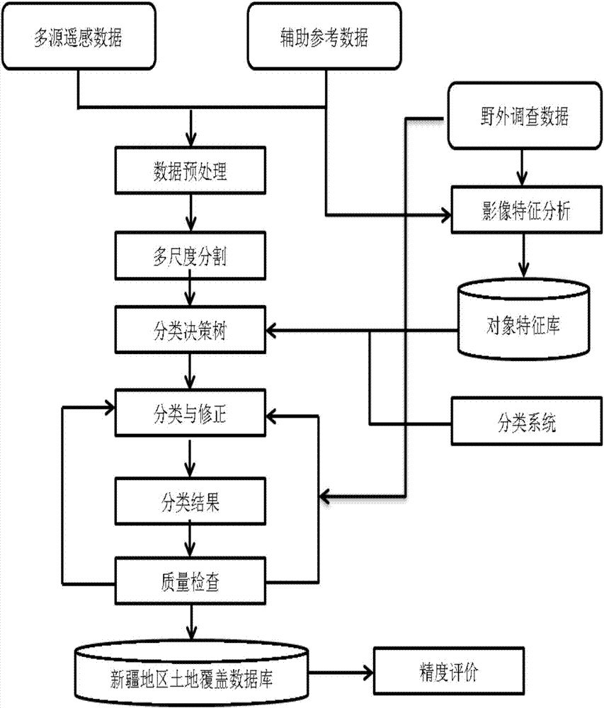
[0057] The flow chart of the present invention using multi-source remote sensing data to identify desert plant information is as follows: figure 1 shown. A remote sensing identification method for desert plants using object-oriented multi-source information fusion,

[0058] The following five units are adopted: large-area multi-source information mosaic unit, object-oriented image segmentation unit, multi-source information fusion unit, interpretation rule formulation unit and desert plant identification unit; the object-oriented multi-source information fusion system composed of the above units The remote sensing identification method of desert plants can quickly and accurately identify the distribution information and data of desert vegetation in a large area, provide technical support for relevant research institutions, public welfare organizations, enterprises and e...


PUM


Abstract

The invention relates to a desert plant remote sensing identification method using object-oriented multi-source information fusion. The method comprises the following five units: a large-area multi-source information inlay unit, an object-oriented image segmentation unit, a multi-source information fusion unit, an interpretation rule making unit and a desert plant identification unit. In the prior art, the following conditions that desert plant distribution is sparse; growth spectrum information is weak; desert plants are easily influenced by diffuse reflection; and phenomena of a mixed pixel and a same object with different spectrums are remarkable are not considered. Aiming at the above problems, the desert plant remote sensing identification method using the object-oriented multi-source information fusion is researched and developed so that problems that desert plant types and space-time distribution can not be accurately identified in fields of ecological remediation, a climatic change, a biological diversity, genetic development, poverty elimination and the like can be solved. A technical support is provided for a correlation research mechanism, a commonweal organization, an enterprise and a government. A data analysis basis is provided for exploitation, construction and management of a desert plant industry in an arid region.

Description

technical field [0001] The invention relates to computer digital image processing and pattern recognition, and the application field of remote sensing, in particular to a desert plant remote sensing recognition method utilizing object-oriented multi-source information fusion. Background technique [0002] Desert plants refer to sparse vegetation dominated by xeric semi-arbors, semi-shrubs, small semi-shrubs and shrubs, and are important vegetation landscapes in subtropical and temperate arid regions. It is mainly distributed in the vast Gobi desert starting from North Africa, going east through West Asia, Central Asia, and South Asia to northwest my country and Mongolia. In addition, it also has a certain area of ​​​​distribution in the deserts of North and South America and Australia. Desert vegetation is an indicator of local ecological environment evolution and climate change, and is also an important part of global land surface processes. It is related to the energy conv...

Claims


Application Information

Patent Timeline
Patent Type & Authority Applications(China)
IPC IPC(8): G06K9/00G06K9/62
CPCG06V20/13G06F18/24323G06F18/25
Inventor 常存
Owner XINJIANG INST OF ECOLOGY & GEOGRAPHY CHINESE ACAD OF SCI
Learn More