Map updating method and vehicle terminal

A vehicle-mounted terminal and map update technology, applied in the field of navigation, can solve the problems of map data deviation, cumbersome data acquisition, and long period of use, so as to reduce the update cycle, improve intelligence and accuracy, and reduce manual selection. link effect

Inactive Publication Date: 2017-12-26
HUAWEI DEVICE CO LTD
View PDF7 Cites 23 Cited by
  • Summary
  • Abstract
  • Description
  • Claims
  • Application Information

AI Technical Summary

Problems solved by technology

At present, the production and update of navigation system map data mainly include the following three methods: the first is to collect information manually, and then process the information to generate new navigation map data. The data obtained in this way is from collection to production And put into use for a long period, such as Google Street View car; the second is to obtain navigation map data through aerial photography and satellite imagery, this method is more cumbersome to obtain data, and is generally used to correct the deviation of map data; the third After collecting new road

Method used


Image

  • Map updating method and vehicle terminal
  • Map updating method and vehicle terminal
  • Map updating method and vehicle terminal

Examples


Embodiment Construction

[0068] The technical solutions in the embodiments of the present invention will be clearly and completely described below in conjunction with the accompanying drawings in the embodiments of the present invention. Obviously, the described embodiments are only part of the embodiments of the present invention, not all of them. Based on the embodiments of the present invention, all other embodiments obtained by persons of ordinary skill in the art without making creative efforts shall fall within the protection scope of the present invention.

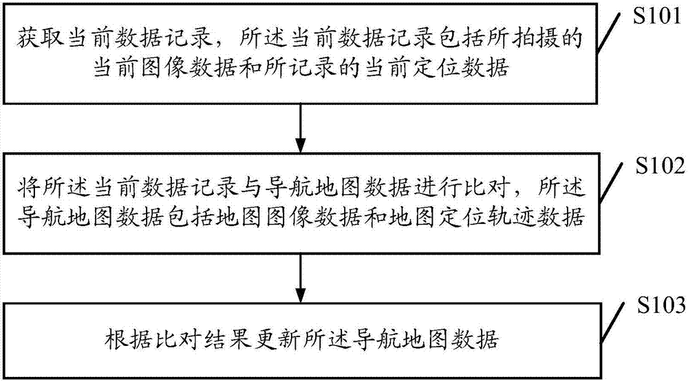
[0069] See figure 1 , figure 1 It is a schematic flowchart of a method for updating a map provided by an embodiment of the present invention. like figure 1 As shown, a method for updating a map provided by an embodiment of the present invention may include steps S101-S103.

[0070] S101. Acquire current data records, where the current data records include captured current image data and recorded current positioning data.

[0071] Specif...


PUM


Abstract

The embodiment of the invention discloses a map updating method and a vehicle terminal. The amp updating method includes the following steps: acquiring a current data record, wherein the current data record includes shot current image data and recorded current positioning data; comparing the current data record with navigation map data, wherein the navigation map data includes map image data and map positioning locus data; and updating the navigation map data according to the obtained comparison result. The method adopting the technical scheme in the embodiment of the invention is beneficial to improving the intelligence and accuracy of map updating and shortening the updating cycle.

Description

technical field [0001] The invention relates to the technical field of navigation, in particular to a map update method and a vehicle-mounted terminal. Background technique [0002] With the popularity of vehicles and the intelligent development of vehicle-mounted terminals, more and more people carry vehicle-mounted terminals such as vehicle-mounted navigation systems for real-time map navigation when traveling to avoid getting lost. At present, the production and update of navigation system map data mainly include the following three methods: the first is to collect information manually, and then process the information to generate new navigation map data. The data obtained in this way is from collection to production And put into use for a long period, such as Google Street View car; the second is to obtain navigation map data through aerial photography and satellite imagery, this method is more cumbersome to obtain data, and is generally used to correct the deviation of ...

Claims


Application Information

Patent Timeline
IPC IPC(8): G01C21/32G06F17/30
CPCG06F16/29G01C21/3859G01C21/3896G06F16/00G06F16/58G06F16/583G06F16/2379G01C21/30
Inventor 李德良
Owner HUAWEI DEVICE CO LTD
Why Eureka
Try Eureka