A method and system for marking directions in a computer three-dimensional geographic information scene

A geographic information and computer technology, applied in the field of data processing, can solve problems such as poor sense of direction and identification of the current position, and achieve the effect of accurate information, intuitive and easier identification

Active Publication Date: 2020-09-08
深圳航天智慧城市系统技术研究院有限公司
View PDF9 Cites 0 Cited by
  • Summary
  • Abstract
  • Description
  • Claims
  • Application Information

AI Technical Summary

Problems solved by technology

Taking the initial position of traditional markers pointing to the true north as an example, when the user adjusts the 3D scene camera to change the viewing angle, the markers such as the compass or the compass will be offset by the corresponding angle to mark the true north position, but there are many directions in the current operating population It is difficult for users who do not have a strong sense or have not received professional geographic information education to quickly identify the current position in this way

Method used


Image

  • A method and system for marking directions in a computer three-dimensional geographic information scene
  • A method and system for marking directions in a computer three-dimensional geographic information scene

Examples


Embodiment Construction

[0025] The invention discloses a method for marking directions in a computer three-dimensional geographic information scene, which comprises the following steps:

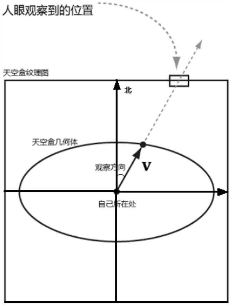
[0026] Step 1. When entering the 3D scene, the skybox has no orientation, but the sphere has orientation coordinates. First, determine the skybox picture corresponding to the forward direction according to the orientation coordinates of the sphere;

[0027] Step 2, mark the generated orientation information on the corresponding skybox picture;

[0028] Step 3: The sky picture marked with orientation information is projected into the sky of the current scene through the sky box, and the user can know the current orientation by observing the sky.

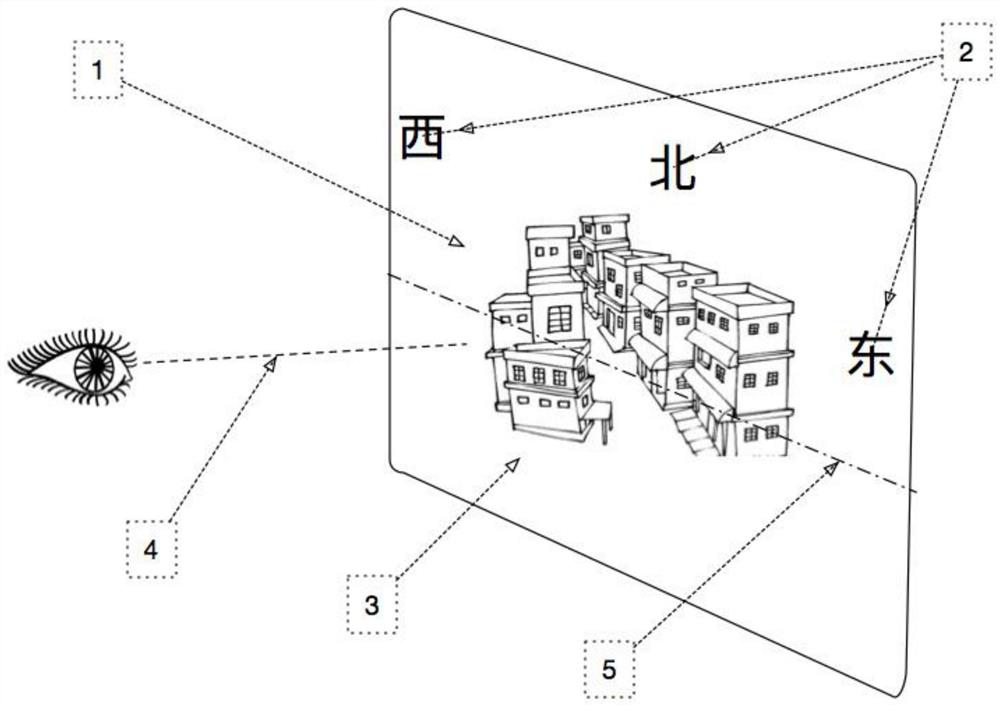
[0029] The orientation information includes characters, numbers, symbols or scales representing the orientation.

[0030] In the step 2, the orientation information is fused with the skybox picture in a translucent or similar manner to the skybox background, so as not to a...


PUM


Abstract

The invention provides a method and a system for labeling a direction in a three-dimensional geographic information scene of a computer. The method comprises the steps of step 1, firstly determining askybox picture corresponding to a forward direction according to an azimuthal coordinate of a sphere; step 2, labeling the generated azimuth information into the corresponding skybox picture; and step 3, projecting the skybox picture labeled with the azimuth information into the sky of a current scene through a skybox so that a user can know a current azimuth through observation of the sky. The method and the system for labeling the direction in the three-dimensional geographic information scene of the computer have the beneficial effects that azimuth identification is carried out in the three-dimensional scene such that the direction is intuitive and is identified easily, and the sight of the user is not interfered; and through the azimuth identification, the user can express not only ahorizontal azimuth but also a pitching angle, thus the information is more accurate.

Description

technical field [0001] The invention relates to the technical field of data processing, in particular to a method and system for marking directions in computer three-dimensional geographic information scenes. Background technique [0002] With the development of cities, especially the continuous development of large cities towards digitization, intelligence and intelligence, the scope of application of 3D geographic information scenes is no longer niche, and the contact population is no longer single, but oriented towards diversification. Among them, 3D scenes are widely used in resource management, environmental monitoring, urban planning, land management and transportation, water conservancy, forestry and other fields. [0003] In the current 3D scene, the directions are mostly marked with compass or compass graphics. Usually, the logo used in this type of labeling method is located at a corner of the scene picture. In order not to affect the visual effect of the scene, t...

Claims


Application Information

Patent Timeline
Patent Type & Authority Patents(China)
IPC IPC(8): G06T17/05
Inventor 谭东宇赵勇岳生湖谢朋飞
Owner 深圳航天智慧城市系统技术研究院有限公司
Why Eureka
Try Eureka