

Distributed hydrological model digitalization method for complex underlying surface city area
A distributed hydrology and urban area technology, applied in electrical digital data processing, special data processing applications, instruments, etc., can solve problems such as lack of experience in digital refined input of drainage systems, improve model input accuracy, optimize simulation effects, enhance The effect of suitability
- Summary
- Abstract
- Description
- Claims
- Application Information
AI Technical Summary
Problems solved by technology
Method used
Image

Examples
Embodiment 1
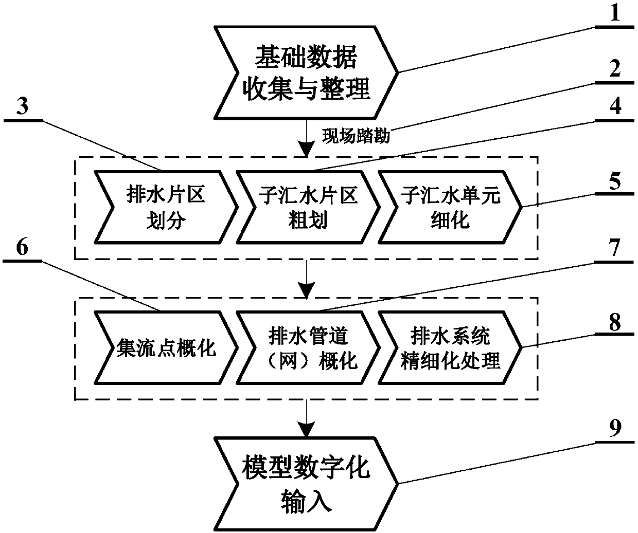
[0028] This embodiment is a case where the model digitization method is applied in the core area of an economic development zone in Beijing, such as figure 1 As shown, the technical process includes: the collection and arrangement of basic data 1, the rationality analysis and review of the basic data is realized with the help of on-site survey 2, and the complex underlying surface of the urban area is divided into drainage areas after preliminary processing 3. The division of the drainage area according to the distribution of land types is the rough planning process of the sub-catchment area. 4. The land types of the sub-catchment area are relatively concentrated but still cannot meet the simulation accuracy. The method for improving the simulation accuracy of the model The sub-catchment unit refinement process 5 can be achieved by further finely dividing the sub-catchment area. The above-mentioned 3-5 processes belong to the refinement treatment process of the water catchmen...
Embodiment 2
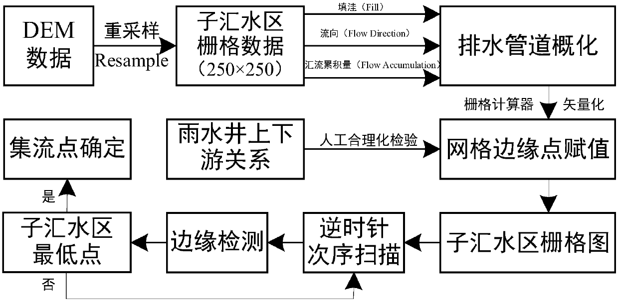
[0035] Such as figure 2 As shown, this embodiment is an improvement of the first embodiment, and it is a refinement of the drainage system of the first embodiment. This embodiment also takes the typical urban area in Embodiment 1 as an example, and the drainage pipes (networks), rainwater wells, and rainwater collection points connect each sub-catchment area together. The drainage pipes in the core area involve 47 different specifications of 4 types of materials such as steel pipes, concrete pipes, reinforced concrete pipes, and ordinary cast iron pipes. The pipe materials will affect the setting of parameters such as the Manning coefficient of the model pipeline. The pipe specifications will be Affects model generalization pipeline shape parameters, etc. In addition, the rivers, ditches, and hardened roads in the core area are unified and generalized into drainage pipelines, and the corresponding attributes are stored in digital format in the GIS.
[0036] On the basis of th...
Embodiment 3
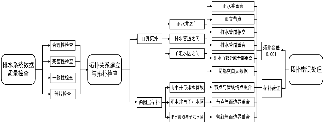
[0038] This embodiment is an improvement of the second embodiment, and is a further refinement of the drainage system in the second embodiment. The refined treatment of the drainage system described in this embodiment also involves topology checking and error handling.
[0039] Such as image 3 As shown, the distributed hydrological model has high requirements for input data. Taking the inspection and correction of the topological relationship of drainage pipes (networks) as an example, the set topology tolerance is 0.001m, and the topological inspection tool in ArcGIS is used first. Preliminary selection of pipe network data, automatic identification and correction of overlapping or unconnected pipe sections, correction of connection errors, overlapping points, lines, and surfaces, and screening of reasonable available pipe networks; then use the pre-running self-check function of the hydrological model , locate the problematic locations of the model topology inspection one ...
PUM
 Abstract
Description
Claims
Application Information