Satellite altimetry gravity data and shipborne measurement gravity data fusion method

A technology of gravity data and satellite altimetry, applied in the application of multi-source marine gravity data fusion, in the field of data fusion, to achieve the effects of rigorous and accurate formula derivation, improved accuracy, and simple and easy-to-understand implementation process

Active Publication Date: 2018-01-16
CHINA UNIV OF PETROLEUM (EAST CHINA)
View PDF5 Cites 4 Cited by
  • Summary
  • Abstract
  • Description
  • Claims
  • Application Information

AI Technical Summary

Problems solved by technology

Generally speaking, the statistical method is widely used, but it also has its shortcomings. The construction of the covariance function is the core issue of the application of the collocation method. Since the establishment of

Method used


Image

  • Satellite altimetry gravity data and shipborne measurement gravity data fusion method
  • Satellite altimetry gravity data and shipborne measurement gravity data fusion method
  • Satellite altimetry gravity data and shipborne measurement gravity data fusion method

Examples


Embodiment Construction

[0050] In order to make the purpose, content, and advantages of the present invention clearer, the specific implementation of the present invention will be described in further detail below with reference to the accompanying drawings and embodiments:

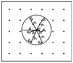
[0051] Reference figure 1 , The specific implementation steps of the present invention are:

[0052] (1) Gravity data G measured by ship 0 As the center, determine the fitting radius S, which is generally 3-5 times the spatial resolution of the satellite altimetry gravity data;

[0053] (2) Gravity data G measured by ship 0 As the center, within the fitting radius S, find n satellite altimetry gravity data points G i (1≤i≤n), and calculate the interpolation weight p of each satellite altimetry gravity data point i , The weight calculation formula is:

[0054]

[0055] In the above formula, p i (1≤i≤n) means the altimetry gravity data of n satellites in the range of S G i (1≤i≤n) corresponding weight, r i (1≤i≤n) is the distance between e...


PUM


Abstract

A satellite altimetry gravity data and shipborne measurement gravity data fusion method disclosed by the present invention comprises the basic steps of determining a fitting radius by taking a shipborne measurement gravity data point as the center; calculating the weights of the satellite altimetry gravity data points within the range of the fitting radius; calculating the interpolation results ofthe satellite altimetry gravity data points at the shipborne measurement gravity data point; calculating the difference values between the interpolation results and the shipborne measurement gravitydata; according to the difference values and the weights, calculating the correction values of the satellite altimetry gravity data points; fusing and calculating to obtain the gravity fusion data. The method provided by the present invention has the advantages of being scientific and reasonable, being easy to realize, being high in precision, etc., and enables the precision of a marine gravity data fusion product to be improved by the satellite altimetry gravity data and shipborne measurement gravity data fusion.

Description

Technical field [0001] The invention relates to the technical field of data fusion, in particular to the application field of multi-source ocean gravity data fusion, specifically a method for fusion of satellite altimetry gravity data and ship gravity data. Background technique [0002] The ocean gravity field can reflect the internal structure of the earth in a wide range of seas. Constructing a precise ocean gravity field and studying its changes will provide important geological data for mankind to solve the increasingly serious problems of resources, environment and natural disasters, as well as geological structure research. , Resource investigation and offshore oil and gas exploration work provide important basis. In addition, gravity anomalies have a great impact on the accuracy of inertial missile hits, and its military significance is particularly significant. [0003] Satellite altimetry gravity has become an important remote sensing data product. Shipborne gravity meas...

Claims


Application Information

Patent Timeline
IPC IPC(8): G01V7/00G01V7/06G01V7/16
Inventor 刘善伟万剑华符艺瀚
Owner CHINA UNIV OF PETROLEUM (EAST CHINA)
Why Eureka
Try Eureka