Quadrotor autonomous obstacle-avoidance unmanned aerial vehicle (UAV) in urban community environment

A UAV, quadrotor technology, applied in three-dimensional position/channel control and other directions, can solve the problem of being easily affected by natural light, and achieve the effect of low power consumption

Pending Publication Date: 2018-01-19
何守印
View PDF3 Cites 21 Cited by
  • Summary
  • Abstract
  • Description
  • Claims
  • Application Information

AI Technical Summary

Problems solved by technology

Passive environmental sensing can obtain environmental depth information, but it is easily affected by natural light, so the combination of active and passive is more popular

Method used


Image

  • Quadrotor autonomous obstacle-avoidance unmanned aerial vehicle (UAV) in urban community environment
  • Quadrotor autonomous obstacle-avoidance unmanned aerial vehicle (UAV) in urban community environment
  • Quadrotor autonomous obstacle-avoidance unmanned aerial vehicle (UAV) in urban community environment

Examples


specific Embodiment

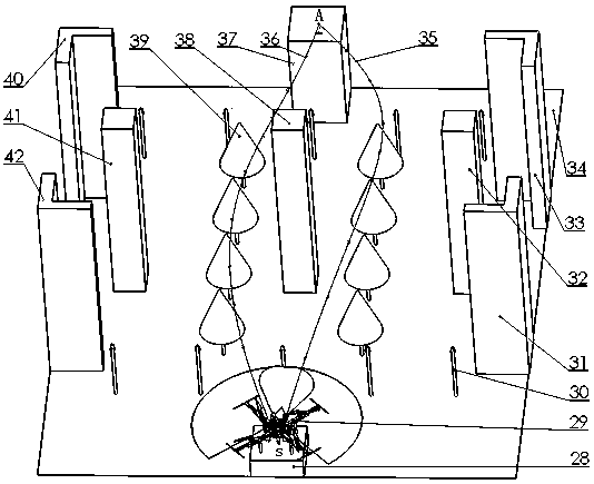
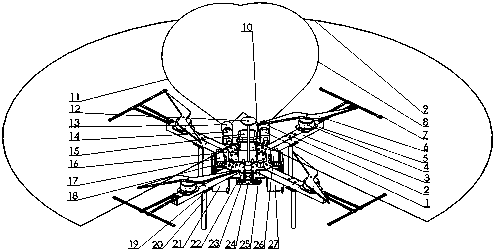
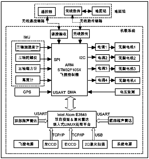
[0039] Such as figure 1 , figure 2 , image 3 , Figure 4 As shown, the four-rotor autonomous obstacle avoidance UAV in the urban community environment combines binocular CCD and 2D laser radar, ultrasonic radar, airborne IMU and GPS and other perception detection, positioning and navigation sensors for the building environment model of the urban community. A three-dimensional obstacle avoidance path planning method for UAVs based on intelligent computing, designed and implemented a quadrotor obstacle avoidance UAV platform based on binocular vision and lidar data airborne real-time online processing, which can meet the needs of unmanned urban community environment space The entire autonomous obstacle avoidance process includes 3D environment perception, multi-sensor information fusion, 3D path planning, and 3D trajectory tracking autonomous control. Below to figure 2 The obstacle avoidance model in the urban community environment is taken as an example to illustrate the...


PUM


Abstract

The invention discloses a quadrotor autonomous obstacle-avoidance unmanned aerial vehicle (UAV) in an urban community environment. The quadrotor autonomous obstacle-avoidance UAV includes an airbornesystem platform, a ground station platform, a data transmission link, an urban community environment model and an intelligent three-dimensional path planning algorithm module based on the urban community environment model. Aimed at the urban community building environment model, by integrating a binocular CCD, a 2D lidar, an ultrasonic radar, an airborne IMU, a GPS and other perceptual detection,positioning navigation sensors, and through a UAV three-dimensional obstacle-avoidance path planning method based on intelligent computing, the invention designs and implements a quadrotor obstacle-avoidance UAV platform based on binocular vision and laser radar data airborne real-time online processing, which can meet the requirements of autonomous obstacle-avoidance flight of the UAV in the urban community environment space and lays a solid foundation for a wide range of applications of intelligentized UAVs to the anti-terrorism, street fighting, battlefield intelligence detection, parcel delivery, power inspection, disaster inspection, natural environment remote sensing and the like.

Description

technical field [0001] The invention relates to a three-dimensional environment perception and multi-sensor information fusion by binocular CCD and 2D laser radar, ultrasonic radar, airborne IMU and GPS and other perception detection and positioning navigation sensors for the urban community building environment, through intelligent three-dimensional path Planning Algorithms for Autonomous Obstacle Avoidance UAVs in Urban Community Environments. Background technique [0002] In recent years, since the rotor UAV can take off and land vertically, can hover at a fixed point in the air, and is not affected by the take-off and landing terrain, with the maturity of control technology, wireless communication technology, and the use of GPS and other navigation systems, especially electronic components With the miniaturization of devices, micro-rotor drones are developing rapidly. Moreover, it has been transferred from military use to civilian use in large quantities. This has brou...

Claims


Application Information

Patent Timeline
Patent Type & Authority Applications(China)
IPC IPC(8): G05D1/10
Inventor 何守印刘凯张立燕
Owner 何守印
Why Eureka
Try Eureka