Spatial relation modeling method for remote sensing image objects

A technology of spatial relationship and remote sensing images, applied in character and pattern recognition, instruments, computer components, etc., can solve problems such as the lack of research on the construction of spatial models of remote sensing image objects, the introduction of object-oriented classification of spatial relationship information without object models, etc. , to achieve the effect of improving classification accuracy and being widely applicable

Active Publication Date: 2018-01-30
INST OF REMOTE SENSING & DIGITAL EARTH CHINESE ACADEMY OF SCI
View PDF1 Cites 5 Cited by
  • Summary
  • Abstract
  • Description
  • Claims
  • Application Information

AI Technical Summary

Problems solved by technology

However, there is currently no research on the construction of spatial models involving remote sensing image objects, and there is no research on introducing the spatial relationship information of object models into object-oriented classification.

Method used


Image

  • Spatial relation modeling method for remote sensing image objects
  • Spatial relation modeling method for remote sensing image objects
  • Spatial relation modeling method for remote sensing image objects

Examples


Embodiment Construction

[0043] The following will clearly and completely describe the technical solutions in the embodiments of the present invention with reference to the accompanying drawings in the embodiments of the present invention. Obviously, the described embodiments are only some, not all, embodiments of the present invention. All other embodiments obtained by persons of ordinary skill in the art based on the embodiments of the present invention belong to the protection scope of the present invention.

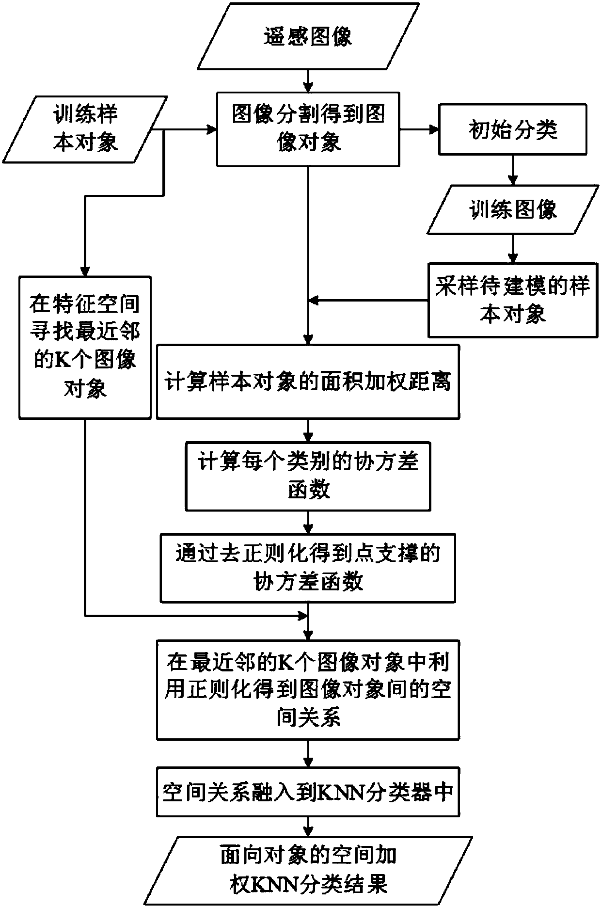
[0044] Such as figure 1 As shown, a classification method based on spatial relationship modeling of remote sensing image objects to which the embodiment of the present invention belongs includes the following steps:

[0045] S1 image segmentation: implement multi-scale segmentation of high-resolution remote sensing images, and segment them into image objects with many homogeneous regions;

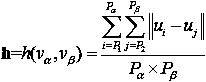
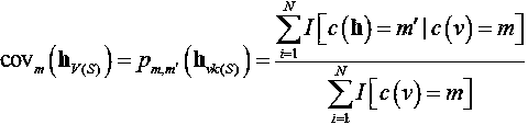
[0046] S2 select training samples: select classified training sample objects according to the characte...


PUM


Abstract

The invention relates to a spatial relation modeling method for remote sensing image objects. The method comprises the steps of S1 image segmentation, S2 training sample selection, S3 initial classification result generating, S4 spatial modeling image sample object selection, S5 calculating of the spatial distance between image sample objects, S6 covariance function estimation of image sample objects, S7 point support model inversion, S8 establishing of spatial relationship between any two image objects, and S9 implementation of object-oriented geostatistical weighted KNN classification method. The method provided by the invention has the advantages that the spatial relation modeling method for the remote sensing image objects is proposed for the first time to fill the gap in the field; compared with a modeling method which does not consider the data characteristics of the image objects, the method effectively improves the classification accuracy; and the method is not limited to the application of the field of remote sensing image classification, and can be widely applied to the modeling of a variety of image objects.

Description

technical field [0001] The invention relates to the technical field of geospatial statistics, in particular to a method for modeling spatial relationships of remote sensing image objects. Background technique [0002] With the popularity of high spatial resolution remote sensing satellites, how to accurately and effectively extract information from the massive data provided by high spatial resolution remote sensing images is the current research focus in the field of remote sensing. The object-oriented analysis method is an analysis method for high-resolution remote sensing images. This method first divides the remote sensing image into individual image objects according to a certain clustering rule, and the homogeneity between each image object is high. The heterogeneity among neighbors is high. The smallest unit of object-oriented analysis is not a single image pixel, but an image object. Not only the spectral information of the object can be used in the analysis, but als...

Claims


Application Information

Patent Timeline
Patent Type & Authority Applications(China)
IPC IPC(8): G06K9/62
Inventor 唐韵玮荆林海张景雄高涵
Owner INST OF REMOTE SENSING & DIGITAL EARTH CHINESE ACADEMY OF SCI
Why Eureka
Try Eureka