Debris flow geological disasters identification method based on remote sensing satellite images

A technology of satellite images and geological disasters, which is applied in the direction of instruments, surveying and mapping and navigation, and measuring devices, etc. It can solve the problems of weather conditions, working conditions, poor living conditions, mud-rock flow disasters cannot be comprehensive, rapid investigation is clear, and on-site investigations are difficult to carry out, etc. problems, to achieve cost-effective and low-cost effects

Active Publication Date: 2018-02-02
GEOVIS CO LTD
View PDF2 Cites 22 Cited by
  • Summary
  • Abstract
  • Description
  • Claims
  • Application Information

AI Technical Summary

Problems solved by technology

Since mudslides mainly occur in mountainous areas, the topography is very complex, and the weather conditions, traffic conditions, working conditions, and living conditions are extremely harsh...

Method used


Image

  • Debris flow geological disasters identification method based on remote sensing satellite images
  • Debris flow geological disasters identification method based on remote sensing satellite images

Examples


Embodiment Construction

[0020] In order to better understand the present invention, the method of the present invention will be further described below with reference to the description of the embodiments in conjunction with the accompanying drawings.

[0021] In the following detailed description, numerous specific details are set forth in order to provide a thorough understanding of the present invention. However, it will be understood by those skilled in the art that the present invention may be practiced without these specific details. In the embodiments, well-known methods, procedures, components have not been described in detail so as not to unnecessarily obscure the embodiments.

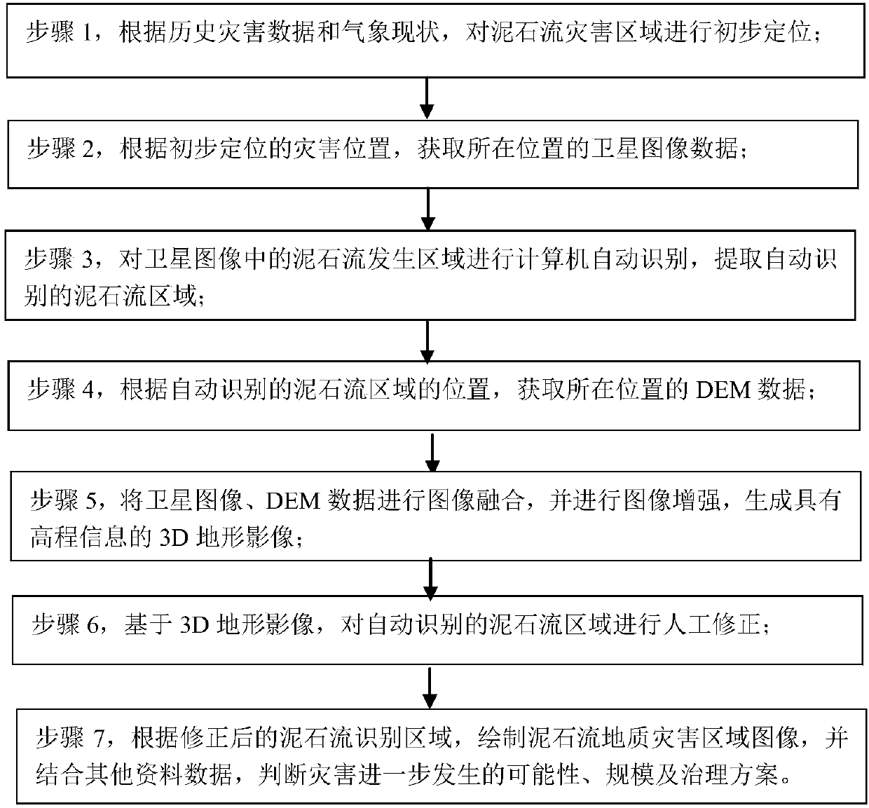
[0022] see figure 1 As shown, the present invention of the present invention provides a kind of debris flow geological disaster identification method based on remote sensing satellite image, it is characterized in that comprising the following steps:

[0023] Step 1. Preliminary positioning of the debris flow disas...


PUM


Abstract

A debris flow geological disasters identification method based on remote sensing satellite images comprises the following steps: carrying out primary localization on debris flow disaster areas according to historical disaster data and current meteorological situations; acquiring satellite image data of the positions according to the primarily located disaster positions; carrying out computer automatic recognition on debris flow areas in the satellite images, and extracting automatically recognized debris flow areas; acquiring DEM data of the positions according to the positions of the automatically recognized debris flow areas; carrying out image fusion on the satellite images and the DEM data, and carrying out image enhancement to generate a 3D terrain image with height information; carrying out manual corrections on the automatically recognized debris flow areas based on the 3D terrain image; drawing a debris flow geological disaster area image according to the corrected debris flowrecognition areas, and judging possibility, scale and treatment scheme of further disasters by combining other data.

Description

[0001] The technology is applicable to the field of geological disaster monitoring, and is specifically a method for identifying debris flow geological disasters based on remote sensing satellite images. Background technique [0002] The impact of debris flow disasters has extended from agriculture to cities, industries, ecological environment and many other fields. Mudflow is a common geological disaster in the Loess Plateau. It erupts suddenly, comes fiercely and quickly, and has strong destructive power. It has caused serious harm to the industrial and agricultural production and people's lives in the Loess Plateau. Sudden mudflows often rush into villages and towns, destroying houses, factories, enterprises and institutions, and various equipment and facilities, and also burying people, animals and farmland, and even causing villages to be destroyed. Imminent monitoring and warning, that is, the forecast within zero hours to several hours, is based on the hourly rainfall m...

Claims


Application Information

Patent Timeline
IPC IPC(8): G01C11/00
CPCG01C11/00
Inventor 谢国钧王猛李宇光
Owner GEOVIS CO LTD
Why Eureka
Try Eureka