Point cloud quality evaluating and unmanned aerial vehicle track planning method for unmanned aerial vehicle scanning reconstruction

A quality evaluation and trajectory planning technology, applied in the field of computer vision, can solve problems such as high failure rate of hole repair, lack of research, large errors, etc., to achieve the effect of reducing the probability of misjudgment, accurate final data, and improving accuracy

Active Publication Date: 2018-03-02
BEIHANG UNIV
View PDF4 Cites 30 Cited by
  • Summary
  • Abstract
  • Description
  • Claims
  • Application Information

AI Technical Summary

Problems solved by technology

Such a repair method is an approximate repair method, and it cannot achieve accurate repair of the hole area missing from the point cloud model.
Moreover, these methods are often accompanied by shortcomings such as low efficiency, large errors, and high failure rate of hole repair in the actual use process.
However, other ideas, such as UAV trajectory planning and point cloud model rescanning to repair holes, are relatively lacking, and other general methods that have significant effects and are widely recognized have not yet emerged.

Method used


Image

  • Point cloud quality evaluating and unmanned aerial vehicle track planning method for unmanned aerial vehicle scanning reconstruction
  • Point cloud quality evaluating and unmanned aerial vehicle track planning method for unmanned aerial vehicle scanning reconstruction
  • Point cloud quality evaluating and unmanned aerial vehicle track planning method for unmanned aerial vehicle scanning reconstruction

Examples


Embodiment Construction

[0077] In order to better understand the technical solution of the present invention, further detailed description will be made below in conjunction with the accompanying drawings and examples.

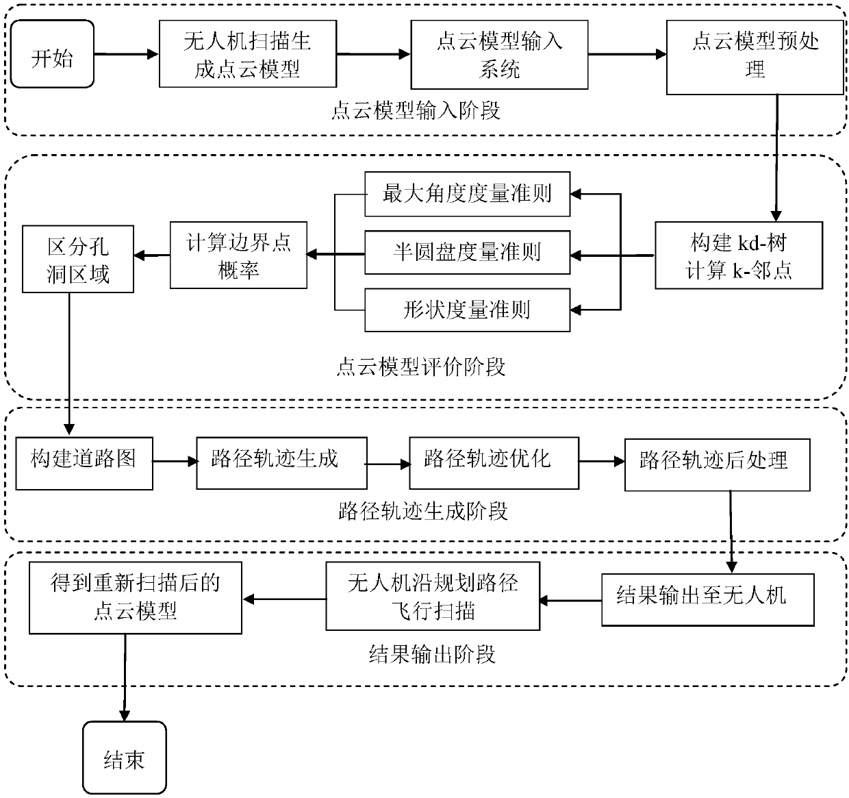
[0078] Such as figure 1 As shown, the present invention proposes a point cloud quality evaluation and UAV trajectory planning method for UAV scanning and reconstruction. figure 1 The schematic flow chart of the method is used to introduce the trajectory planning process of the present invention in detail.

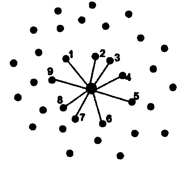
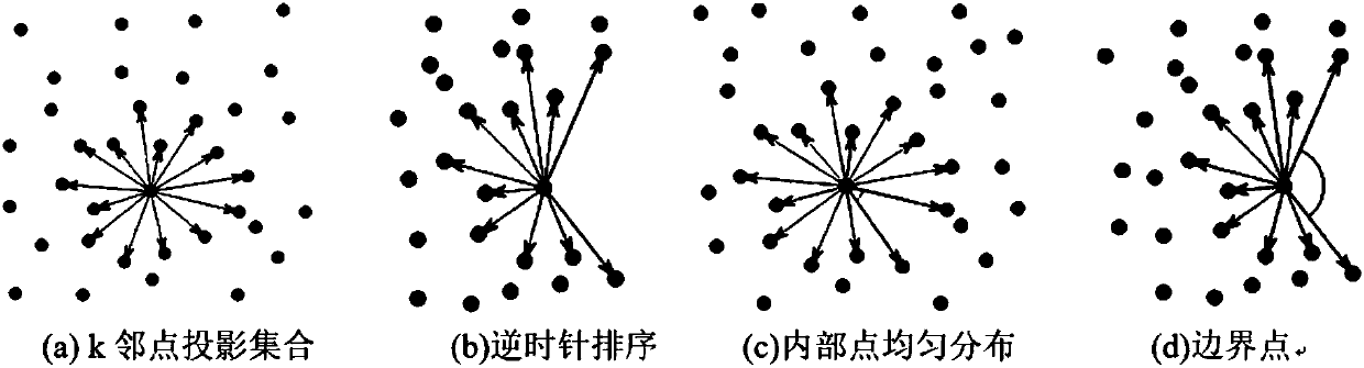
[0079] By evaluating the input point cloud model, find out the hole area that needs to be repaired, and then plan the flight trajectory of the UAV during the repair. The main functions of this method are point cloud model evaluation and path trajectory generation. The evaluation module of the point cloud model is to analyze and evaluate the input point cloud model to find out the hole area with defects; the path trajectory generation module of the UAV is based on the scene inform...


PUM


Abstract

The invention discloses a point cloud quality evaluating and unmanned aerial vehicle (UAV) track planning method for UAV scanning reconstruction, which includes the following steps: the original pointcloud model of a scene is acquired and reconstructed through scanning by a UAV; the points of the point cloud model are classified by using a kd tree; for each point in the point cloud model, the probability that the point is a hole boundary point is estimated based on three criteria respectively, and weighted averaging is carried out on the three probabilities to comprehensively judge whether the point is a hole boundary point; a hole boundary line is generated by searching for closest points, in order to distinguish between different holes; a road map with visibility information is constructed in a point cloud model scene through a ball filling method; an optimal rescanning track of the UAV is generated; and finally, a result is output, a generated path is fed back to the UAV, the UAV flies along the planned path, and the hole area of the point cloud model is repaired. The method can assist an UAV in quickly and automatically rescanning a scene to be reconstructed and generating a more accurate building model, so as to reduce the hole area with texture missing in a building point cloud model.

Description

technical field [0001] The invention belongs to the field of computer vision, and in particular relates to a method for point cloud quality evaluation and UAV trajectory planning for UAV scanning and reconstruction. Background technique [0002] At present, unmanned aerial vehicles, especially small unmanned aerial vehicles, have gradually been widely used in military and civilian applications due to their safety, high mobility, and low cost. The rapid development of drones has made it possible to obtain aerial images efficiently and at low cost. [0003] At the same time, with the development of the times, there are more and more demands for 3D object or scene models. But now most manufacturers represented by Google Earth use 2.5D models obtained from satellite photo modeling, and some important building modeling relies on manual work, which is not only inefficient, but also unsatisfactory in accuracy. If you want to obtain a high-precision, non-artificial 3D model, you c...

Claims


Application Information

Patent Timeline
Patent Type & Authority Applications(China)
IPC IPC(8): G06T17/00G01C21/20
CPCG01C21/20G06T17/00
Inventor 周忠吴威余亦豪闫飞虎
Owner BEIHANG UNIV
Why Eureka
Try Eureka