Object-oriented land cover classification method for coal fire area in high-resolution UAV images

An object-oriented, unmanned aerial vehicle technology, applied in computer parts, instruments, scene recognition, etc., can solve the problems of low classification accuracy, difficulty in distinguishing features in coal fire areas, and difficulty in classifying land cover, and achieves high resolution. High, uniform and rich color, small seam effect

Active Publication Date: 2021-05-18
INST OF DISASTER PREVENTION
View PDF9 Cites 0 Cited by
  • Summary
  • Abstract
  • Description
  • Claims
  • Application Information

AI Technical Summary

Problems solved by technology

Dust pollution in mining areas and the impact of various surface disasters make the surface conditions of coal fire areas in mining areas extremely complicated. Some scholars have used traditional classification methods to carry out land cover classification studies in coal fire areas [8,9] , but it is very difficult to distinguish the ground objects in the coal fire area, the land cover classification is more difficult, and the classification accuracy is low

Method used


Image

  • Object-oriented land cover classification method for coal fire area in high-resolution UAV images
  • Object-oriented land cover classification method for coal fire area in high-resolution UAV images
  • Object-oriented land cover classification method for coal fire area in high-resolution UAV images

Examples


Embodiment Construction

[0033] The present invention will be further described below through specific embodiments and accompanying drawings. The embodiments of the present invention are for better understanding of the present invention by those skilled in the art, and do not limit the present invention in any way.

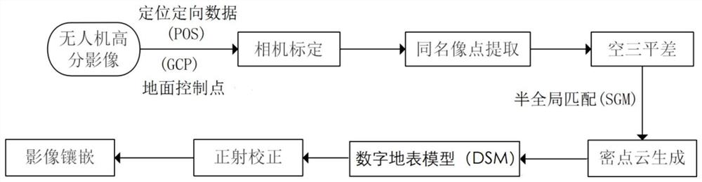
[0034] An object-oriented land cover classification method for coal fire areas with high-resolution UAV images, the specific steps are as follows:

[0035] 1) UAV image acquisition and data processing:

[0036] A four-rotor UAV is equipped with a SONY ILCE-6000 digital camera. The focal length of the digital camera is 20mm, the pixel size is 3.9μm, and the effective pixels are 24 million. There are 4 flight routes, and the flight altitude is 200m. 80% and 60%, a total of 62 true-color images were collected, and 5 aerial survey marker boards were placed in the survey area during the flight, and the center coordinates of the marker boards were measured by RTK as ground control points (GCP)...


PUM


Abstract

The present invention relates to the field of land classification of high-resolution remote sensing images, and in particular to an object-oriented method for classifying land cover of coal-fired areas in high-resolution images of drones. High-resolution color images are divided into homogeneous objects through image multi-scale segmentation algorithms, and an expert knowledge base based on spectral features, shape features, texture features and height information is constructed. Accuracy classification, the classification accuracy is much higher than the traditional pixel-based classification method, and the invention meets the demand for accurate classification of land cover in complex coal fire areas.

Description

technical field [0001] The invention relates to the field of land classification of high-resolution remote sensing images, in particular to an object-oriented method for classifying land cover in coal fire areas with high-resolution images of drones. Background technique [0002] Compared with satellite and airborne remote sensing equipment, UAV, as a new type of remote sensing platform, has the advantages of short flight time, low flight altitude, flexible and convenient operation, low acquisition cost, and high resolution of acquired images. It is a traditional aerial photogrammetry method. It is a beneficial supplement to the system, and is widely used in the fields of topographic map production, disaster emergency management, confirmation of rural land rights, and urban 3D modeling. [1,2] . High-resolution UAV images contain more accurate spatial position information, richer geometric information and texture information, and easier to identify attribute information of g...

Claims


Application Information

Patent Timeline
Patent Type & Authority Patents(China)
IPC IPC(8): G06K9/00G06K9/34G06K9/62
CPCG06V20/13G06V10/267G06F18/241G06F18/214
Inventor 李峰卫爱霞
Owner INST OF DISASTER PREVENTION
Why Eureka
Try Eureka