
Unmanned aerial vehicle remote sensing image segmentation method based on color space classification

A color space and remote sensing image technology, applied in image analysis, image enhancement, image data processing, etc., can solve problems such as low classification accuracy, large salt and pepper noise, and low algorithm efficiency

Inactive Publication Date: 2018-03-09
西安因诺航空科技有限公司
View PDF2 Cites 15 Cited by
  • Summary
  • Abstract
  • Description
  • Claims
  • Application Information

AI Technical Summary

Problems solved by technology

[0007] The purpose of the present invention is to provide a method for segmenting UAV remote sensing images based on color space classification, which solves the problems of low classification accuracy, large salt and pepper noise and low algorithm efficiency in the prior art for high resolution UAV remote sensing images , the invention can quickly and accurately segment high-resolution UAV remote sensing images

Method used


Image

  • Unmanned aerial vehicle remote sensing image segmentation method based on color space classification
  • Unmanned aerial vehicle remote sensing image segmentation method based on color space classification
  • Unmanned aerial vehicle remote sensing image segmentation method based on color space classification

Examples


Embodiment Construction

[0092] The present invention is described in further detail below in conjunction with accompanying drawing:

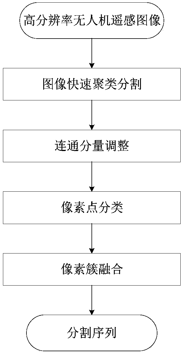
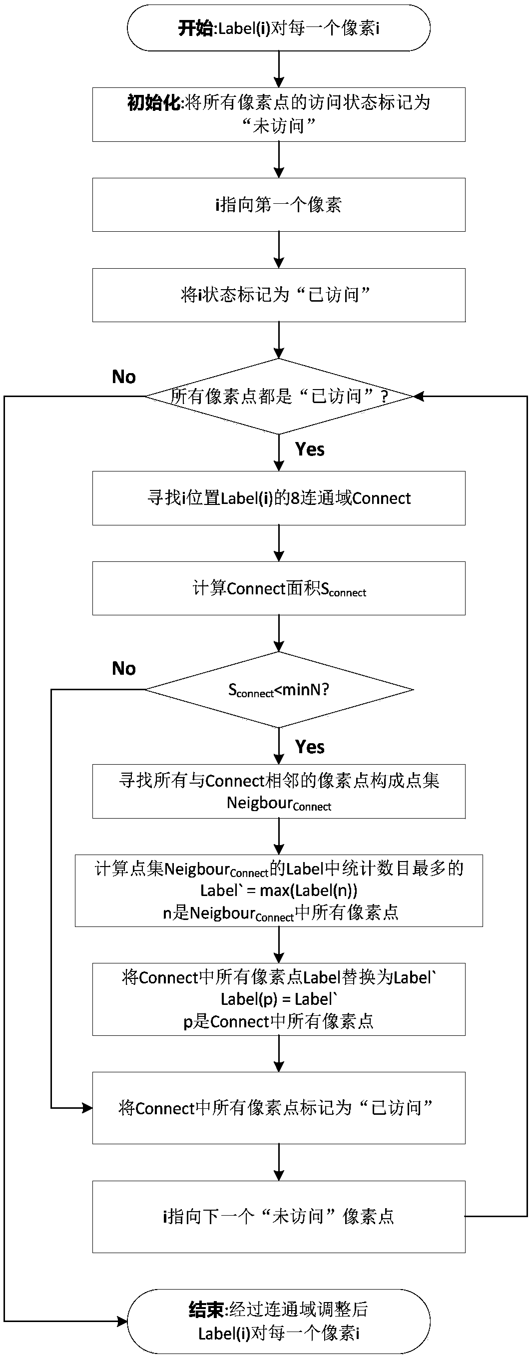
[0093] Such as figure 1 As shown, the present invention provides a method for segmenting UAV remote sensing images based on color space classification. The processing object is high-resolution UAV remote sensing images, specifically including image fast clustering and segmentation, connected component adjustment, pixel classification, Pixel cluster fusion.

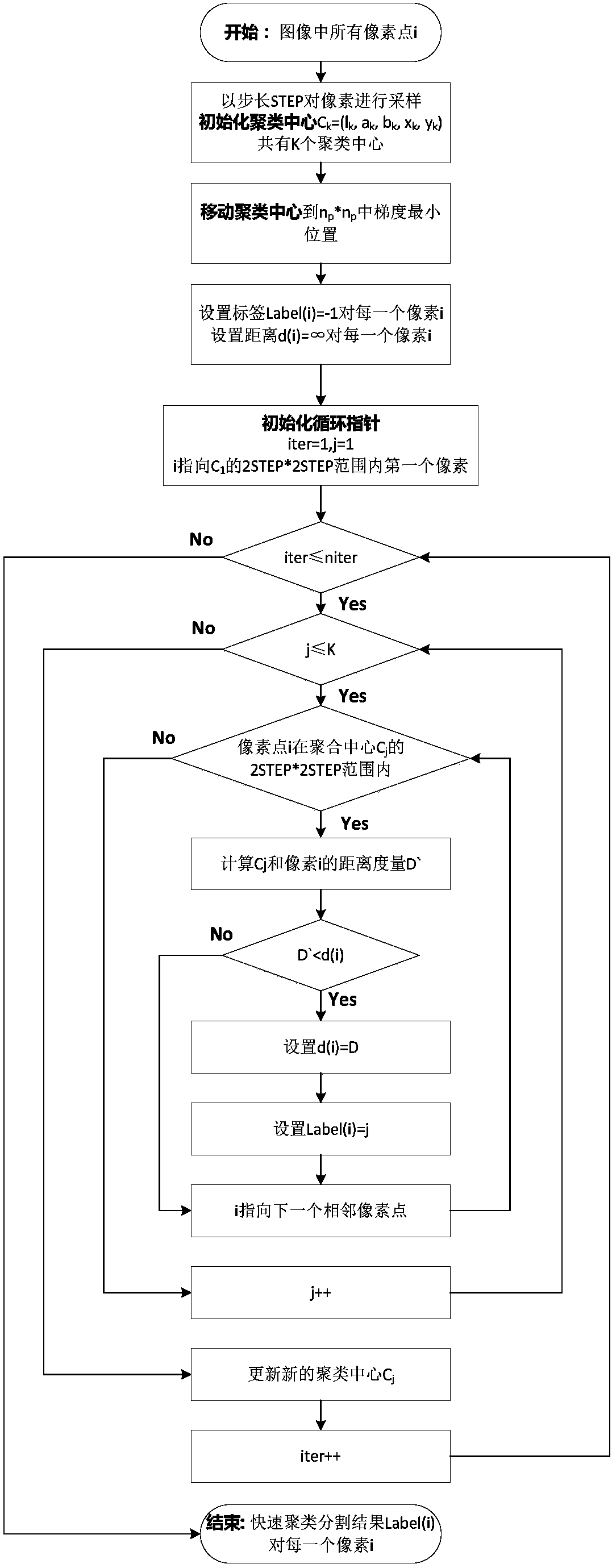
[0094] Step (1), fast image clustering and segmentation:

[0095] Fast image clustering and segmentation is to use the color distance and spatial distance between pixels to judge the similarity of pixels, and to aggregate pixels with high similarity within a certain range (according to the initial clustering center) together, and mark them with the same The cluster center number of the image is divided into a series of small pixel clusters. Such as figure 2 As shown, step (1) specifically includes the followin...


PUM


Abstract

The invention discloses an unmanned aerial vehicle remote sensing image segmentation method based on color space classification. According to the method, a high-resolution unmanned aerial vehicle remote sensing image is divided into a series of pixel clusters. After that, pixel points are classified based on the similarity of color space coordinates and texture features. Finally, the fusion of pixel clusters is guided in combination with the classification result. As a result, it is guaranteed that each partition basically belongs to a homogeneous region. The problems of low classification precision, large pepper salt noise and low algorithm efficiency existing in the prior art are solved. The purpose of quickly and accurately segmenting the high-resolution unmanned aerial vehicle remote sensing image is realized.

Description

technical field [0001] The invention belongs to the technical field of unmanned aerial vehicles, and in particular relates to a method for segmenting remote sensing images of unmanned aerial vehicles based on color space classification. Background technique [0002] At present, obtaining ground thematic information through remote sensing images has become a research and application hotspot in the field of spatial information and related industries. In the past, remote sensing images were obtained mainly through remote sensing satellites and aerial images. Most of the remote sensing images have low resolution, high acquisition cost and limited data volume. The introduction of drones and the generation of high-definition cameras make the acquisition of high-definition remote sensing images more convenient, which also brings a huge demand for information extraction of high-definition remote sensing images. [0003] For the application of UAV remote sensing, the basis and key o...

Claims


Application Information

Patent Timeline
Patent Type & Authority Applications(China)
IPC IPC(8): G06T7/11G06T7/90G06K9/62
CPCG06T7/11G06T7/90G06T2207/10032G06F18/23
Inventor 成凯华白霖抒韩姣姣马泳潮
Owner 西安因诺航空科技有限公司
Learn More