Unmanned aerial vehicle near field guiding system and method

A guidance system and a near-field technology, applied in the application field, can solve the problems of large impact on precise positioning and high technical cost, and achieve the effects of high positioning accuracy, reduced safety risks, and reduced use costs.

Pending Publication Date: 2018-03-20
NANJING WOXU COMM TECH
View PDF11 Cites 18 Cited by
  • Summary
  • Abstract
  • Description
  • Claims
  • Application Information

AI Technical Summary

Problems solved by technology

[0011] The invention proposes a UAV near-field guidance system and method, which solves the technical problems...

Method used


Image

  • Unmanned aerial vehicle near field guiding system and method
  • Unmanned aerial vehicle near field guiding system and method

Examples


Embodiment 1

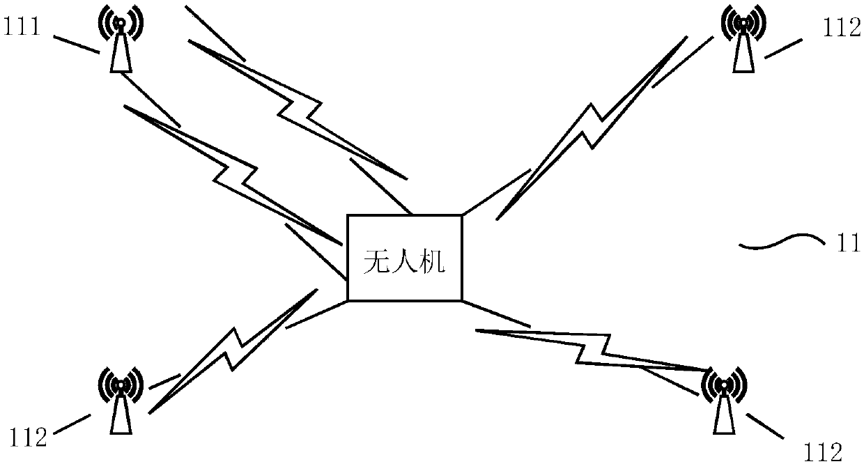
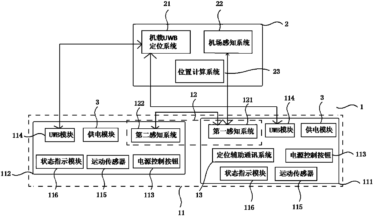
[0145] Build a UAV near-field guidance system: build a UAV near-field guidance system, the master base station 111 and the slave base station 112 perform pairing and cross ranging;

[0146] UAV near-field sensing: the main base station 111 periodically wakes up the first sensing system 121, and after waking up, the first sensing system 121 actively sends a broadcast request message with ID to match with the drone;

[0147] UAV response: the UAV receives the broadcast request message with ID sent by the main base station 111 and performs matching. After the matching is successful, the airport perception system 22 responds to the request message and adds the UAV’s ID to the response message. Relevant information; if the match fails, no response will be given;

[0148] UAV positioning: the first perception system 121 receives the response message from the UAV, the master base station 111 wakes up all the slave base stations 112 on the ground, and the UWB onboard UWB positioning s...

Embodiment 2

[0152] Build a UAV near-field guidance system: build a UAV near-field guidance system, the master base station 111 and the slave base station 112 perform pairing and cross ranging;

[0153] UAV near-field sensing: the main base station 111 periodically wakes up the first sensing system 121, and after waking up, the first sensing system 121 actively sends a broadcast request message with ID to match with the drone;

[0154] UAV response: the UAV receives the broadcast request message with ID sent by the main base station 111 and performs matching. After the matching is successful, the airport perception system 22 responds to the request message and adds the UAV’s ID to the response message. Relevant information; if the match fails, no response will be given;

[0155] Dual-channel authentication: after the main base station 111 obtains the relevant information of the drone through the first perception system 121, it transmits the information of the drone to the server through the ...

Embodiment 3

[0160] Build a UAV near-field guidance system: build a UAV near-field guidance system, the master base station 111 and the slave base station 112 perform pairing and cross ranging;

[0161] UAV near-field sensing: the main base station 111 periodically wakes up the first sensing system 121, and after waking up, the first sensing system 121 actively sends a broadcast request message with ID to match with the drone;

[0162] UAV response: the UAV receives the broadcast request message with ID sent by the main base station 111 and performs matching. After the matching is successful, the airport perception system 22 responds to the request message and adds the UAV’s ID to the response message. Relevant information; if the match fails, no response will be given;

[0163] UAV positioning: the first perception system 121 receives the response message from the UAV, the master base station 111 wakes up all the slave base stations 112 on the ground, and the UWB onboard UWB positioning s...


PUM


Abstract

The invention belongs to the technical field of application such as wireless communication and unmanned aerial vehicle wireless precise positioning and provides an unmanned aerial vehicle near field guiding system. The system comprises a ground system and an onboard positioning system. The ground system comprises an unmanned aerial vehicle near field sensing system and a positioning base station which are connected in sequence. The onboard positioning system comprises an airport sensing system, an onboard UWB positioning system and a position computing system which are connected in sequence. The positioning base station is connected with power supply modules. The positioning base station and the onboard UWB positioning system are in wireless connection. The unmanned aerial vehicle near field sensing system and the airport sensing system are in wireless connection. The positioning base station and a positioning auxiliary communication system are connected. The invention also provides anunmanned aerial vehicle near field guiding method. The system and the method are clever in concept and simple and convenient for operation, and the technical problem that in the prior art, the precise positioning is greatly influenced by an environment and the technical cost is high is solved.

Description

technical field [0001] The invention belongs to the application technical field of wireless communication, UAV wireless precise positioning, etc., and relates to a UAV near-field guidance system and method. Background technique [0002] The precise positioning of drones mainly relies on positioning technologies such as differential GPS and differential Beidou. The positioning accuracy is relatively high, but it is greatly affected by the environment. At the same time, due to network coverage and other factors, not every place can guarantee good positioning accuracy. On this basis, technologies such as visual recognition have been added, and the amount of data processed and the cost have increased significantly. [0003] The most typical defects in the existing system are mainly reflected in the following aspects: [0004] 1. Accurate positioning is greatly affected by the environment [0005] The existing precise positioning mainly relies on the differential system, which...

Claims


Application Information

Patent Timeline
IPC IPC(8): H04W4/029H04W4/40H04W64/00
CPCH04W4/02H04W64/00
Inventor 房宏林权威
Owner NANJING WOXU COMM TECH
Why Eureka
Try Eureka