Method and device for constructing road network of digital map

A digital map and road network technology, applied to maps/plans/charts, instruments, educational tools, etc., can solve problems such as the inability to build a new road network in time, improve route planning efficiency, reduce manual operations, and avoid duplication of work Effect

Active Publication Date: 2018-05-01
武汉四维图新科技有限公司
View PDF10 Cites 2 Cited by
  • Summary
  • Abstract
  • Description
  • Claims
  • Application Information

AI Technical Summary

Problems solved by technology

[0004] Therefore, the technical problem to be solved by the present invention is to overcome the defect in the prior art that a new road network cannot be constructed in time after the road is updated.

Method used


Image

  • Method and device for constructing road network of digital map
  • Method and device for constructing road network of digital map
  • Method and device for constructing road network of digital map

Examples


Embodiment 1

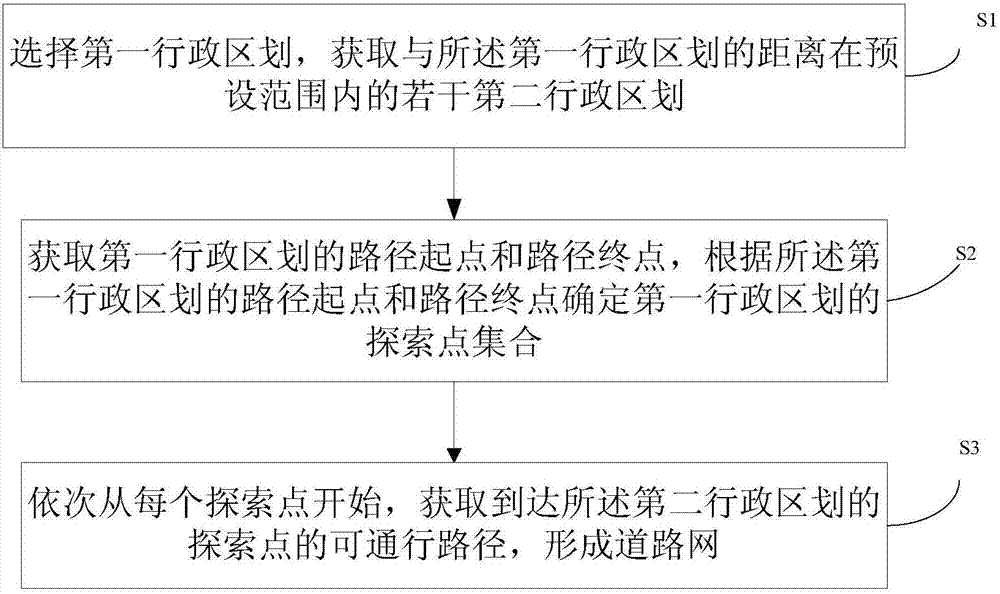
[0028] This embodiment provides a method for constructing a road network of a digital map, which is used in a digital map and can automatically generate a road network between multiple cities to provide a reference for long-distance route planning. The flow chart of the method is as follows figure 1 shown, including the following steps:

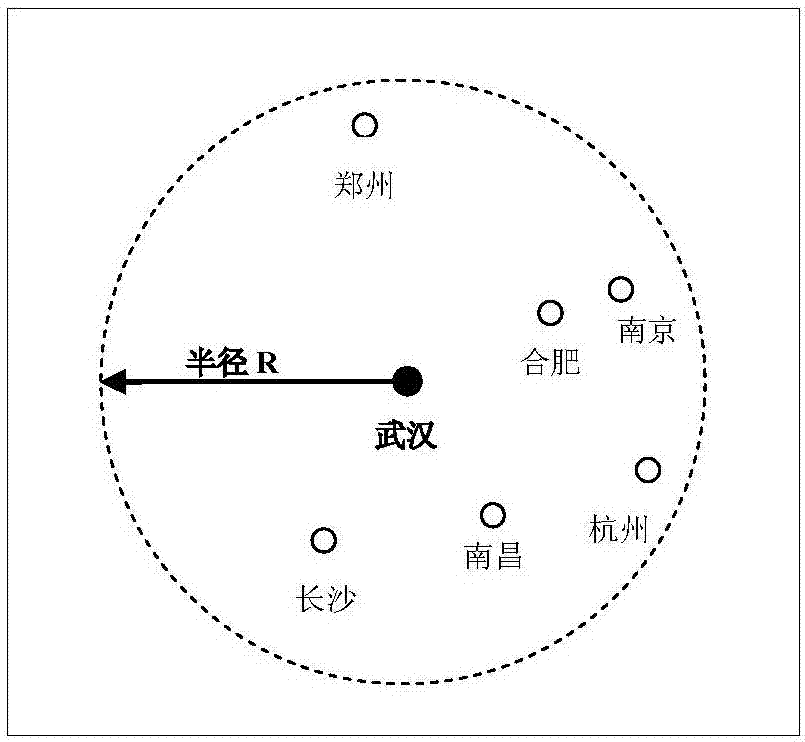
[0029] S1. Select a first administrative division, and acquire several second administrative divisions whose distances to the first administrative division are within a preset range.

[0030] Administrative divisions here generally refer to cities, such as municipalities directly under the central government, provincial capitals, prefecture-level cities, and so on. The center of the administrative division is a central coordinate, but the area contained in the administrative division is generally an irregular range.

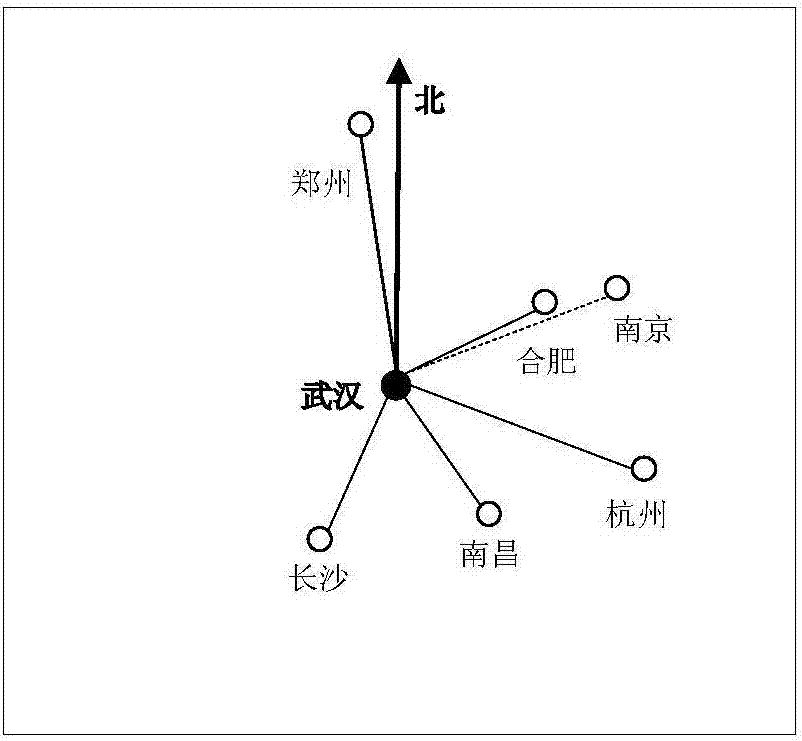
[0031] In the process of acquiring a number of second administrative divisions whose distances from the first administrative ...

Embodiment 2

[0057] In this embodiment, a device for constructing a road network of a digital map is provided, such as Figure 8 shown, including:

[0058] An area selection unit 01, configured to select a first administrative division, and obtain a number of second administrative divisions within a preset distance from the first administrative division;

[0059] An exploration point acquisition unit 02, configured to acquire the starting point and end point of the route of the first administrative division, and determine the set of exploration points of the first administrative division according to the starting point and end point of the route of the first administrative division;

[0060] The road network construction unit 03 is configured to sequentially start from each exploration point, and obtain a passable route to the exploration point of the second administrative division to form a road network.

[0061] Wherein, the area selection unit includes:

[0062] The surrounding admini...


PUM


Abstract

The invention provides a method of constructing a road network of a digital map. Firstly, a first administrative division is selected, and a plurality of second administrative divisions with a presetrange with the first administrative division are acquired; then, the path starting point and the path ending point of the first administrative division are acquired, and according to the path startingpoint and the path ending point of the first administrative division, an exploration point set for the first administrative division is determined; and finally, starting from each exploration point sequentially, passable paths of exploration points reaching the second administrative divisions are acquired to form a road network. In the method, the exploration points are acquired firstly, the paths are then explored based on the exploration points, and a customizable road network is formed. Through adjusting the administrative division number or a connectivity algorithm, the scheme can changethe road network in any region. The obtained road network is combined with a path planning algorithm of a navigator, and the path planning efficiency of the navigator can be improved. Besides, the method can automatically calculate the road network, the manual operation is reduced, and repeated work can be avoided.

Description

technical field [0001] The invention relates to the field of digital maps, in particular to a method and device for constructing a road network of a digital map. Background technique [0002] In the electronic map, after the road is digitized, a line and two nodes are used to represent a road in the real world. The types of roads include highways, national roads, provincial roads, county roads, village roads, and other roads. In a certain area, the interconnected road system composed of various roads forms a road network. The distribution of road network density is reasonable, too much or too little density will reduce the efficiency of path planning. Roads of one or several types of roads form a road network, and the grade of the road network indicates the importance of the road network. [0003] The road network in the navigator generally has multiple layers. From the lower layer to the upper layer, the road network level is getting higher and higher, the importance is ...

Claims


Application Information

Patent Timeline
Patent Type & Authority Applications(China)
IPC IPC(8): G09B29/00
CPCG09B29/006
Inventor 张树清吴中恒胡圣王鹏黄雯雯杨坤
Owner 武汉四维图新科技有限公司
Why Eureka
Try Eureka