Satellite remote sensing product system for agricultural application

A product system and satellite remote sensing technology, applied in the field of satellite remote sensing product systems, can solve problems such as small practical scope, lack of statistical information, and use, and achieve the effect of meeting various needs

Inactive Publication Date: 2018-06-08
BEIJING SATELLITE INFORMATION ENG RES INST
View PDF4 Cites 13 Cited by
  • Summary
  • Abstract
  • Description
  • Claims
  • Application Information

AI Technical Summary

Problems solved by technology

[0003] According to the existing literature, scholars at home and abroad have carried out a lot of research work in various industries such as agriculture, forestry, and water resources by using various satellite remote sensing data. , output thematic map products, lack intuitive statistical information, and cannot be directly used by non-remote sensing professionals, such as industry business personnel; other researchers have established monitoring systems for grassland, forest or agricultural resources, providing online analysis functions for remote sensing thematic products , but most of them are researches on products at a fixed area or county level and at a specific time, and the practical scope is small

Method used


Image

  • Satellite remote sensing product system for agricultural application
  • Satellite remote sensing product system for agricultural application
  • Satellite remote sensing product system for agricultural application

Examples


Embodiment Construction

[0031] The specific implementation manners of the present invention will be further described in detail below in conjunction with the accompanying drawings.

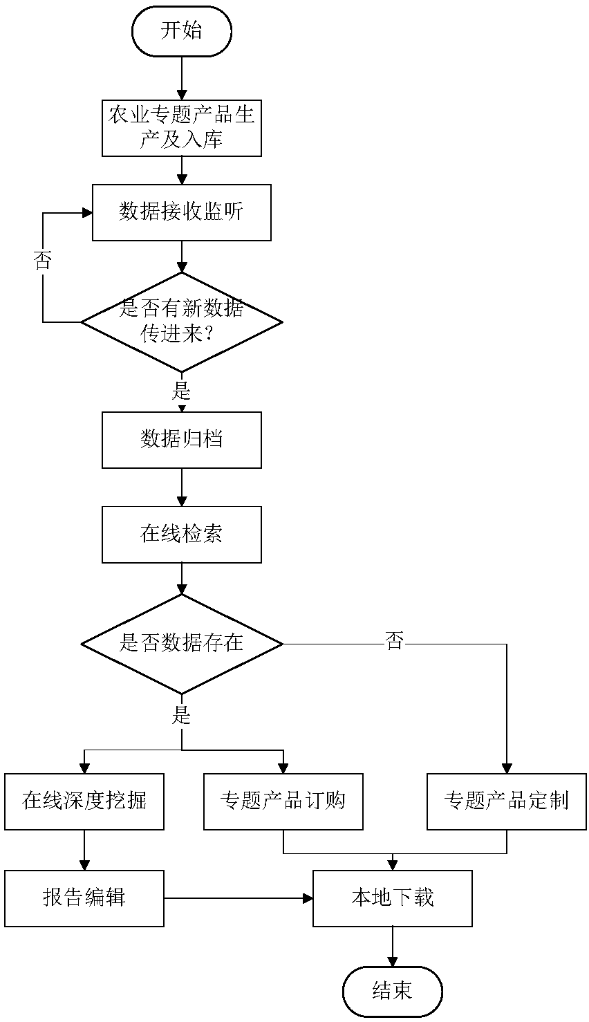
[0032] Such as figure 1 As shown, the present invention designs a satellite remote sensing product system oriented to agricultural applications. In the actual application, it specifically includes the following steps:

[0033] Step A. According to the three categories of agricultural thematic product data, agricultural metadata and agricultural spatial data, enter the agricultural product monitoring data into the system, and then enter step B.

[0034] The agricultural special product data in the above step A mainly receives the produced agricultural special product data, and provides unified storage and management of product data. Data receiving is the beginning of the whole process. Start a data receiving ftpserver to monitor whether there is any data sent. Once new data arrives, first judge whether the current storag...


PUM


Abstract

The invention relates to a satellite remote sensing product system for agricultural application. A professional product production algorithm model is extracted, and archiving, saving and data management are conducted on remote sensing special product data; product online retrieval according to the options such as administrative regions, time, crop types, product types and the like is provided; online in-depth mining of special product information such as planting structures, crop area, real-time growth, process growth, yield of per unit area, total output and the like of soybeans, corns, rice,peanuts and the other crops is provided, and macroscopic remote sensing products adopt quantitative digital expression to visually understand the agricultural situation and development trend in the area-of-interest; operation such as online editing, modification and downloading of reports on statistical special products is provided; in addition, online ordering and customization services for industry specific products are provided, and multiaspect requirements for data are provided.

Description

technical field [0001] The invention relates to a satellite remote sensing product system for agricultural applications, and belongs to the technical field of online service of satellite remote sensing products. Background technique [0002] With the rapid development of network technology in the 20th century, Internet technology has penetrated into all walks of life at a rapid speed, the continuous development of Intenet technology and people's demand for geographic information system (GIS), using Internet to publish and publish spatial data on the Web , to provide users with spatial data browsing, query and online analysis functions, has become an inevitable trend in the development of GIS. As the monitoring and inversion capabilities of remote sensing special products are gradually provided, many researchers currently rely on the advantages of WebGIS and use database technology combined with spatial data engine technology to comprehensively manage information such as remo...

Claims


Application Information

Patent Timeline
Patent Type & Authority Applications(China)
IPC IPC(8): G06F17/30G06K9/00G06Q50/02
CPCG06F16/2465G06F16/29G06Q50/02G06V20/188
Inventor 郭会敏高涛丁火平邹同元王玮哲
Owner BEIJING SATELLITE INFORMATION ENG RES INST
Why Eureka
Try Eureka