Flying device surveying and mapping work area planning method and device as well as terminal

A technology for flying devices and operating areas, applied in the field of unmanned aerial vehicles, can solve the problems of increasing resources and costs, inability to plan differently, unfavorable surveying and mapping data analysis, etc., and achieve the effect of solving low surveying and mapping efficiency.

Inactive Publication Date: 2018-06-12
GUANGZHOU XAIRCRAFT TECH CO LTD
View PDF6 Cites 8 Cited by
  • Summary
  • Abstract
  • Description
  • Claims
  • Application Information

AI Technical Summary

Problems solved by technology

However, when it is processed as a regular rectangle for surveying and mapping, it is impossible to make different plans for different terrains, and because there are more areas outside the irregular shape, the efficiency of its surveying and mapping will be reduced, and the resources and costs required for the surveying and mapping process will be huge. It will be greatly improved, and it is not conducive to the analysis of surveying and mapping data in the later stage.

Method used


Image

  • Flying device surveying and mapping work area planning method and device as well as terminal
  • Flying device surveying and mapping work area planning method and device as well as terminal
  • Flying device surveying and mapping work area planning method and device as well as terminal

Examples


Embodiment 1

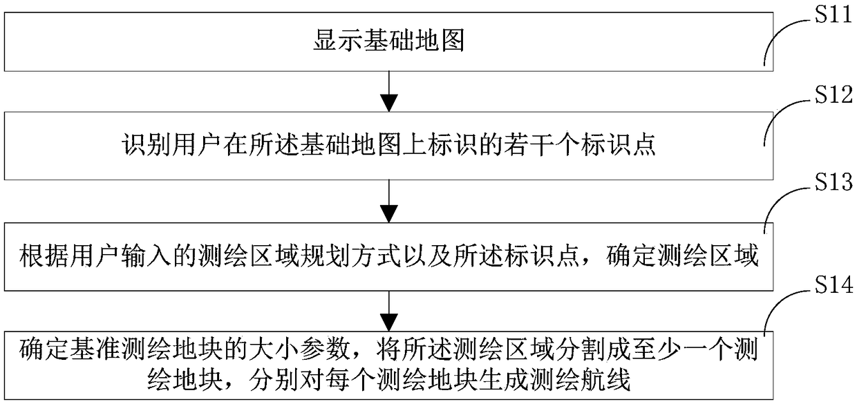
[0088] combine figure 1 , the present embodiment provides a method for planning a flying device surveying and mapping operation area, the subject of which is executed is a terminal, including the following steps:

[0089] S11 displays the base map;

[0090] Wherein, the basic map may be stored in a database, which may be a background database of surveying and mapping operations, which is stored in a server, and the displayed basic map is displayed on a display panel.

[0091] Specifically, steps are also included before this step:

[0092] Create a surveying and mapping job task to trigger a request to obtain the base map in the database. When creating a new task, the user can customize the content of the surveying and mapping job, including the name of the surveying and mapping job, as a piece of navigation information or identification for the newly created surveying and mapping job.

[0093] Of course, the basic map can also be stored in the memory of the terminal, and w...

Embodiment 2

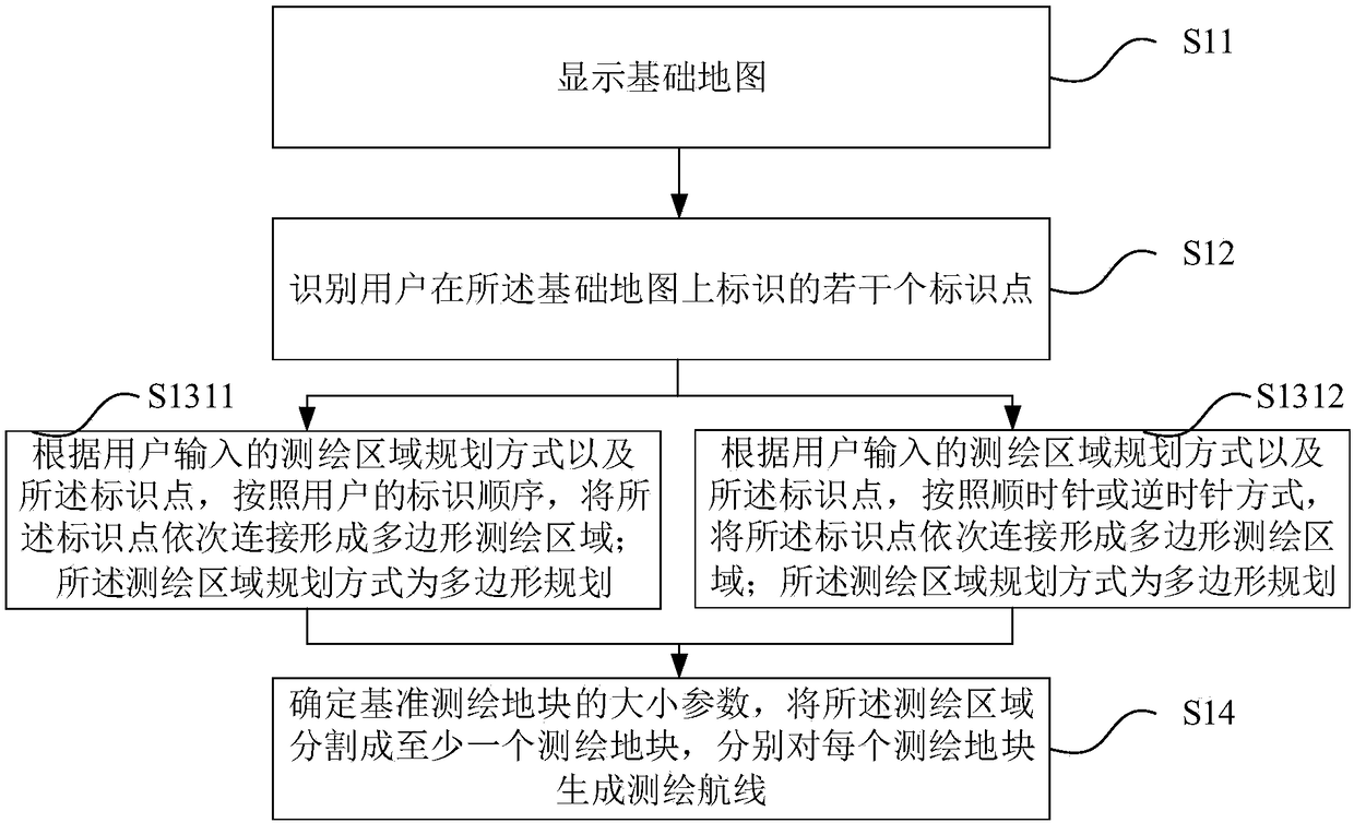
[0143] combine Figure 5 , different from Embodiment 1, this embodiment also provides the following solution:

[0144] The identification of several identification points identified by the user on the basic map includes the steps of:

[0145] S21 Identify several identification points identified by the user on the basic map within the preset identification time period, and judge whether the number of identification points identified within the preset identification time period is greater than the preset identification point threshold;

[0146] In this step, since the several identification points of the identification are based on the touch operation of the user on the display interface, that is, the touch operation received by the display, it is easy to have the problem of user’s accidental touch, so a preset identification time period is set , from the time of the first marker point generated by the user's touch, calculate the preset marker time period, and only identify th...

Embodiment 3

[0155] combine Figure 6 , 7 , 8, the present embodiment also provides a flight device surveying and mapping operation area planning device, including the following modules:

[0156] Display module 31, for displaying the base map;

[0157] An identification module 32, configured to identify several identification points identified by the user on the base map;

[0158] A determining module 33, configured to determine the surveying and mapping area according to the planning mode of the surveying and mapping area input by the user and the identification points;

[0159] The segmentation module 34 is configured to determine the size parameter of the reference surveying plot, divide the surveying area into at least one surveying plot, and generate a surveying route for each surveying plot.

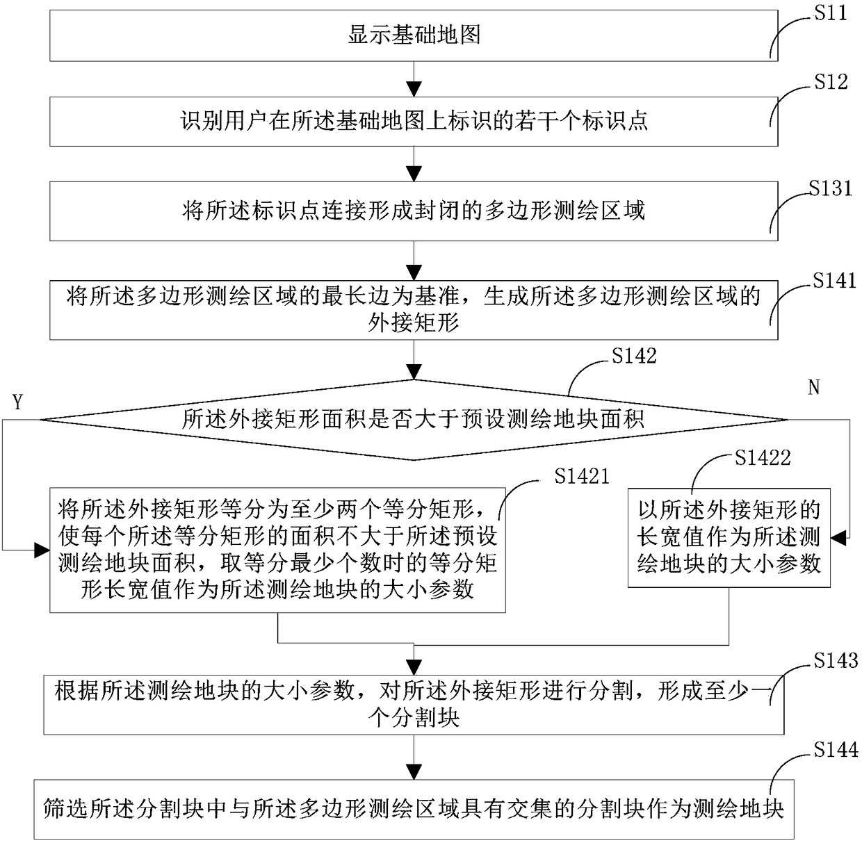
[0160] Wherein, the surveying and mapping area planning method includes polygonal planning and / or linear planning.

[0161] Further, the determination module 33 includes a polygon connectio...


PUM


Abstract

The invention provides a flying device surveying and mapping work area planning method. The flying device surveying and mapping work area planning method comprises the following steps: displaying a base map; identifying a plurality of identification points identified on the base map by a user; according to the surveying and mapping area planning mode and the identification points which are input by the user, determining a surveying and mapping area; determining the size parameter of a base surveying and mapping plot, dividing the surveying and mapping area into at least one surveying and mapping plot and generating a surveying and mapping route on each surveying and mapping plot. Different requirements of the surveying and mapping work are met, different planning modes are provided, and the efficiency of the surveying and mapping work and the user experience are improved. The invention further provides a flying device surveying and mapping work area planning device and a terminal.

Description

technical field [0001] The present invention relates to the technical field of unmanned aerial vehicle, in particular, the present invention relates to a flying device surveying and mapping operation area planning method, device and terminal. Background technique [0002] With the continuous development of surveying and mapping technology, drone surveying and mapping is currently a more commonly used technical means in the field of surveying and mapping. As traditional surveying and mapping are almost all in the state of photogrammetry or small-area high-precision topographic map surveying, they have always relied on manual operations in the field. The shape of the surveying area will not have too much influence on the traditional surveying and mapping. However, when using drones for surveying and mapping, since the surveying and mapping area is generally irregular in polygonal shape or line-shaped, in the prior art, in order to ensure the integrity of the surveying and map...

Claims


Application Information

Patent Timeline
Patent Type & Authority Applications(China)
IPC IPC(8): G01C15/00
CPCG01C15/00
Inventor 刘杰
Owner GUANGZHOU XAIRCRAFT TECH CO LTD
Why Eureka
Try Eureka