
Three-dimensional drilling mineral mapping method based on rock core hyperspectral scanning image

A technology of hyperspectral images and scanned images, which is applied in the field of 3D mineral mapping of boreholes based on hyperspectral scanning images of cores, can solve the problems of inability for geologists to start, difficult quantitative analysis, and lack of spatial concepts in 2D images. The effect of geological analysis convenience

Inactive Publication Date: 2018-06-12
BEIJING RES INST OF URANIUM GEOLOGY
View PDF6 Cites 9 Cited by
  • Summary
  • Abstract
  • Description
  • Claims
  • Application Information

AI Technical Summary

Problems solved by technology

However, for the fine mineral mapping results of core images, geologists often have no way to start
On the one hand, the two-dimensional image itself lacks the concept of space. On the other hand, although the results of image filling are detailed, they are scattered and difficult to do quantitative analysis.

Method used


Image

  • Three-dimensional drilling mineral mapping method based on rock core hyperspectral scanning image

Examples


Embodiment Construction

[0029] A method for drilling three-dimensional mineral mapping based on hyperspectral scanning images of rock cores provided by the present invention will be further described in detail below in conjunction with the accompanying drawings and specific embodiments.

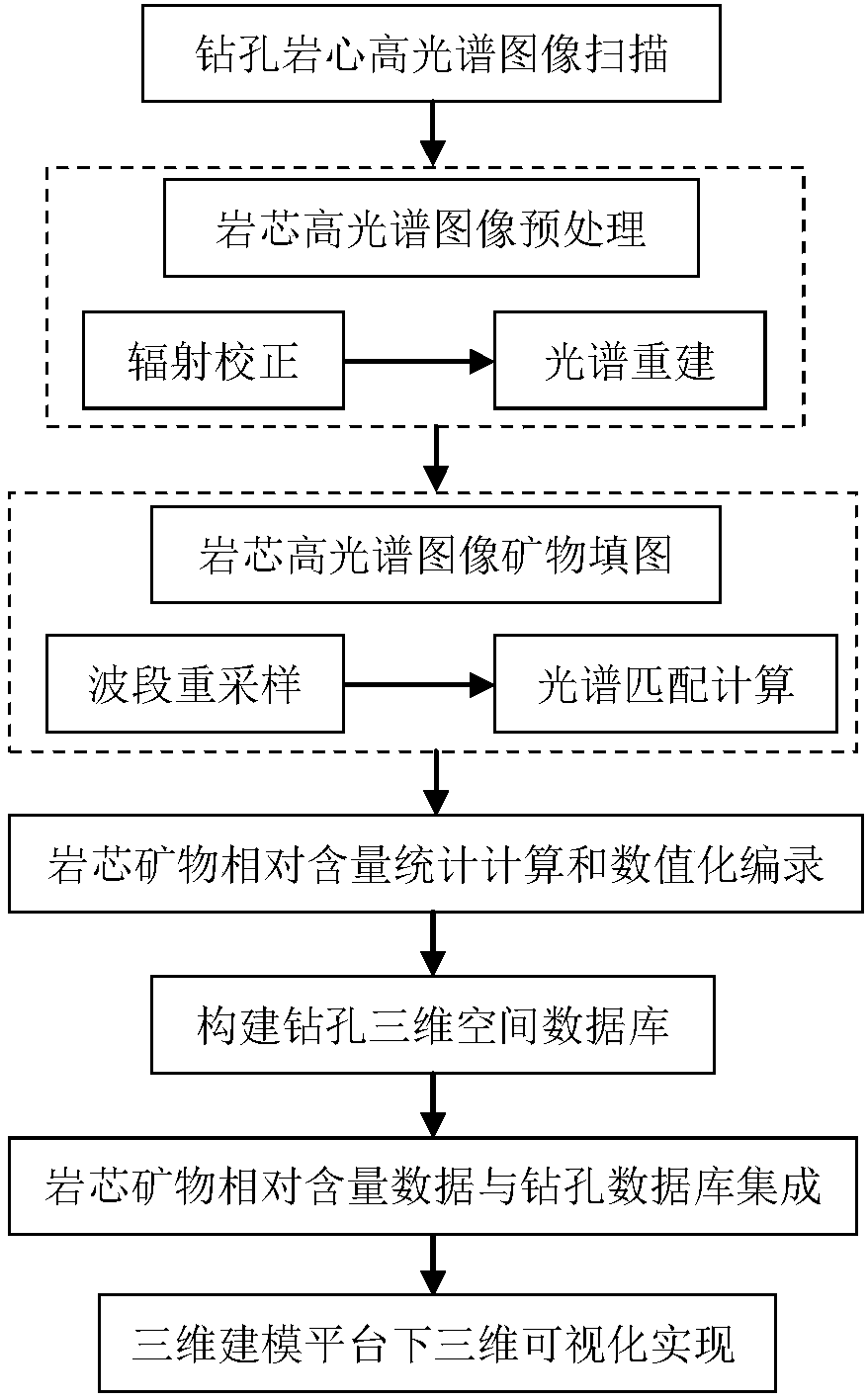
[0030] like figure 1 As shown, the present invention provides a method for drilling three-dimensional mineral mapping based on hyperspectral scanning images of rock cores, comprising the following steps:

[0031] Step 1. Hyperspectral image scanning of drilling core:

[0032] Place the core boxes on the platform one by one, and use Hyspex or other similar ground imaging spectrometers to obtain the hyperspectral image data of the drill core through push-broom scanning according to the unified data acquisition standard.

[0033] During the data collection process, every 0.5 hours, the image data of the standard plate was acquired synchronously, which was used for the spectral reconstruction of the core hyperspectral ...


PUM


Abstract

The invention belongs to the technical field of geological exploration and particularly relates to a three-dimensional drilling mineral mapping method based on a rock core hyperspectral scanning image. The three-dimensional drilling mineral mapping method comprises the following steps: step one, scanning a drilling rock core hyperspectral image; step two, pre-processing the rock core hyperspectralimage; step three, carrying out mineral mapping on the rock core hyperspectral image; step four, carrying out statistical calculation and numerical cataloging on relative content of rock core minerals; step five, constructing a three-dimensional spatial drilling database; step six, integrating relative content data of the rock core minerals with a drilling database; step seven, realizing three-dimensional visualization under a three-dimensional modeling platform. The three-dimensional drilling mineral mapping method has the advantages that various mineral information of drilling rock core development can be quantitatively reflected, and spatial distribution of various minerals can be visually presented in a three-dimensional space, so that geological analysis is better facilitated.

Description

technical field [0001] The invention belongs to the technical field of geological exploration, and in particular relates to a three-dimensional mineral mapping method for boreholes based on hyperspectral scanning images of rock cores. Background technique [0002] At present, in order to study the distribution, zoning and mineral assemblage characteristics of deep alteration minerals, the traditional method is to draw the distribution of mineral categories on the drilling column map through the drilling core catalog of geologists. Core sampling and chemical identification analysis for more refined results. Drilling core records are mostly based on the background knowledge and experience of geological personnel, and are easily affected by subjective factors. Although the results of chemical identification are objective and reliable, they are only the analysis of local samples. [0003] Hyperspectral technology has its unique advantages in mineral identification. Based on the...

Claims


Application Information

Patent Timeline
Patent Type & Authority Applications(China)
IPC IPC(8): G01N21/25
CPCG01N21/25G01N2201/12
Inventor 张川叶发旺车永飞杨旭
Owner BEIJING RES INST OF URANIUM GEOLOGY
Learn More