An Intelligent Obstacle Avoidance System Based on Polar Coordinates

A technology of intelligent obstacle avoidance and polar coordinates, applied in satellite radio beacon positioning system, control/adjustment system, radio wave measurement system, etc., can solve problems such as difficult travel process and bad operation

Inactive Publication Date: 2021-02-09
SHENZHEN JIESIGU TECH
View PDF13 Cites 0 Cited by
  • Summary
  • Abstract
  • Description
  • Claims
  • Application Information

AI Technical Summary

Problems solved by technology

For some people whose self-care ability is not very good, ordinary electric wheelchairs are not easy to operate; for some people with fractures, or some elderly people who go out occasionally, this kind of wheelchair becomes an additional consumption
In addition, for the handicapped, in the process of traveling with mobile tools, it is often difficult to travel because of obstacles encountered. Therefore, it is urgent to develop an intelligent obstacle avoidance system that can be implanted into various mobile tools

Method used


Image

  • An Intelligent Obstacle Avoidance System Based on Polar Coordinates
  • An Intelligent Obstacle Avoidance System Based on Polar Coordinates
  • An Intelligent Obstacle Avoidance System Based on Polar Coordinates

Examples


Embodiment 1

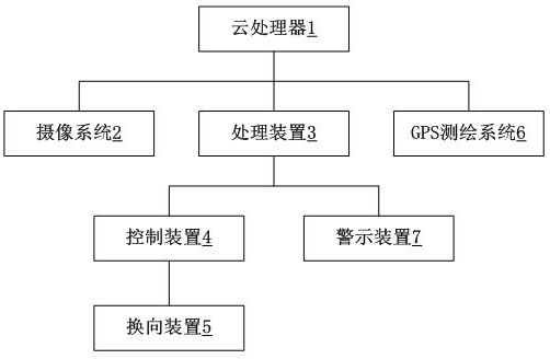
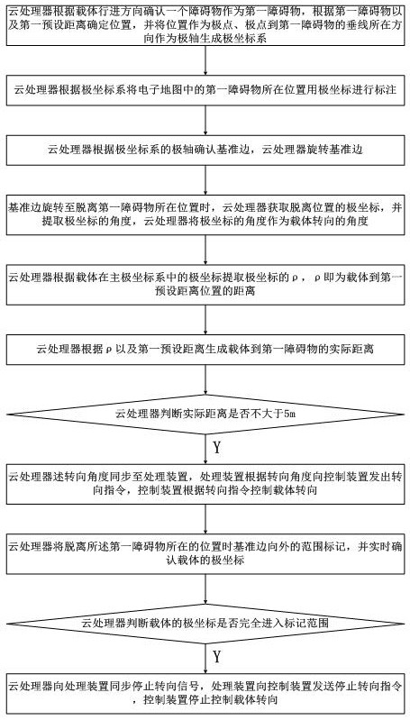
[0027] An intelligent obstacle avoidance system based on polar coordinates, comprising: a cloud processor 1, a camera system 2, a processing device 3, a control device 4, a reversing device 5, a carrier, and the cloud processor 1 is connected to the processing device 3 respectively and camera system 2 data synchronization, the processing device 3 is connected to the camera device and the control device 4 respectively, the carrier carries the processing device 3, the control device 4 and the reversing device 5, and the camera system 2 is used for Shoot the real scene of the street, the cloud processor 1 generates a real-scene electronic map according to the real street scene, the cloud processor 1 judges the first obstacle according to the electronic map, and the cloud processor 1 is provided with a first preset distance, the cloud processor 1 uses the position of the first preset distance as the pole, and the direction of the perpendicular line from the pole to the first obstac...

Embodiment 1

[0036] With regard to Embodiment 1, the difference of this embodiment lies in:

[0037] As a preferred mode of the present invention, the carrier further includes a warning device 7 connected to the processing device 3 .

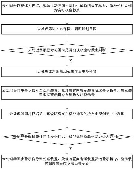
[0038] As a preferred mode of the present invention, the cloud processor 1 forms a new real-time polar coordinate system with the carrier as a pole, the cloud processor 1 is provided with a second preset distance, and the cloud processor 1 is at In the real-time polar coordinate system, it is judged whether there is an object within the range of the second preset distance as the length of ρ, and if so, a warning signal is synchronously sent to the processing device 3, and the processing device 3 sends a warning signal to all objects according to the warning signal. The warning device 7 sends a warning instruction, and the warning device 7 emits a warning sound.

[0039] As a preferred mode of the present invention, the cloud processor 1 confirms a range at ...

Embodiment 3

[0044] With regard to Embodiment 1, the difference of this embodiment lies in:

[0045] As a preferred mode of the present invention, when the cloud processor 1 judges that there are obstacles within the range of the first obstacle, the cloud processor 1 selects the second obstacle after confirming the polar coordinate angle, And the range where the second obstacle is located is marked with polar coordinates, and the second obstacle is the obstacle closest to the first obstacle.

[0046] As a preferred mode of the present invention, the cloud processor 1 extracts the polar coordinates at which the traveling direction of the carrier has just entered the range where the second obstacle is located, and synchronizes the polar coordinate angles to the processing device 3, The cloud processor 1 generates an angle range for the carrier to turn according to the first obstacle polar coordinate angle and the second obstacle polar coordinate angle.

[0047] In the specific implementatio...


PUM


Abstract

The invention relates to an intelligent obstacle avoidance system based on polar coordinates, including: a cloud processor, a camera system, a processing device, a control device, a reversing device, and a carrier, and the cloud processor is respectively synchronized with the processing device and the data of the camera system, and the processing device Connect with the camera device and the control device respectively, the carrier is equipped with the processing device, the control device and the reversing device, the camera system is used to shoot the real scene of the street, the cloud processor generates a real-scene electronic map according to the real street scene, and the cloud processor judges the first obstacle based on the electronic map Object, the first preset distance is set in the cloud processor, the cloud processor takes the position of the first preset distance as the pole, and the ray consistent with the forward direction of the carrier as the polar axis to generate the main polar coordinate system, and the first obstacle The range is marked in the form of polar coordinates, and the cloud processor extracts the polar coordinates whose travel direction is completely away from the range where the first obstacle is located, and synchronizes the polar coordinate angles to the processing device.

Description

technical field [0001] The invention relates to the field of intelligent control, in particular to an intelligent obstacle avoidance system based on polar coordinates. Background technique [0002] With the development and progress of social civilization, ensuring and improving the quality of life of vulnerable groups such as the elderly and the disabled has received more and more attention from the society. A large number of studies have shown that effectively enhancing the mobility of the elderly and the disabled not only facilitates their daily life, but also has a profound impact on their mental health, self-evaluation, and mental state. Therefore, a kind of walking-replacing wheelchair that provides convenience for above-mentioned crowd arises at the historic moment. Traditional wheelchairs are manual, and people turn the handwheels to advance, which requires a lot of physical strength and is not suitable for the elderly and disabled people. Nowadays, there are electr...

Claims


Application Information

Patent Timeline
Patent Type & Authority Patents(China)
IPC IPC(8): G05D1/02G01S19/13
CPCG01S19/13G05D1/0253G05D1/0276G05D1/0278G05D2201/02
Inventor 吴静
Owner SHENZHEN JIESIGU TECH
Why Eureka
Try Eureka