Geographic information data acquisition method, device and system

A technology of geographic information data and collection method, applied in the field of geographic information data collection methods and devices, can solve the problems affecting the timeliness of geographic information data update, affecting the coverage of geographic information data collection, and insufficient coverage, etc. Data collection cycle, improve data collection efficiency, and save labor costs

Inactive Publication Date: 2018-07-13
NAVINFO
9 Cites 12 Cited by

AI-Extracted Technical Summary

Problems solved by technology

[0004] The inventors of the present invention have found that the current geographic information data collection methods have at least the following two defects: on the one hand, due to the limited number of collectors, the coverage of geographic information data coll...

Abstract

The embodiment of the application discloses a geographic information data acquisition method and device. The method comprises the steps that: mobile acquisition equipment records driving data in realtime, and extracts the corresponding driving data and sends the corresponding driving data to a server when a user acquisition instruction is received and/or a preset automatic acquisition condition is met, so that the server carries out updating on current map data according to the received driving data; and correspondingly, the server receives the driving data sent by the mobile acquisition equipment, and carries out updating on the current map data according to the driving data after determining that the driving data is qualified data. Therefore, a coverage range of geographic information data acquisition can be improved, and acquisition efficiency can be improved.

Application Domain

Technology Topic

Image

  • Geographic information data acquisition method, device and system
  • Geographic information data acquisition method, device and system
  • Geographic information data acquisition method, device and system

Examples

  • Experimental program(1)

Example Embodiment

[0017] The technical solutions in the embodiments of the present application will be described clearly and completely in conjunction with the accompanying drawings in the embodiments of the present application. Obviously, the described embodiments are only a part of the embodiments of the present application, rather than all the embodiments. Based on the embodiments in this application, all other embodiments obtained by those of ordinary skill in the art fall within the protection scope of this application.
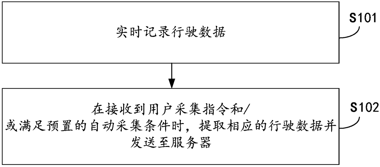
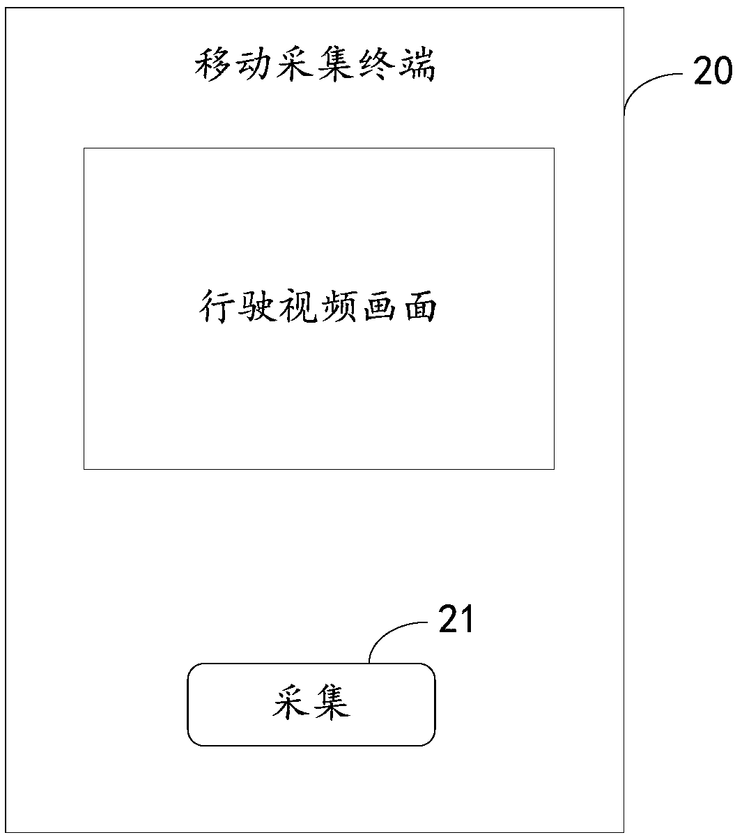
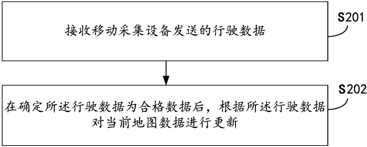
[0018] First of all, it should be noted that in the embodiment of this application, the entities involved mainly include: mobile collection devices (for example, driving recorders, mobile smart terminals, etc.) and their corresponding servers (in this embodiment, the server Can store map data, etc.). In the embodiments of the present application, the entities are independent of each other and cooperate with each other. The specific implementation manner is described in detail below.
[0019] Terminal side method embodiment
[0020] See figure 1 From the perspective of the terminal side, that is, the mobile collection device, this embodiment provides a method for collecting geographic information data. The method includes the following steps:
[0021] S101: Record driving data in real time.
[0022] In this embodiment, the mobile collection device includes, but is not limited to, a driving recorder and a mobile smart terminal. In specific implementation, the mobile collection device can be pre-installed in the vehicle, and the mobile collection device can record the driving data of the vehicle in real time, including real-time shooting of video data during the driving process of the vehicle, and real-time collection of its global positioning system according to the driving route of the vehicle ( GPS, Global Positioning System) data, real-time collection of voice data during driving.
[0023] S102: When a user's collection instruction is received and/or a preset automatic collection condition is met, corresponding driving data is extracted and sent to the server, so that the server can update the current map data according to the received driving data.
[0024] In this embodiment, the collection function can be triggered in the following two situations. The collection function can be to obtain driving data in a corresponding time period or a corresponding geographic range and send it to the server. Here, taking the mobile collection device using the driving record as an example, the two types are described as follows:
[0025] The first case: see figure 2 , Is a schematic diagram of the user actively triggering the collection function. In this embodiment, an operation option 21 (for example, a "collect" button) for receiving collection instructions can be provided in the interface 20 of the mobile collection device related application (APP). When the vehicle is driving, the user finds that the road conditions are different. Change, for example, a traffic light is added to a certain road, a road is added to a certain area, etc., the user can actively trigger the operation option 21, and the mobile collection device can receive the collection from the user through the operation option 21 Instructions, in this case, the driving data within a preset time period can be extracted and sent to the server. The preset time period can be set according to actual needs. In this embodiment, the preset time period may be, for example, driving data recorded 15 minutes before the trigger operation and 15 minutes after the trigger operation.
[0026] That is to say, in the case where the user actively triggers the collection function, the server can receive the driving data recorded within a preset time period (for example, 15 minutes before and after the trigger operation) provided by the mobile collection device according to the user's collection instruction.
[0027] The second case: When the preset automatic acquisition conditions are met, the system automatically triggers the acquisition function. In this case, there are two ways:
[0028] 1) In one method, after the mobile acquisition device records the driving data in real time, the GPS data in the driving data can also be sent to the server in real time.
[0029] When the server receives the GPS data sent by the mobile collection device in real time, it can compare the GPS track composed of the GPS data with the current map data in the server, that is, the GPS data is differentiated from the current map data. The missing part of the data (for example, a missing road) or the part with inconsistent shape (for example, the shape of a road is inconsistent) can be determined as the area where the map data has changed, and the corresponding geofence (Geo- Fencing) information (that is, a virtual geographic boundary is enclosed by a virtual fence), and then the geographic fencing information can be sent to each mobile collection device.
[0030] The mobile collection device can receive and store the geofence information sent by the server.
[0031] Based on this, when the mobile collection device determines whether the current vehicle is within the area corresponding to the geofence information based on the GPS data it collects and the received geofence information, if the current vehicle is currently within the area corresponding to the geofence information When the time, it can meet the preset automatic collection conditions. In this case, the driving data recorded in the area corresponding to the geofence information can be automatically extracted and sent to the server.
[0032] 2) In another way, information related to changes in geographic information can be obtained through the Internet, government agencies, etc., for example, a new expressway is opened in a certain area, a park is added in a certain area, etc. The above-mentioned geographic information change situation determines the change information of the map data, and generates corresponding geofence information, and can send the geofence information to the mobile collection device.
[0033] The mobile collection device can receive and store the geofence information sent by the server. Based on this, when the mobile collection device determines whether the current vehicle is within the area corresponding to the geofence information based on the GPS data it collects and the received geofence information, if the current vehicle is currently within the area corresponding to the geofence information When the time, it can meet the preset automatic collection conditions. In this case, the driving data recorded in the area corresponding to the geofence information can be automatically extracted and sent to the server.
[0034] That is to say, in the case that the system automatically triggers the collection function when the preset automatic collection conditions are met, the server receives the driving data recorded by the mobile collection device in the area corresponding to the geofence information.
[0035] In the case where the user actively triggers the collection function or the system automatically triggers the collection function when the preset automatic collection conditions are met, it can help the server to receive the above-mentioned changed geographic information data that needs to be updated from the mobile collection device in time. .
[0036] After the server receives the above-mentioned driving data sent by the mobile collection device, it can further determine whether the received driving data is qualified data. If it is qualified data, it can perform operations such as updating the current map data according to the driving data. If it is unqualified data, it can be discarded and continue to wait for receiving qualified data.
[0037] In practical applications, determining whether the driving data is qualified data, for example, may include: determining whether the GPS trajectory composed of GPS data is clear and continuous, if the GPS trajectory is clear and continuous, it is qualified data, so that The missing or inconsistent parts of the map are effectively updated; determine whether the video data is clear, if the video data is clear, it is qualified data, so that the scene in the video can be clearly identified. In addition, it can be determined whether the GPS data is repeated data, and if it is not repeated data, it is qualified data.
[0038] After determining that the received driving data is qualified data, the qualified driving data can be input to the relevant data entry platform, so that the data entry platform can update the existing map data in time according to the newly received geographic information data. At the same time, the qualified data can also be marked to identify that the task corresponding to the triggered collection function has ended. There is no need to collect geographic information data within the geographic range corresponding to the qualified data to avoid unnecessary Repeat the operation.
[0039] As an optional implementation, taking the mobile collection device using a smart phone as an example, the above geographic information data collection method is designed as an application, which is configured on the smart phone, and can register and change account information, record and display personal collection results , Sharing, collecting information and interacting, including contribution rankings, simple social functions, such as likes and following. In addition, it can also have payment functions, get rewards or purchase goods, etc.
[0040] According to the above solution in this embodiment, the following advantages can be obtained:
[0041] First, because a large number of operating vehicles can be configured, it is far superior to the existing manual collection methods in terms of range coverage and coverage frequency. For example, according to this embodiment, 300 driving recorders are installed in the city. , Usually one day can cover the entire city once; while the existing manual collection method usually configures about 3 vehicle groups, it can only achieve complete coverage twice a year, and each coverage period is about one month.
[0042] Secondly, based on the above-mentioned higher coverage and frequency, the probability and timeliness of discovering changes in geographic information has also been significantly improved. Third, compared with the existing manual collection method, not only the labor cost is reduced, but also the overall cost is significantly reduced.
[0043] Server side method embodiment
[0044] This embodiment corresponds to the above-mentioned method embodiment on the mobile collection device side, and is a method for processing collected data on the server side. See image 3 , Which is a schematic flow diagram of a geographic information data collection method provided by this embodiment from the perspective of a server, and the method may include the following steps:
[0045] S201: Receive driving data sent by a mobile collection device.
[0046] Wherein, the driving data may include video data, GPS data, and voice data during driving.
[0047] S202: After determining that the driving data is qualified data, update current map data according to the driving data.
[0048] Wherein, determining that the driving data is qualified data may include: determining that the GPS trajectory composed of GPS data is clear and continuous, and determining that the video data is clear, so that the scene situation in the video can be clearly identified.
[0049] In practical applications, in a case where the mobile collection device receives a user collection instruction, S201 may include receiving driving data within a preset time period provided by the mobile collection device according to the user collection instruction.
[0050] In addition, in one case, the server can also receive the GPS data sent by the mobile collection device in real time, compare the GPS data with the current map data to determine the area where the map data is sent and generate the corresponding geofence information, and then Send the geo-fence information to a mobile collection device; in another case, information related to changes in geographic information can be obtained through the Internet, government agencies, etc., for example, a new expressway is opened in a certain area, and a new one is added in a certain area For parks, etc., we can determine map data change information based on the above-mentioned geographic information changes on the server side, and generate corresponding geofence information, and can send the geofence information to mobile collection devices.
[0051] Based on this, S201 may include receiving the driving data of the mobile collection device in the area corresponding to the geofence information.
[0052] Since the method embodiment on the server side corresponds to the method embodiment on the mobile collection device side, the relevant specific implementation can refer to the introduction in the method embodiment on the mobile collection device side, which will not be repeated here.
[0053] The geographic information data collection method provided by the embodiments of the present application can be applied to mobile collection devices and their corresponding servers. The mobile collection device can record driving data in real time, and can receive collection instructions from users and/or meet preset requirements. Under the automatic collection conditions, the relevant driving data is extracted and sent to the server; correspondingly, the server can receive the driving data sent by the mobile collection device, and after determining that the driving data is qualified data, compare the driving data according to the driving data The current map data is updated. In this way, it can replace the existing method of manually collecting geographic information data to use mobile collection equipment installed in vehicles to collect geographic information data. Based on the characteristics of the large number of vehicles on the road and the diversification of driving areas, one On the one hand, it can solve the problem of incomplete coverage of the collection due to the limitation of the number of collectors, and at the same time increase the coverage frequency; on the other hand, it can shorten the data collection period, improve the efficiency of data collection, and improve the update of geographic information data. Timeliness to ensure the freshness of geographic information data; in addition, it can also save labor costs, thereby reducing the cost of the entire data collection work.
[0054] Terminal side device embodiment
[0055] Corresponding to the geographic information data collection method provided in the foregoing embodiment, an embodiment of the present application discloses a geographic information data collection device, which is set on the side of the mobile collection device, see Figure 4 , The device may include: a recording unit 31, a storage unit 32, an acquisition trigger unit 33, and a data extraction unit 34, wherein:
[0056] The recording unit 31 can be used to record driving data in real time. Wherein, the driving data may include video data, GPS data, and voice data during driving.
[0057] The storage unit 32 may be used to store driving data recorded in real time.
[0058] The collection trigger unit 33 can be used to receive user collection instructions and/or monitor whether preset automatic collection conditions are met.
[0059] The data extraction unit 34 may be configured to extract corresponding driving data and send it to the server according to the user collection instruction and/or the preset automatic collection conditions.
[0060] In addition, as an optional implementation manner, the above-mentioned geographic information data collection device may further include: a condition setting unit, and the condition setting unit may be used to preset operation options for receiving a collection instruction. Based on this, the data extraction unit 34 may be further configured to receive a user's collection instruction through the operation option.
[0061] In addition, as an optional implementation manner, the foregoing geographic information data collection device may further include: a first receiving unit, which may be configured to receive the geofence information sent by the server, where the geofence information includes map data Change information. Based on this, the data extraction unit 34 may be further configured to: when it is determined that the current vehicle is within the area corresponding to the geofence information according to the vehicle GPS data and the geofence information, it is determined that the preset automatic collection conditions are met.
[0062] As an optional implementation manner, the foregoing geographic information data collection device may further include:
[0063] The account system is used to register and change account information.
[0064] The collection and recording unit is used to record and display the collection results.
[0065] The information sharing unit is used to share collected information and interact.
[0066] The payment unit is used to realize the payment function.
[0067] The above-mentioned component units of this embodiment can be used as components of an application program installed on the side of the mobile collection device to improve user experience.
[0068] Server side device embodiment
[0069] Corresponding to the geographic information data collection method provided in the foregoing embodiment, an embodiment of the present application also provides a geographic information data collection device, which is set on the server side, see Figure 5 , The device can include the following components:
[0070] The second receiving unit 41 can be used to receive driving data sent by a mobile collection device. Wherein, the driving data may include video data, GPS data, and voice data during driving.
[0071] As an optional implementation manner, the second receiving unit 41 may be further configured to: receive driving data in a preset time period provided by the mobile collection device according to a user collection instruction. Optionally, the second receiving unit 41 may be further configured to receive driving data of the mobile collection device in the area corresponding to the geofence information. Wherein, the mobile collection equipment includes, but is not limited to, a driving recorder and a mobile intelligent terminal.
[0072] As an optional implementation manner, the geographic information data collection device may further include:
[0073] The third receiving unit can be used to receive GPS data sent by the mobile collection device in real time;
[0074] The geofence information generating unit can be used to compare the GPS data with current map data, determine the area where the map data has changed, and generate geofence information, the geofence information including the change information of the current geographic data;
[0075] The geofence information sending unit can be used to push the geofence information to each mobile collection device.
[0076] As an optional implementation manner, the aforementioned geographic information data collection device further includes: a data screening unit 42 which can be used to determine whether the driving data is qualified data according to preset screening conditions.
[0077] The updating unit 43 may be used to update the current map data according to the driving data after determining that the driving data is qualified data. Wherein, the updating unit 43 can be further used to determine that the GPS track composed of GPS data is clear and continuous and that the video data is clear.
[0078] The pushing unit 44 can be used to generate geo-fence information according to the GPS data provided by the mobile collection device, and push it to each mobile collection device.
[0079] The geographic information data collection device provided in the embodiments of the present application can be applied to mobile collection equipment and its corresponding server. The mobile collection equipment can record driving data in real time, and can receive collection instructions from users and/or meet preset requirements. Under the conditions of automatic collection, the corresponding driving data is extracted and sent to the server; accordingly, the server can receive the driving data sent by the mobile collection device, and after determining that the driving data is qualified data, compare the current driving data according to the driving data. The map data is updated. In this way, it can replace the existing method of manually collecting geographic information data to use mobile collection equipment installed in vehicles to collect geographic information data. Based on the characteristics of the large number of vehicles on the road and the diversification of driving areas, one On the one hand, it can solve the problem of incomplete coverage of the collection due to the limitation of the number of collectors, and at the same time increase the coverage frequency; on the other hand, it can shorten the data collection period, improve the efficiency of data collection, and improve the update of geographic information data. Timeliness to ensure the freshness of geographic information data; in addition, it can also save labor costs, thereby reducing the cost of the entire data collection work.
[0080] See Image 6 As shown, in this embodiment, a geographic information data collection system is also proposed, which may include the mobile collection device 50 and the server 60 in any of the above related embodiments, wherein:
[0081] The mobile collection device 50 can be pre-installed in the vehicle, and it can be configured with a geographic information data collection device on the terminal side disclosed in any of the above-mentioned related embodiments, and the server 60 can be configured with the server-side geographic information provided by any of the above-mentioned related embodiments. For the information data collection device, the relevant specific implementation can refer to the introduction in the above-mentioned embodiment, which will not be repeated here.
[0082] From the description of the foregoing implementation manners, it can be known that those skilled in the art can clearly understand that this application can be implemented by means of software plus a necessary general hardware platform. Based on this understanding, the technical solution of this application essentially or the part that contributes to the existing technology can be embodied in the form of a software product, and the computer software product can be stored in a storage medium, such as ROM/RAM, magnetic disk , CD-ROM, etc., including several instructions to make a computer device (which may be a personal computer, a server, or a network device, etc.) execute the methods described in the various embodiments or some parts of the embodiments of this application.
[0083] The various embodiments in this specification are described in a progressive manner, and the same or similar parts between the various embodiments can be referred to each other, and each embodiment focuses on the differences from other embodiments. In particular, as for the system or the system embodiment, since it is basically similar to the method embodiment, the description is relatively simple, and for related parts, please refer to the part of the description of the method embodiment. The system and system embodiments described above are merely illustrative, where the units described as separate components may or may not be physically separated, and the components displayed as units may or may not be physical units, that is It can be located in one place, or it can be distributed to multiple network units. Some or all of the modules may be selected according to actual needs to achieve the objectives of the solutions of the embodiments. Those of ordinary skill in the art can understand and implement it without creative work.
[0084] The geographic information data collection method and device provided by this application are described in detail above. Specific examples are used in this article to illustrate the principles and implementation of this application. The description of the above examples is only used to help understand this application. The method and its core idea; meanwhile, for those of ordinary skill in the art, according to the idea of ​​this application, there will be changes in the specific implementation and the scope of application. In summary, the content of this specification should not be construed as a limitation on this application.

PUM

no PUM

Description & Claims & Application Information

We can also present the details of the Description, Claims and Application information to help users get a comprehensive understanding of the technical details of the patent, such as background art, summary of invention, brief description of drawings, description of embodiments, and other original content. On the other hand, users can also determine the specific scope of protection of the technology through the list of claims; as well as understand the changes in the life cycle of the technology with the presentation of the patent timeline. Login to view more.

Similar technology patents

After-flaming air nozzle arrangement structure

InactiveCN102454982ASuppress generationExpand coverageCombustion apparatusAirflowSmoke
Owner:YANTAI LONGYUAN POWER TECH

Mine mobile object tracking and location method

ActiveCN107437044AExpand coverageIncrease capacity and reliabilityClosed circuit television systemsBiometric pattern recognitionRadio frequencyMobile phone tracking
Owner:CHINA UNIV OF MINING & TECH (BEIJING)

Classification and recommendation of technical efficacy words

  • Improve collection efficiency
  • Expand coverage

Device for collecting spinning dust of spinning machine

Owner:湖州南浔富龙纺织有限公司

Mobile phone network management systems

ActiveUS8364141B1Facilitate rapid accessExpand coverageError preventionTransmission systemsNetwork managementSpatial data structure
Owner:ACTIX
Why Eureka
Try Eureka