Straw incineration fire point remote sensing monitoring method based on FY-3 satellite

A Fengyun No. 3, remote sensing monitoring technology, applied to instruments, character and pattern recognition, scene recognition, etc., can solve problems such as data quality degradation, time distribution concentration, and impact on monitoring and early warning work, so as to enhance supervision capabilities and improve time frequency Effect

Inactive Publication Date: 2018-07-20
NO 27 RES INST CHINA ELECTRONICS TECH GRP
View PDF2 Cites 6 Cited by
  • Summary
  • Abstract
  • Description
  • Claims
  • Application Information

AI Technical Summary

Problems solved by technology

However, excessive reliance on foreign remote sensing data has certain risks and limitations, and the lack of autonomy in the temporal and spatial distribution of data will greatly affect the monitoring and early warning work; in addition, commonly used satellites such as Terra, Aqua, and NOAA are generally in service Problems with longer times, reduced data quality, and concentrated time distribution

Method used


Image

  • Straw incineration fire point remote sensing monitoring method based on FY-3 satellite
  • Straw incineration fire point remote sensing monitoring method based on FY-3 satellite
  • Straw incineration fire point remote sensing monitoring method based on FY-3 satellite

Examples


Embodiment Construction

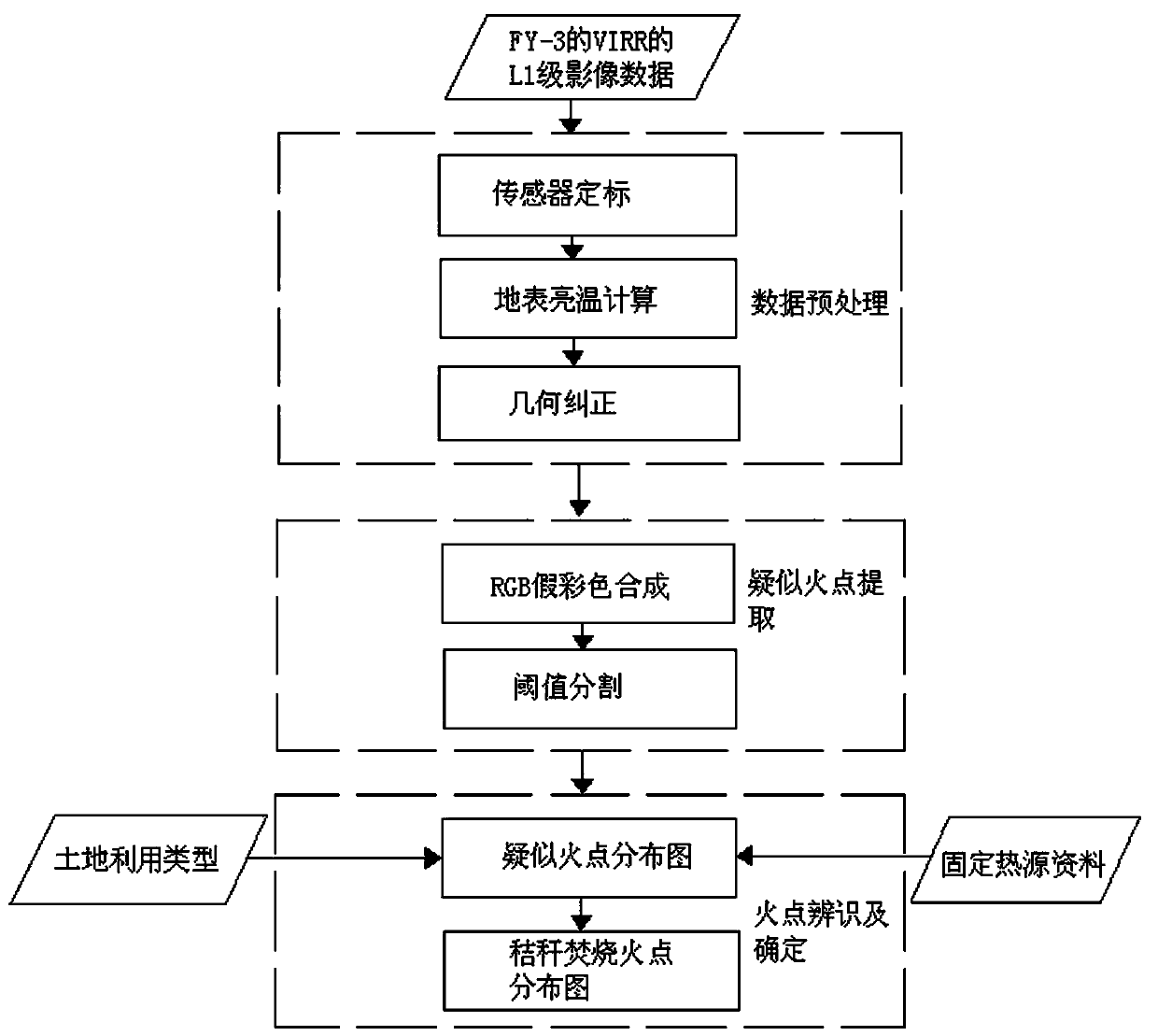
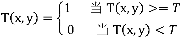
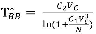
[0040] Such as figure 1 As shown, a remote sensing monitoring method for fire point of straw burning based on FY-3 satellite includes the following steps:

[0041] Step A: data preprocessing of Fengyun No. 3 satellite (FY-3); the Visible Infrared Scanning Radiometer (VIRR) is loaded on Fengyun No. 3 satellite, and the Visible Infrared Scanning Radiometer includes channel one, channel two, channel three, Channel 4, Channel 5, Channel 6, Channel 7, Channel 8, Channel 9, and Channel 10 have a total of ten observation channels with a resolution of one kilometer. The channels 1, 2, 6, 7, 8, and 9 Channel 3, channel 4 and channel 5 are infrared channels. The center wavelengths of channel 3, channel 4 and channel 5 are around 4 μm, 11 μm and 12 μm, which are sensitive to changes in the radiation of the underlying surface; 2. The image data of channel 3, channel 4, channel 5, channel 6, channel 7, channel 8, channel 9 and channel 10 together constitute the L1 level image data of the ...


PUM


Abstract

The invention discloses a straw incineration fire point remote sensing monitoring method based on the FY-3 satellite. The method includes the steps of firstly, preprocessing the L1-level image data ofa visible and infrared radiometer in the FY-3 satellite, then extracting suspected fire points on the basis of the preprocessed image data to obtain a suspected fire point distribution diagram, and finally removing pseudo-fire points according to the land utilization type of the fire point pixel and inquiry of fixed heat source data, separating straw burning fire points from the suspected fire point distribution diagram. The characteristic parameters of the FY-3 satellite and wave band setting of a visible and infrared radiometer (VIRR) loaded on the FY-3 satellite are fully studied, so thatthe remote sensing data of the domestic FY-3 satellite can be used for conveniently, effectively and continuously monitoring the straw burning fire points. The existing common foreign satellite strawburning monitoring results can be verified and supplemented, the time frequency of straw burning monitoring in china is greatly improved, and the supervision capability of straw burning control is effectively enhanced.

Description

technical field [0001] The invention relates to the technical field of straw burning fire point monitoring, in particular to a remote sensing monitoring method for straw burning fire point based on Fengyun-3 satellite. Background technique [0002] For a long time, the pollution prevention and control of straw burning has been one of the important tasks of environmental protection; a large amount of gaseous pollutants and particulate matter will be released during the open-air burning of straw, which will cause certain pollution to the atmospheric environment; large-scale and high-intensity straw burning events will cause atmospheric pollution. The sharp decline in visibility increases the probability of hazy weather and endangers people's health and traffic safety. [0003] However, the current monitoring of straw burning is mainly based on manual means, which cannot fully reach the level of information-based monitoring and management; in many villages in China, the governm...

Claims


Application Information

Patent Timeline
IPC IPC(8): G06K9/00G06K9/34G06K9/36
CPCG06V20/13G06V10/20G06V10/247G06V10/267
Inventor 赵辉杰吴锋王玉玺吴永欣张帅
Owner NO 27 RES INST CHINA ELECTRONICS TECH GRP
Why Eureka
Try Eureka