Method and system for analyzing urban wetland heat island effect based on multi-source remote-sensing image

A technology of heat island effect and analysis method, applied in image analysis, image enhancement, image data processing and other directions, can solve problems such as instability of results

Inactive Publication Date: 2018-07-24
CHINA UNIV OF GEOSCIENCES (WUHAN)
View PDF1 Cites 12 Cited by
  • Summary
  • Abstract
  • Description
  • Claims
  • Application Information

AI Technical Summary

Problems solved by technology

[0003] In previous studies, the analysis of the relationship between wetland landscape pattern, vegetation coverage, leaf ar...

Method used


Image

  • Method and system for analyzing urban wetland heat island effect based on multi-source remote-sensing image
  • Method and system for analyzing urban wetland heat island effect based on multi-source remote-sensing image
  • Method and system for analyzing urban wetland heat island effect based on multi-source remote-sensing image

Examples


Embodiment Construction

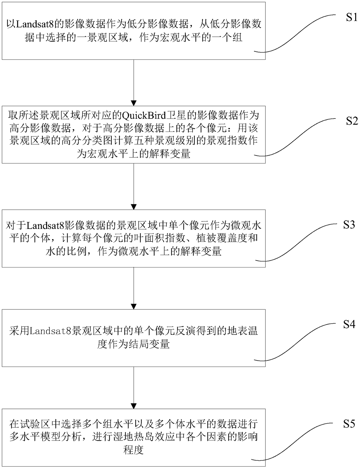
[0042] In order to have a clearer understanding of the technical features, purposes and effects of the present invention, the specific implementation manners of the present invention will now be described in detail with reference to the accompanying drawings.

[0043] refer to figure 1 , this example uses multi-source remote sensing data to analyze the mitigation effect of wetland landscape on the heat island effect. The specific steps are as follows:

[0044] S1. Select a 5*5 landscape area on the Landsat8 image as a macro level group. The resolution of the Landsat8 image is smaller than the image data acquired by the QuickBird satellite described below, and the two form two high-resolution and low-resolution image data.

[0045] S2. Use the QuickBird satellite to obtain the high-score images corresponding to the above-mentioned landscape areas, each pixel on the high-score image data, and use the high-score classification map of the landscape area to calculate the landscape...


PUM


Abstract

A method and system for analyzing an urban wetland heat island effect based on a multi-source remote-sensing image. The method comprises using a Landsat8 image data as low-resolution image data, selecting a landscape area therefrom as a group at a macroscopic level; obtaining the image data of a QuickBird satellite corresponding to the landscape area as high-resolution image data, for each pixelon the high-resolution image data: calculating the landscape index of the landscape level as an explanatory variable at the macroscopic level by using the high-resolution classification map of the landscape area; for a single Landsat8 pixel as an individual at the microscopic level, calculating the explanatory variable at the microscopic level of each pixel; inverting the surface temperature as anoutcome variable by using a single pixel in the Landsat8 landscape area; selecting multiple group level and multiple body level data in the experimental area for multi-level model analysis to analyzethe degree of influence of various factors in the wetland heat island effect. The method and system can simultaneously study the relationship between various factors at the microscopic and macroscopic levels and the surface temperature, and is more accurate and stable in result.

Description

technical field [0001] The invention relates to the analysis of wetland heat island effect, and more specifically relates to a method and system for analyzing urban wetland heat island effect based on multi-source remote sensing images. Background technique [0002] Urban wetlands are called the "kidney of the city", which regulates the surrounding microclimate in terms of heat and moisture, and has obvious "constant temperature effect" and "oasis effect", that is, urban wetlands can exert their "cold island" effect Local microclimate and maintenance of urban ecological balance play an important role. Therefore, taking urban wetlands as the main research object, it is of great significance to analyze the impact of wetlands on the thermal environment and its regulation. Among them, the spatial pattern of wetlands refers to the spatial arrangement of wetland patches of different sizes and shapes. It is an important manifestation of landscape heterogeneity and the result of va...

Claims


Application Information

Patent Timeline
IPC IPC(8): G06T7/00G06T7/35
CPCG06T7/35G06T7/97G06T2207/10032Y02A30/60
Inventor 许凯张倩倩李智立
Owner CHINA UNIV OF GEOSCIENCES (WUHAN)
Why Eureka
Try Eureka