Seabed geomorphologic boundary extraction method based on OTSU algorithm

A technology of boundary extraction and Dajin algorithm, which is applied in the field of seabed landform boundary extraction based on Dajin algorithm, which can solve the problems of long information acquisition cycle, poor timeliness, and high labor intensity.

Inactive Publication Date: 2018-07-24
INST OF DEEP SEA SCI & ENG CHINESE ACADEMY OF SCI
View PDF4 Cites 7 Cited by
  • Summary
  • Abstract
  • Description
  • Claims
  • Application Information

AI Technical Summary

Problems solved by technology

[0004] At present, the division of seabed landforms mainly depends on the manual outline of science and technology and engineering personnel. This method requires the processing personnel to have rich geoscience knowledge and experience in observation and judgment. It can mak

Method used


Image

  • Seabed geomorphologic boundary extraction method based on OTSU algorithm
  • Seabed geomorphologic boundary extraction method based on OTSU algorithm
  • Seabed geomorphologic boundary extraction method based on OTSU algorithm

Examples


Embodiment Construction

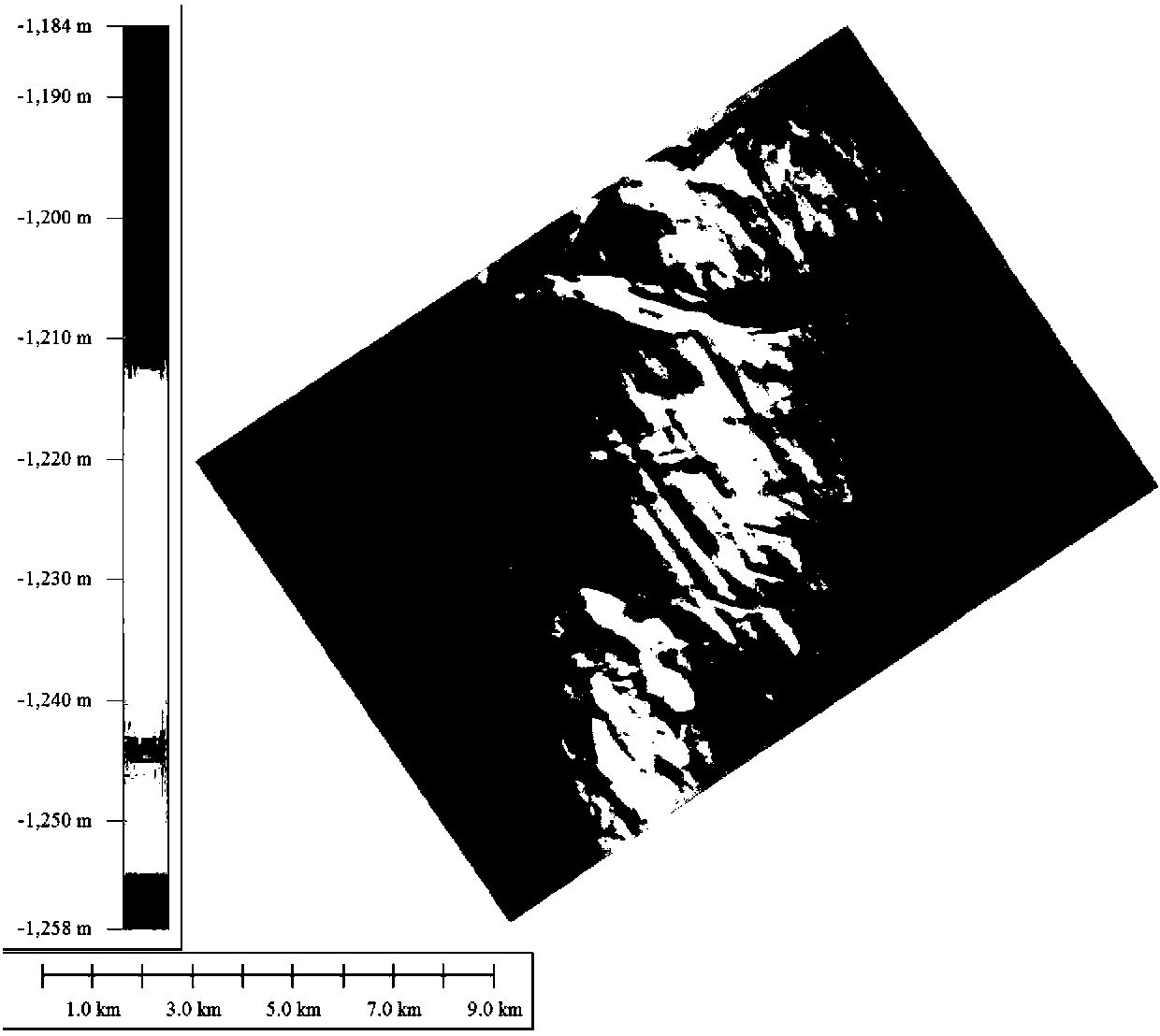
[0031] The invention uses the Otsu algorithm to estimate the threshold value of the target area segmentation by analyzing and processing the distribution of the water depth change rate of the geomorphic unit, and realizes the boundary extraction of the deep sea / deep water channel geomorphic unit. In this embodiment, the water depth data is measured by 3D seismic exploration technology. In the target area of ​​this embodiment, complex geomorphic boundaries are distributed. The data volume of the target area is 53.6M, contains 1,125503 measurement points, and the area is 3.42×10 2 Square kilometers, the water depth range is 1184-1258 meters.

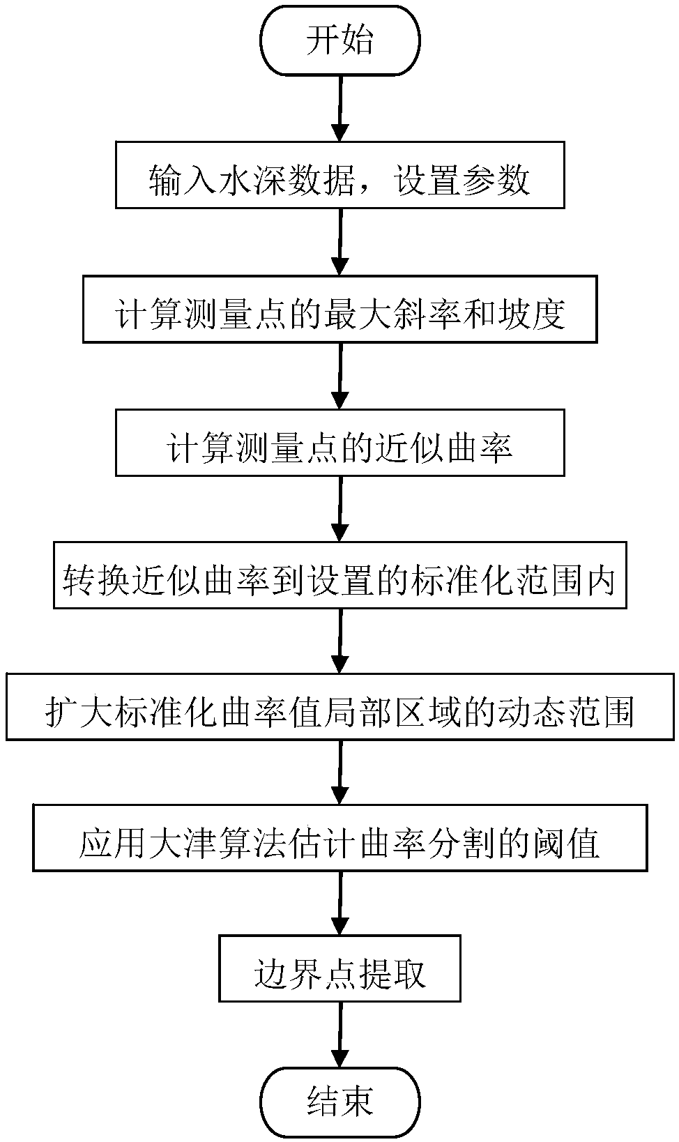
[0032] figure 1 It is the water depth map of the target area. figure 2 Flow chart for the extraction of boundary points of the geomorphic unit.

[0033] The specific implementation steps of the present invention are as follows:

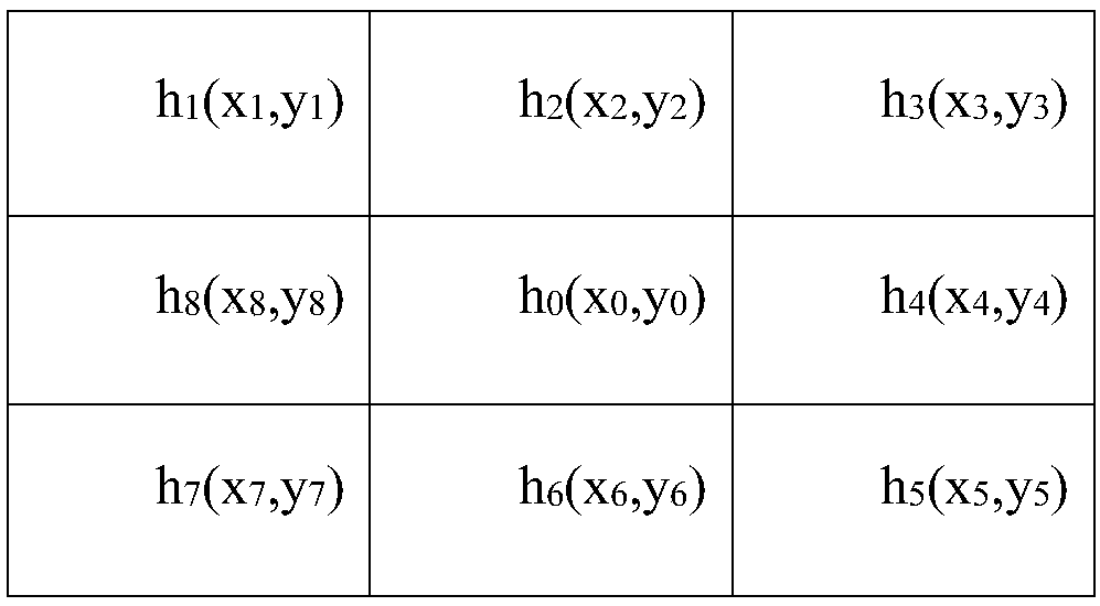
[0034] (1) Calculate the slope distribution of the target area

[0035] according to And θ(x o , Y o )=tan -1 k(x o...


PUM


Abstract

The invention discloses a seabed geomorphologic boundary extraction method based on an OTSU algorithm. The method comprises the following steps: 1) calculating maximum slope and gradient of each measurement point according to water depth distribution in a target area; 2) calculating similar curvature of each measurement point according to gradient distribution in the target area; 3) normalizing the similar curvature value of each measurement point in the target area to a specified range; 4) according to the nonlinear transformation relation, expanding the dynamic range of a local area of the normalized curvature value; 5) estimating threshold of curvature segmentation through the OTSU algorithm; and 6) dividing the measurement points, the curvature values of which are not smaller than thethreshold, into boundary points. The geomorphologic boundary extraction method can effectively identify complex geomorphologic boundary details, suppresses course noise, greatly reduces work intensityof scientific research and engineering personnel and improves work efficiency thereof; and the method is suitable for boundary extraction of geomorphologic units in relevant fields of morphological analysis, marine surveying and mapping, seabed resource survey and oceanographic engineering.

Description

Technical field [0001] The invention relates to the technical fields of marine surveying and mapping, marine engineering, marine oil and gas resources and the like, and in particular relates to a method for extracting seabed landform boundaries based on Dajin algorithm. Background technique [0002] Undersea topography usually refers to the shape of the solid earth's surface covered by sea water. The seabed, like the land, is distributed with complex and diverse landforms. The seabed topography and landform are closely related to the exploration and exploitation of marine resources. The distribution of submarine topography is an important reference for the construction of drilling platforms and the laying of submarine pipelines. The acquisition and research of seabed geomorphic features are becoming more and more important. Obtaining seabed topography maps has become a hot topic for experts and scholars. [0003] Water depth distribution data is one of the main data for geomorp...

Claims


Application Information

Patent Timeline
IPC IPC(8): G06T7/12G06T7/13G06T7/194
CPCG06T2207/30184G06T7/12G06T7/13G06T7/194
Inventor 吴时国王大伟谢杨冰
Owner INST OF DEEP SEA SCI & ENG CHINESE ACADEMY OF SCI
Why Eureka
Try Eureka