Automobile navigation system height information identification detection method

A technology of altitude information and car navigation, applied in the field of vehicle satellite navigation system, can solve the problems of navigation driving route error, car navigation system misjudgment, navigation route planning error, etc., to achieve the effect of low development cost, simple and accurate navigation

Inactive Publication Date: 2018-08-17
张天骏
View PDF4 Cites 2 Cited by
  • Summary
  • Abstract
  • Description
  • Claims
  • Application Information

AI Technical Summary

Problems solved by technology

[0003] Existing vehicle location detection technology is mainly based on vehicle GPS to locate and obtain vehicle location information, but the disadvantage is that the obtained vehicle location information has a large deviation in height positioning, and it is impossible to identify whether the vehicle is on the viaduct, making navigation Route planning error, unable to navigate accurately
The reason is: when the car is driving on two intersecting viaducts, or driving on the road below the viaduct, because the height difference between the intersecting viaducts or the viaduct and the road below is ≥ 3m, the car navigation system cannot recognize it at this time. If the car is driving on the viaduct, or cannot identify whether it is driving on the viaduct or the road below the viaduct, this will cause misjudgment by the car navigation system, resulting in errors in the given navigation route and inaccurate navigation

Method used


Image

  • Automobile navigation system height information identification detection method
  • Automobile navigation system height information identification detection method

Examples


Embodiment Construction

[0020] The embodiments of the present invention will be described in detail below in conjunction with the accompanying drawings. This embodiment is implemented on the premise of the technical solution of the present invention, and detailed implementation methods and specific operating procedures are provided, but the scope of protection of the present invention is not limited to the following Described embodiment.

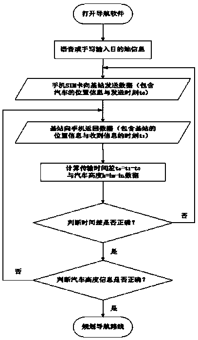
[0021] Such as figure 1 , 2 As shown, the car navigation system altitude information detection method of the present invention comprises the following steps:

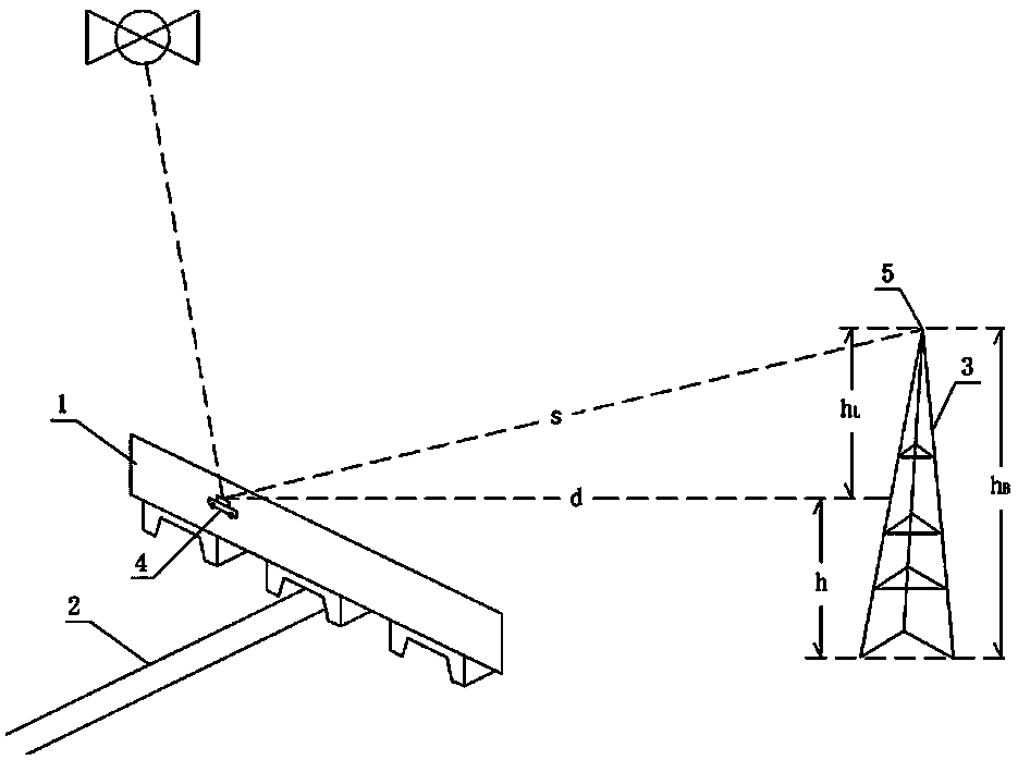
[0022] The first step is to obtain the contour map data through the National Geographic Management Department, the municipal planning management department to obtain the position and height information data of each viaduct 1 and 2 in each city, and each mobile signal operator to obtain the data of each mobile communication base station 3 Location and altitude information data, and store the above data in t...


PUM


Abstract

The invention discloses an automobile navigation system height information identification detection method which includes the steps: firstly, acquiring contour map data, viaduct position and height information data and mobile communication base station position and height information data, and storing the acquired data into a mobile phone database; secondly, transmitting current position coordinates and transmitting moment data to a mobile communication base station after the current position coordinates of an automobile are acquired by a mobile phone satellite navigation system through a GPS(global position system); thirdly, returning horizontal position coordinates and height coordinates of the mobile communication base station and returning moment to a mobile phone when the position coordinates and the transmitting moment data are received by the mobile communication base station; fourthly, calculating height of a mobile communication base station signal receiving point and horizontal distance between the automobile and the mobile communication base station signal receiving point by a mobile phone data processing unit; fifthly, comparing mobile phone processor time data and a preset threshold value, judging whether the mobile phone processor time data are right or not, repeating the second step to the fourth step if not, and rightly planning route navigation. The method hasthe advantages of rapidness and accuracy in navigation.

Description

technical field [0001] The invention relates to a vehicle-mounted satellite navigation system, in particular to a method for identifying and detecting height information of a vehicle navigation system. Background technique [0002] At present, the car navigation system generally includes the following modules: car position detection module, path planning module, error compensation module and intelligent voice reminder module. The car position detection module is the basic module of the car navigation system. During the driving process of the car, whether the accurate navigation of the driving route can be realized directly affects whether the car can reach the destination accurately. [0003] Existing vehicle location detection technology is mainly based on vehicle GPS to locate and obtain vehicle location information, but the disadvantage is that the obtained vehicle location information has a large deviation in height positioning, and it is impossible to identify whether t...

Claims


Application Information

Patent Timeline
Patent Type & Authority Applications(China)
IPC IPC(8): G01C5/00G01C21/34G01S19/42
CPCG01C5/00G01C21/34G01S19/42
Inventor 张天骏
Owner 张天骏
Why Eureka
Try Eureka