Underground pipeline positioning method based on CORS (continuous operational reference system)

A technology of underground pipelines and positioning methods, which is applied to radio wave measurement systems, satellite radio beacon positioning systems, maps/plans/charts, etc., and can solve problems such as inconvenient positioning operations and poor positioning effects.

Inactive Publication Date: 2012-06-20
XIAN MEIHANG INFORMATION IND
View PDF5 Cites 41 Cited by
  • Summary
  • Abstract
  • Description
  • Claims
  • Application Information

AI Technical Summary

Problems solved by technology

[0007] The technical problem to be solved by the present invention is to provide an underground pipeline positioning method based on the CORS system in view of the deficiencies in the above-m

Method used


Image

  • Underground pipeline positioning method based on CORS (continuous operational reference system)
  • Underground pipeline positioning method based on CORS (continuous operational reference system)
  • Underground pipeline positioning method based on CORS (continuous operational reference system)

Examples


Embodiment Construction

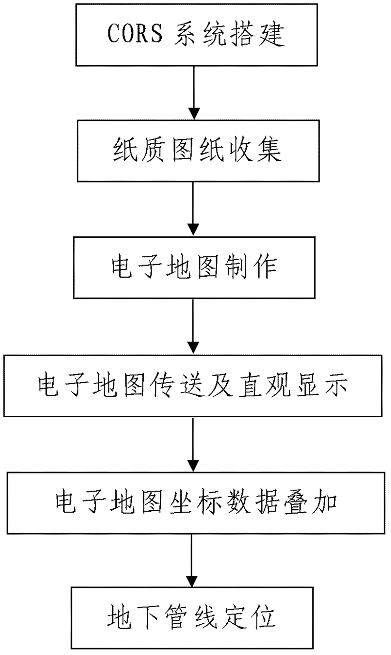
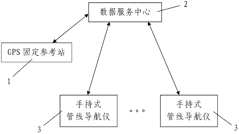
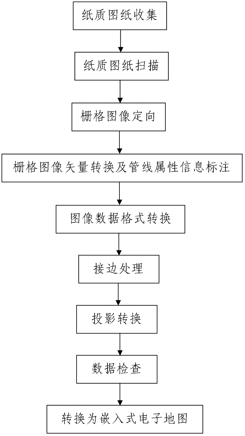
[0057] Such as figure 1 , figure 2 and image 3 As shown, the underground pipeline positioning method based on the CORS system of the present invention includes the following steps:

[0058] Step 1: CORS system establishment: Deploy one or more GPS fixed reference stations 1 in the area to be located where underground pipeline positioning is required. The GPS fixed reference station 1 is a GPS receiving system with a fixed position. The GPS fixed reference station 1 and the data service center 2 carry out two-way communication through the data transmission system, and the data service center 2 and the mobile data processing terminal held by pipeline positioning staff carry out two-way communication through the positioning and navigation data broadcasting system. In communication, the number of the mobile data processing terminal is one or more and it includes a data processor and a parameter input unit and a display unit respectively connected to the data processor; the GPS fixe...


PUM

PropertyMeasurementUnit
Depthaaaaaaaaaa

Abstract

The invention discloses an underground pipeline positioning method based on a CORS (continuous operational reference system). The method comprises the following steps of: I, establishing a CORS; II, collecting paper drawings: collecting the pipeline as-built drawings of all underground pipelines paved in an area to be positioned and the topographical map around each underground pipeline respectively; III, making an electronic map, wherein the making process comprises the steps of paper map electronization treatment, drawing scanning and pretreatment, raster image transfer, raster image orientation, image sector conversion, pipeline attribution information marking, edge matching treatment, projection conversion, data check, conversion into an embedded electronic map and the like; IV, transferring and visually displaying the electronic map; V, superposing the coordinate data of the electronic map; and VI, positioning the underground pipelines. The method disclosed by the invention is easy and convenient to use and operate, has a good using effect and high practical value, and can really realize accurate positioning of the underground pipelines and effectively solve the problems of inconvenience in positioning operation, relatively bad positioning effect and the like of the existing underground pipeline positioning method.

Description

Technical field [0001] The invention belongs to the technical field of electronic geographic information processing, and particularly relates to an underground pipeline positioning method based on a CORS system. Background technique [0002] With the rapid progress and popularization of GPS technology, its role in urban surveying has become more and more important. At present, the continuous operation satellite positioning service integrated system (Continuous Operational Reference System, abbreviated as CORS) established by the multi-base station network RTK ((Real-time kinematic) technology) has become one of the development hotspots of urban GPS applications. The CORS system is satellite positioning. Technology, computer network technology, digital communication technology and other high-tech multi-directional and deeply crystalline products. The CORS system is composed of five parts: reference station network, data processing center, data transmission system, positioning and ...

Claims


Application Information

Patent Timeline
IPC IPC(8): G09B29/00G09B29/10G01S19/42
Inventor 孙作勇张培宏张继忠雷国锋
Owner XIAN MEIHANG INFORMATION IND
Why Eureka
Try Eureka