Method and system for profit division according to regions, and terminal
A regional and profitable technology, applied in the computer field, can solve the problem that offline channel dealers have no motivation to promote the brand and reduce the profit and income of offline channel dealers, so as to improve the motivation of promoting the brand and increase the profit and income.
- Summary
- Abstract
- Description
- Claims
- Application Information
AI Technical Summary
Problems solved by technology
Method used
Image
Examples
Embodiment 1
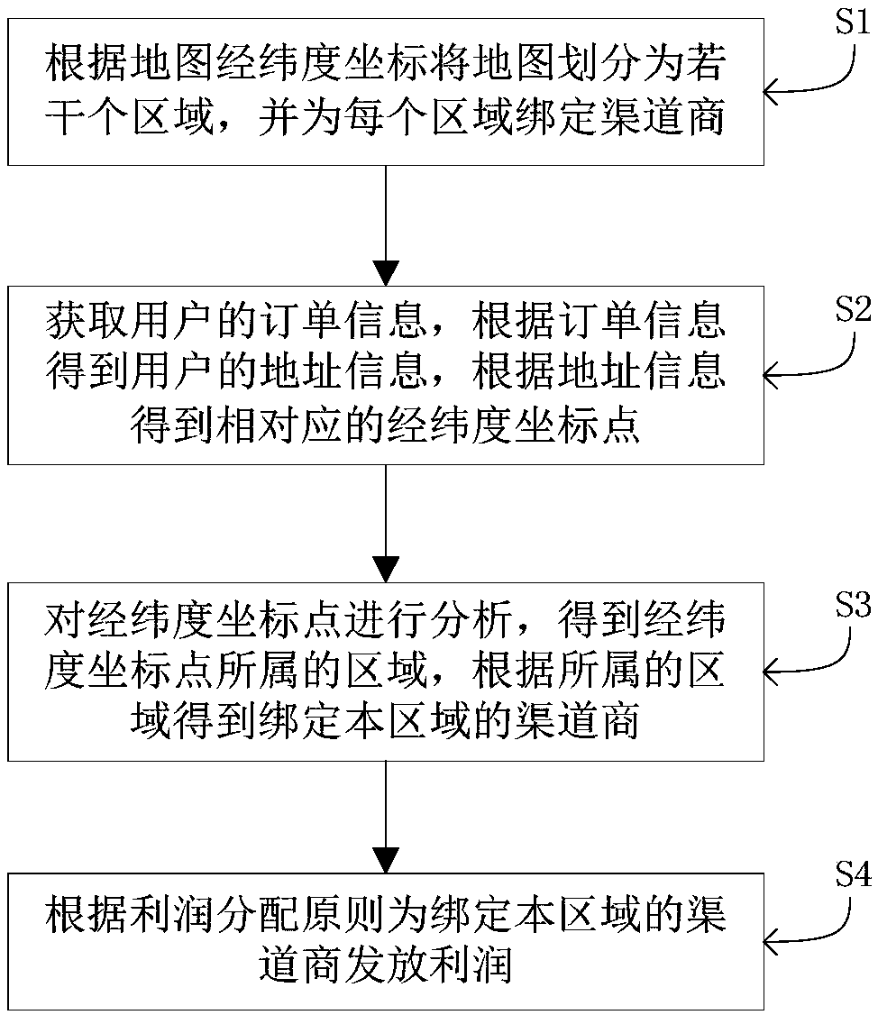
[0037] This embodiment provides a method of dividing profits by region, such as figure 1 shown, including the following steps:
[0038] S1. Divide the map into several regions according to the latitude and longitude coordinates of the map, and bind channel providers to each region. In this embodiment, the map latitude and longitude coordinates include self-established map latitude and longitude coordinates or map latitude and longitude coordinates provided by a third party. One region can be bound to one or more channel providers, and the channel providers bound to multiple regions can be the same channel provider (that is, the same channel provider can be bound to multiple regions at the same time). The channel dealers include directly-operated stores or / and franchise stores or / and agents or / and natural person shopping guides.
[0039] For example, the map of China is divided into 34 provincial-level administrative regions according to the boundaries of each provincial-leve...
Embodiment 2
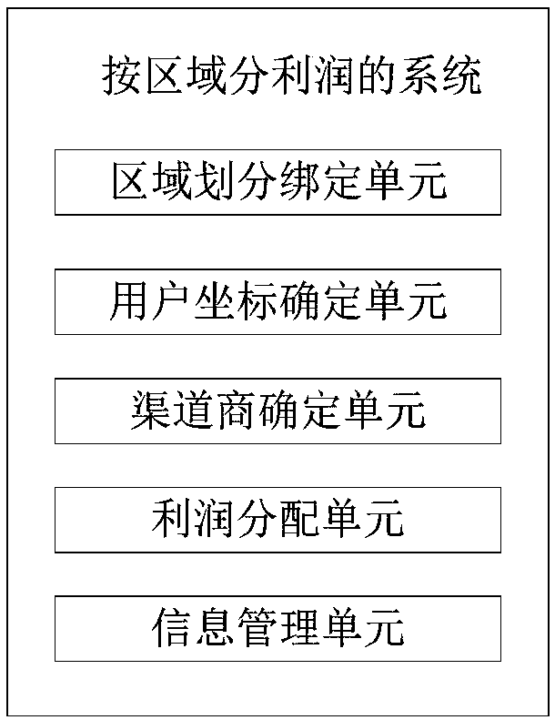
[0046] This embodiment provides a system for distributing profits by region, which is applicable to the method for distributing profits by region described in Embodiment 1, such as figure 2 As shown, the system includes an area division binding unit, a user coordinate determination unit, a channel provider determination unit, a profit distribution unit, an information management unit, and the like.
[0047]The area division binding unit is used to divide the map into several areas according to the latitude and longitude coordinates of the map, and bind channel providers for each area. In this embodiment, the map latitude and longitude coordinates include self-established map latitude and longitude coordinates or map latitude and longitude coordinates provided by a third party. One of the regions can be bound with one or more distributors, and the distributors include directly-operated stores or / and franchise stores or / and agents or / and natural person shopping guides.
[0048...
Embodiment 3
[0059] This embodiment provides a terminal, including a processor and a memory, the memory is used to store a computer program, the computer program includes program instructions, the processor is configured to invoke the program instructions, and execute the program as described in the embodiment A described method:
[0060] S1, divide the map into several regions according to the latitude and longitude coordinates of the map, and bind channel providers to each region;
[0061] S2, obtain the user's order information, obtain the user's address information according to the order information, and obtain the corresponding longitude and latitude coordinate points according to the address information;
[0062] S3, analyzing the latitude and longitude coordinate points to obtain the region to which the latitude and longitude coordinate point belongs, and obtain the channel provider bound to the region according to the region to which it belongs;
[0063] S4, according to the princ...
PUM
 Abstract
Description
Claims
Application Information
 - R&D
- Intellectual Property
- Life Sciences
- Materials
- Tech Scout
- Unparalleled Data Quality
- Higher Quality Content
- 60% Fewer Hallucinations
Browse by: Latest US Patents, China's latest patents, Technical Efficacy Thesaurus, Application Domain, Technology Topic, Popular Technical Reports.
© 2025 PatSnap. All rights reserved.Legal|Privacy policy|Modern Slavery Act Transparency Statement|Sitemap|About US| Contact US: help@patsnap.com


