Map data fusion method, device, electronic equipment and storage medium

A technology of map data and fusion method, applied in the computer field, can solve problems such as inaccurate fusion results, achieve the effect of reducing errors and improving accuracy

Active Publication Date: 2019-09-06
BEIJING SANKUAI ONLINE TECH CO LTD
View PDF6 Cites 0 Cited by
  • Summary
  • Abstract
  • Description
  • Claims
  • Application Information

AI Technical Summary

Problems solved by technology

[0004] The present application provides a map data fusion method to solve the problem of inaccurate fusion results existing in the map data fusion method in the prior art

Method used


Image

  • Map data fusion method, device, electronic equipment and storage medium
  • Map data fusion method, device, electronic equipment and storage medium
  • Map data fusion method, device, electronic equipment and storage medium

Examples


Embodiment 1

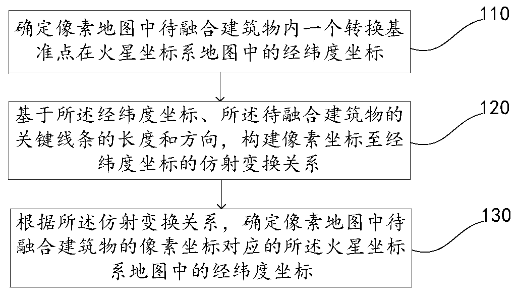
[0048] A map data fusion method disclosed in this embodiment, such as figure 1 As shown, the method includes: Step 110 to Step 130.

[0049] Step 110, determine the longitude and latitude coordinates of a transformation reference point in the Mars coordinate system map in the pixel map to be fused.

[0050] First, mark the position of a conversion datum point in the building to be fused in the Mars coordinate system map. During specific implementation, a vertex of the ground projection of the building to be fused can be selected as the conversion reference point, such as selecting the position of the upper left corner of the ground projection in the building to be fused as the conversion reference point, or, selecting the ground projection of the building to be fused The position of the lower right corner of is used as the conversion datum point. Then, read the latitude and longitude coordinates of the point through the interface of the Mars coordinate system map; or manuall...

Embodiment 2

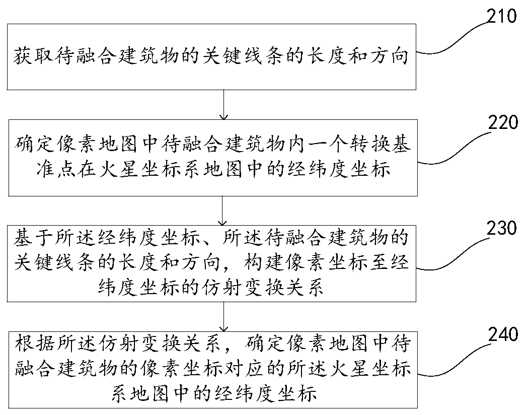
[0059] A map data fusion method disclosed in this embodiment, such as figure 2 As shown, the method includes: Step 210 to Step 240.

[0060] Step 210, acquiring the length and direction of the key lines of the building to be fused.

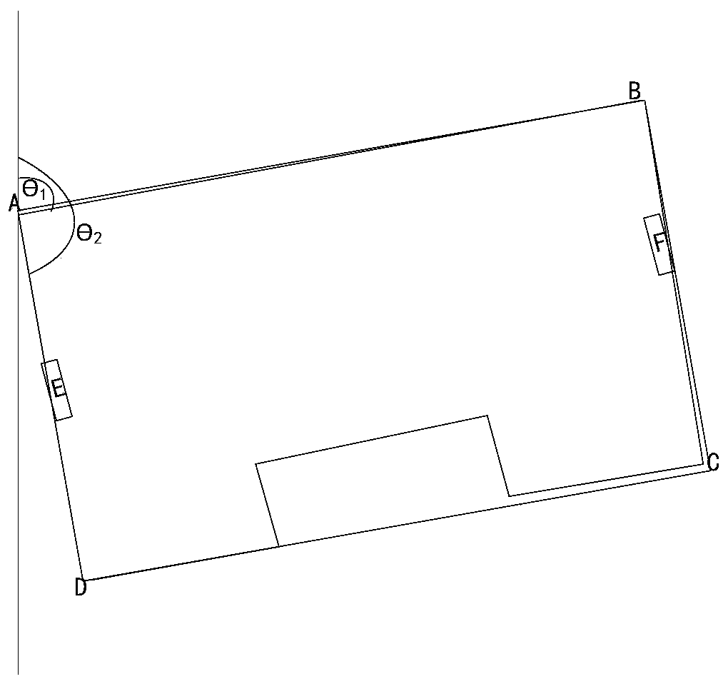
[0061] In the embodiment of the present invention, the length of the key line of the building to be fused refers to the actual size of the building. During specific implementation, before constructing the affine transformation relationship, the length of the key line of the building to be fused can be measured by a laser rangefinder; or, the building to be fused can be obtained through the pixel map information of the building to be fused The length of the key line of the object. For example, using a laser range finder to measure the distance between two striking signs that are far away in the building to be fused, as image 3 The distance between door E and door F in . Or measure the size of the design drawing of the building to be fused by ...

Embodiment 3

[0082] A map data fusion device disclosed in this embodiment, such as Figure 4 As shown, the device includes:

[0083] Conversion reference point coordinate mapping module 410, used to determine the longitude and latitude coordinates of a conversion reference point in the Mars coordinate system map in the building to be fused in the pixel map;

[0084] Transformation relationship determination module 420, configured to construct an affine transformation relationship from pixel coordinates to longitude-latitude coordinates based on the latitude-longitude coordinates, the length and direction of the key lines of the building to be fused;

[0085] The map data fusion module 430 is configured to determine the latitude and longitude coordinates in the Mars coordinate system map corresponding to the pixel coordinates of the building to be fused in the pixel map according to the affine transformation relationship.

[0086] During specific implementation, in order to reduce computat...


PUM


Abstract

The map data fusion method disclosed in the embodiment of the present application belongs to the field of computer technology, and solves the problem of inaccurate fusion results existing in the map data fusion method in the prior art. The method includes: determining the latitude and longitude coordinates of a conversion reference point in the Martian coordinate system map in the pixel map to be fused; based on the latitude and longitude coordinates, the length and direction of the key lines of the building to be fused, constructing a pixel An affine transformation relationship from coordinates to latitude and longitude coordinates; according to the affine transformation relationship, determine the latitude and longitude coordinates in the Mars coordinate system map corresponding to the pixel coordinates of the building to be fused in the pixel map. Through the map data fusion method disclosed in the embodiment of the present application, it is only necessary to manually select a conversion reference point, which can complete the fusion of pixel map data to Mars coordinate system map data, reduce the error caused by manual selection of reference points, and improve the map. Accuracy of data fusion.

Description

technical field [0001] The present application relates to the field of computer technology, in particular to a map data fusion method, device, electronic equipment and storage medium. Background technique [0002] The Mars coordinate system is a GPS coordinate system standard commonly used in the industry. It is a coordinate system for modeling world positions. The Mars coordinate system adds some irregular offsets, rotations or scaling to the real map coordinate system. Due to the requirements of national information security, the parameters of these transformations such as offset, rotation or scaling are not disclosed to the public. Tourist maps and navigation maps in the prior art are all established based on the Martian coordinate system. In the prior art, outdoor locations are coordinates in the Mars coordinate system represented by latitude and longitude, while indoor locations, such as indoor environmental locations such as shopping malls and office buildings, are us...

Claims


Application Information

Patent Timeline
Patent Type & Authority Patents(China)
IPC IPC(8): G06K9/62G06F16/29
CPCG06F18/25
Inventor 高艳涛
Owner BEIJING SANKUAI ONLINE TECH CO LTD
Why Eureka
Try Eureka