Full convolution network based remote-sensing image land cover classifying method

A fully convolutional network and remote sensing image technology, applied in the field of remote sensing image surface coverage classification, can solve problems such as low computing efficiency and large storage overhead, and achieve the effect of improving performance, strong practicability, and broad application prospects.

Inactive Publication Date: 2018-09-14
FUZHOU UNIV
View PDF3 Cites 29 Cited by
  • Summary
  • Abstract
  • Description
  • Claims
  • Application Information

AI Technical Summary

Problems solved by technology

[0003] At present, there are few related studies on the land cover classification of remote sensing images at the pixel level. Traditional machine learning-based classification methods, in order to classify a pixel, need to use an image block around the pixel as input for training and It is predicted that adjacent pixel blocks are b

Method used


Image

  • Full convolution network based remote-sensing image land cover classifying method
  • Full convolution network based remote-sensing image land cover classifying method
  • Full convolution network based remote-sensing image land cover classifying method

Examples


Embodiment Construction

[0033] The present invention will be further described in detail below in conjunction with the accompanying drawings and specific embodiments.

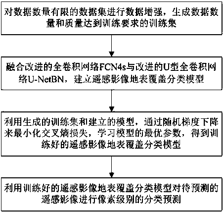
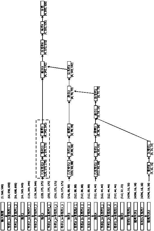
[0034] The present invention provides a remote sensing image land cover classification method based on a fully convolutional network, such as figure 1 shown, including the following steps:

[0035] Step S1: Carry out data enhancement on the data set with a limited amount of data, and generate a training set whose data amount and quality meet the training requirements.

[0036] The remote sensing image data set used for training is generally obtained by visual interpretation and manual drawing, which requires a lot of manpower, so it is necessary to use a certain data enhancement method for enhancement. First, the remote sensing images in the data set are stretched and scaled at different scales to increase the diversity of the data; then, the remote sensing images of a single large image in the data set are divided into blocks of the...


PUM


Abstract

The invention relates to a full convolution network based remote-sensing image land cover classifying method. The method comprises the following steps: S1, performing data enhancement on a data set with limited data quantity; and generating a training set of which the data quantity and quality meet the training requirement; S2, combining the improved full convolution network FCN4s and the improvedU type full convolution network U-NetBN; and building a remote-sensing image land cover classifying model; S4, minimizing the cross entropy loss as the decrease of random gradient; learning the optimal parameters of the model to obtain the trained remote-sensing image land cover classifying model; and S4, performing pixel class classifying prediction on the predicted remote-sensing image throughthe trained remote image land cover classifying model. According to the method, the properties of the FCN full convolution network and the U-Net full convolution network are combined, so that the remote-sensing image land cover classifying performance can be improved.

Description

technical field [0001] The invention relates to the fields of image processing and computer vision, in particular to a method for classifying land cover of remote sensing images based on a fully convolutional network. Background technique [0002] With the continuous improvement of the resolution of satellite remote sensing images and aerial remote sensing images, people can obtain more useful data and information from remote sensing images. Land cover classification of remote sensing images is an important content in the field of remote sensing research. It has strong application value in various fields such as land, national defense, surveying and mapping, agriculture, cities, and disaster prevention and reduction. Therefore, it is very important to improve the accuracy of land cover classification of remote sensing images. Significance. The first surface classification method of remote sensing images is the image visual interpretation technology, that is, the image is ma...

Claims


Application Information

Patent Timeline
IPC IPC(8): G06K9/00G06K9/62G06N3/04G06N3/08
CPCG06N3/082G06V20/13G06N3/045G06F18/25G06F18/24
Inventor 牛玉贞陈培坤郭文忠
Owner FUZHOU UNIV
Why Eureka
Try Eureka