Method for laser radar navigation of four-rotor aircraft in continuous multilateral geometric environment

A quadrotor aircraft, lidar technology, applied in the direction of navigation, navigation, mapping and navigation through speed/acceleration measurement

Active Publication Date: 2018-09-21
NANJING UNIV OF AERONAUTICS & ASTRONAUTICS
View PDF16 Cites 4 Cited by
  • Summary
  • Abstract
  • Description
  • Claims
  • Application Information

AI Technical Summary

Problems solved by technology

[0004] Purpose of the invention: the purpose of the present invention is to provide a four-rotor aircraft laser radar navigation method in a continuous polygonal geometric environment, to solve the problem of stable flight of the quadrotor aircraft in a polygonal geometric environment

Method used


Image

  • Method for laser radar navigation of four-rotor aircraft in continuous multilateral geometric environment
  • Method for laser radar navigation of four-rotor aircraft in continuous multilateral geometric environment
  • Method for laser radar navigation of four-rotor aircraft in continuous multilateral geometric environment

Examples


Embodiment Construction

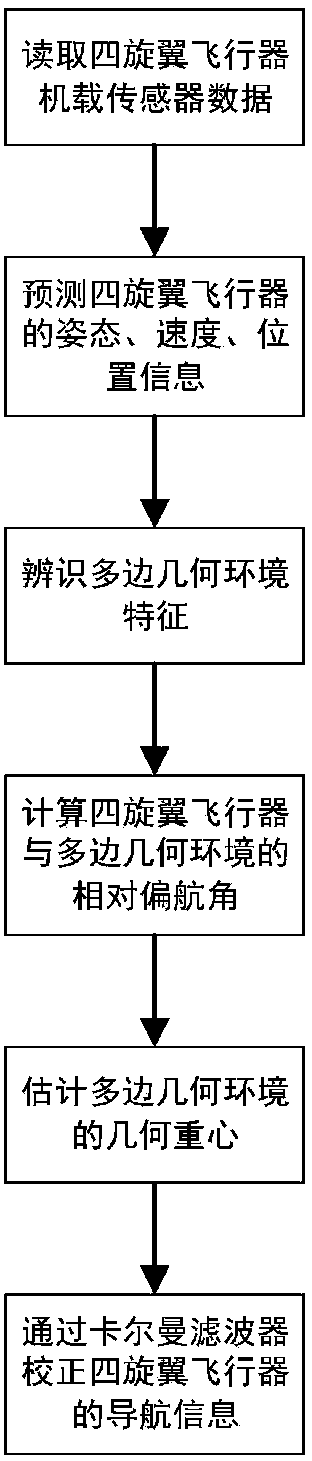
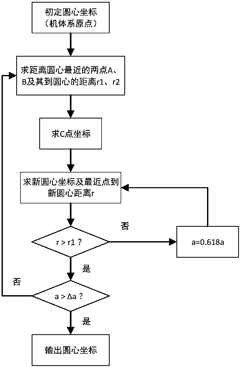
[0113] like figure 1 Shown, the concrete steps of the present invention are as follows:

[0114] Step (1): Periodically read the sensor information of the quadrotor aircraft at time k, including lidar information S(k), gyroscope information accelerometer information Barometric altimeter information h b (k);

[0115] Step (2): Predict the attitude, speed, and position of the quadrotor aircraft at time k through the inertial sensor, the specific method is as follows:

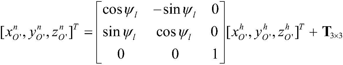
[0116] (2.1) The attitude quaternion prediction adopts the following formula:

[0117]

[0118] Among them, Q(k)=[q o (k)q 1 (k)q 2 (k)q 3 (k)] T Be the posture quaternion of k moment, superscript T represents the transposition of matrix;; Q(k-1)=[q o (k-1)q 1 (k-1)q 2 (k-1)q 3 (k-1)] T is the attitude quaternion at k-1 moment; ΔT is the discrete sampling period; Calculated by the following formula:

[0119]

[0120] in Calculated by the following formula:

[0121]

[0122] in, is ...


PUM


Abstract

The invention discloses a method for laser radar navigation of a four-rotor aircraft in a continuous multilateral geometric environment, belonging to the fields of autonomous navigation and guidance.The method can be used for the navigation of the four-rotor aircraft in the multilateral geometric environment; a laser radar installed on the four-rotor aircraft is combined with an inertial sensor,so that navigation information is generated, and the multi-rotor aircraft is enabled to fly in the center of gravity of the multilateral geometric environment. According to the method, the multilateral geometric environment is identified by means of the laser radar, so that the relative distances and orientations between the four-rotor aircraft and all the sides of the environment can be estimated. The information estimated by the laser radar and the inertial sensor are subjected to data fusion by means of a filter, so that the position, velocity and attitude information of the four-rotor aircraft can be obtained. Then, the center of gravity of the geometric environment is calculated by means of data measured by the laser radar, so that the four-rotor aircraft is enabled to fly at the geometric center of gravity. The method enables the four-rotor aircraft to fly safely and stably in the multilateral geometric environment.

Description

technical field [0001] The invention relates to the field of autonomous navigation and technology, in particular to a four-rotor aircraft lidar navigation method in a continuous polygonal geometric environment. Background technique [0002] With the development of related technologies of quadrotor aircraft, it is applied to more and more flight missions, which puts forward higher and higher requirements for navigation performance. Lidar is one of the commonly used navigation equipment for quadrotor aircraft. It is not interfered by radio signals and light, and has strong autonomy and high navigation accuracy. When lidar is used for navigation, Simultaneous Localization And Mapping (SLAM for short) is commonly used, and various sensor data are collected and calculated on the carrier to realize its own position, attitude positioning and Construction of the scene map. [0003] A polygonal geometric environment refers to an environment with regular polygons around it, such as ...

Claims


Application Information

Patent Timeline
Patent Type & Authority Applications(China)
IPC IPC(8): G01C21/16G01C21/20G01S17/93G05D1/10
CPCG01C21/165G01C21/20G01S17/933G05D1/101
Inventor 邹冰倩吕品赖际舟石鹏付相可
Owner NANJING UNIV OF AERONAUTICS & ASTRONAUTICS
Why Eureka
Try Eureka