Crop drought loss assessment system based on remote sensing data and crop drought loss assessment method based on remote sensing data

A remote sensing data and evaluation system technology, applied in data processing applications, instruments, resources, etc., can solve the problems of change evaluation, inaccuracy, drought-affected area and wide range of losses, etc., and achieve the effect of real-time monitoring and evaluation

Inactive Publication Date: 2018-10-02
INST OF REMOTE SENSING & DIGITAL EARTH CHINESE ACADEMY OF SCI
View PDF3 Cites 3 Cited by
  • Summary
  • Abstract
  • Description
  • Claims
  • Application Information

AI Technical Summary

Problems solved by technology

[0007] In view of the above-mentioned problems, the present invention is proposed in order to provide a remote sensing data-based crop drought loss assessment system and method that overcomes the above-mentioned problems or at least partially solves the above-mentioned problems. Automatically determine the drought situation of crops based on remote sensing data to solve the problem of inaccurate assessment due to the wide range of drought area and loss, and the variation of drought degree on time scale

Method used


Image

  • Crop drought loss assessment system based on remote sensing data and crop drought loss assessment method based on remote sensing data
  • Crop drought loss assessment system based on remote sensing data and crop drought loss assessment method based on remote sensing data
  • Crop drought loss assessment system based on remote sensing data and crop drought loss assessment method based on remote sensing data

Examples


Embodiment Construction

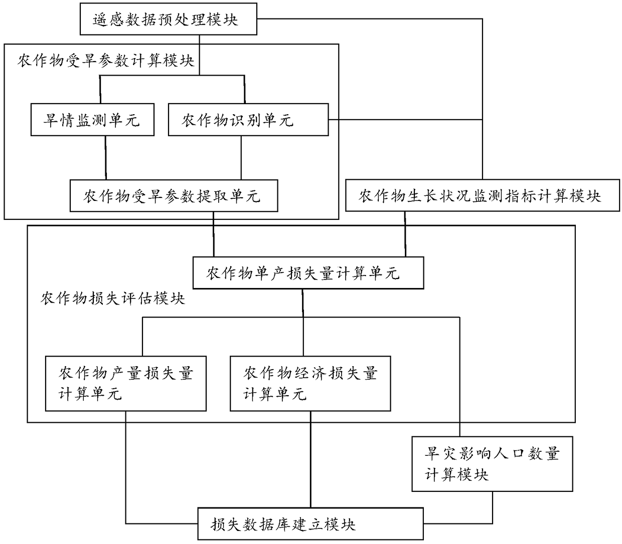
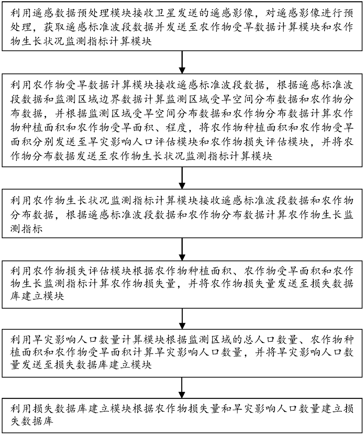
[0047] Exemplary embodiments of the present disclosure will be described in more detail below with reference to the accompanying drawings. Although exemplary embodiments of the present disclosure are shown in the drawings, it should be understood that the present disclosure may be embodied in various forms and should not be limited by the embodiments set forth herein. Rather, these embodiments are provided for more thorough understanding of the present disclosure and to fully convey the scope of the present disclosure to those skilled in the art.

[0048] Those skilled in the art can understand that, unless otherwise defined, all terms (including technical terms and scientific terms) used herein have the same meaning as commonly understood by those of ordinary skill in the art to which this invention belongs. It should also be understood that terms, such as those defined in commonly used dictionaries, should be understood to have meanings consistent with the meanings in the co...


PUM


Abstract

The invention provides a crop drought loss assessment system based on remote sensing data and a crop drought loss assessment method based on the remote sensing data. The system comprises a crop drought data calculation module which is used for calculating the crop distribution data, the crop planting area and the crop drought area; a crop growth condition monitoring indicator calculation module which is used for calculating the crop growth condition monitoring indicators based on the crop distribution data; a crop loss assessment module which is used for calculating the crop loss according tothe crop planting area, the crop drought area and the crop growth condition monitoring indicators; a drought affected population calculation module which is used for calculating the drought affected population according to the total population of the monitoring region, the crop planting area and the crop drought area; and a loss database establishing module which is used for establishing a loss database according to the crop loss and the drought affected population. According to the system and the method, the degree of the drought loss can be accurately and comprehensively mastered in real time.

Description

technical field [0001] The invention relates to the technical field of crop disaster loss assessment, in particular to a crop drought loss assessment system and method based on remote sensing data. Background technique [0002] Since the traditional drought monitoring and evaluation rely more on the precipitation of ground observation points, the soil moisture content of agricultural gas stations and other data to diagnose the occurrence of drought, the number and layout of the stations are insufficient in terms of data representation and timeliness, and the station Consistency in measurement methods poses certain difficulties in the use of data. Therefore, it is difficult to grasp the changes and losses of droughts in real time, accurately and comprehensively. [0003] The mesophyll tissue in the active leaves of vegetation has a higher reflectance in the near-infrared band, while chlorophyll has a stronger absorption in the red-light band, which makes the reflectance of t...

Claims


Application Information

Patent Timeline
Patent Type & Authority Applications(China)
IPC IPC(8): G06Q10/06G06Q50/02
CPCG06Q10/0639G06Q50/02
Inventor 常胜吴炳方闫娜娜
Owner INST OF REMOTE SENSING & DIGITAL EARTH CHINESE ACADEMY OF SCI
Why Eureka
Try Eureka