Method for monitoring surface subsidence of areas along urban subways

A technology for surface subsidence and subways, applied in radio wave reflection/re-radiation, measurement devices, surveying and navigation, etc., can solve problems such as inability to accurately capture dynamic evolution process, missing, monitoring area coverage monitoring results, etc.

Inactive Publication Date: 2018-10-16
伟志股份公司
View PDF4 Cites 39 Cited by
  • Summary
  • Abstract
  • Description
  • Claims
  • Application Information

AI Technical Summary

Problems solved by technology

[0005] In order to solve the problems of loss of correlation and atmospheric delay when D-InSAR technology is applied to the monitoring of surface deformation along urban subway lines, and the inability of data sources to fully cover the monitoring area in time and space, resulting in missing monitoring results and the inability to accurately capture the dynamic evolution process, etc., The purpose of the present invention is to provide a method for monitoring surface subsidence along urban subway lines, which can greatly improve the InSAR refined monitoring level of surface deformation along subway lines

Method used


Image

  • Method for monitoring surface subsidence of areas along urban subways
  • Method for monitoring surface subsidence of areas along urban subways
  • Method for monitoring surface subsidence of areas along urban subways

Examples


Embodiment

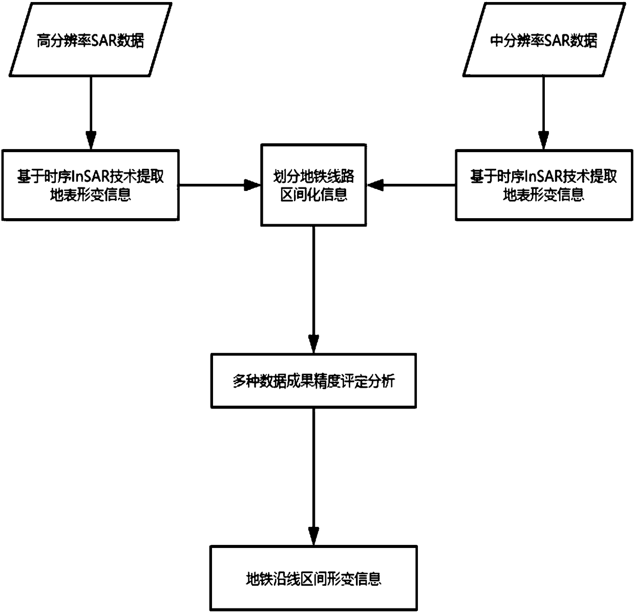
[0071] Example: such as figure 1 As shown, a method for monitoring land surface subsidence along an urban subway line includes the following steps:

[0072] S1. Select data from at least two different data sources, and perform continuous and dense coverage in time and space within the scope of influence of the monitoring interval along the subway;

[0073] S2. Using time-series SBAS-InSAR technology and PS-InSAR technology to jointly interferentially process the data source data selected in step S1, obtain the optimal result of monitoring urban area surface deformation;

[0074] S3. Carry out accuracy assessment and fusion analysis on the optimal results obtained in step S2, and obtain detailed deformation information and evolution rules along the subway line.

[0075] In this embodiment, in step S1, the high and medium resolution SAR data are selected, specifically as follows: at least one high resolution SAR data and at least one medium resolution SAR data are selected, and...


PUM


Abstract

The invention relates to a method for monitoring surface subsidence of areas along urban subways. The method is combined with multi-source SAR data and timing InSAR technological means, and specifically comprises following steps: acquiring high-medium-resolution SAR image data of a monitoring range covering the areas along the urban subways in the same period; establishing interval division of theareas along the urban subways; extracting deformation information of the areas along the urban subways from multi-source data with the timing InSAR technology; evaluating interval division and precision of subsidence of the areas along the urban subways. The method reflects combination value of timing InSAR technology and SBAS-InSAR technology very well and shows the prospect of different-sourcedata combined connection, and a high-precision and high-accuracy inverse result of surface subsidence of the intervals along the urban subways under the absence of other back-check conditions is obtained. The interval evaluation for the surface subsidence of the areas along the urban subways is the innovative characteristic of the method, and effective and reliable technical support is provided for discovery and control of subsidence disasters of the urban subways.

Description

technical field [0001] The invention belongs to the technical field of space-borne synthetic aperture radar monitoring surface deformation, and in particular relates to a method for monitoring surface subsidence along urban subway lines by combining multi-source SAR data and time-series InSAR technical means. Background technique [0002] With the acceleration of China's urbanization process, urban infrastructure projects are playing an increasingly important role in urban construction. The construction of various ground and underground projects has also brought serious land subsidence disasters, which has greatly hindered the prospect of sustainable urban development. As the most common type of underground engineering in urban construction, the negative impact of subsidence disasters brought by subway engineering cannot be ignored, such as soil erosion, building collapse, and rupture of underground pipelines. In order to prevent and control the occurrence of disasters, it ...

Claims


Application Information

Patent Timeline
Patent Type & Authority Applications(China)
IPC IPC(8): G01C5/00G01S13/90
CPCG01C5/00G01S13/90G01S13/9023
Inventor 胡波
Owner 伟志股份公司
Why Eureka
Try Eureka