Evaluation method and system for occupational and housing space at different scales based on multi-data fusion

An evaluation method and multi-data technology, applied in data processing applications, instruments, calculations, etc., can solve problems such as the inability to comprehensively obtain the spatial characteristics of urban occupations and residences

Active Publication Date: 2021-07-06
深圳市数字城市工程研究中心 +1
View PDF4 Cites 0 Cited by
  • Summary
  • Abstract
  • Description
  • Claims
  • Application Information

AI Technical Summary

Problems solved by technology

[0005] In the existing methods, only one scale (region or city) is studied, and the application of traditional data and big data are separated from each other, so it is impossible to comprehensively obtain the spatial characteristics of urban occupation and residence.

Method used


Image

  • Evaluation method and system for occupational and housing space at different scales based on multi-data fusion
  • Evaluation method and system for occupational and housing space at different scales based on multi-data fusion
  • Evaluation method and system for occupational and housing space at different scales based on multi-data fusion

Examples


Embodiment Construction

[0040] It should be noted that, in the case of no conflict, the embodiments in the present application and the features in the embodiments can be combined with each other.

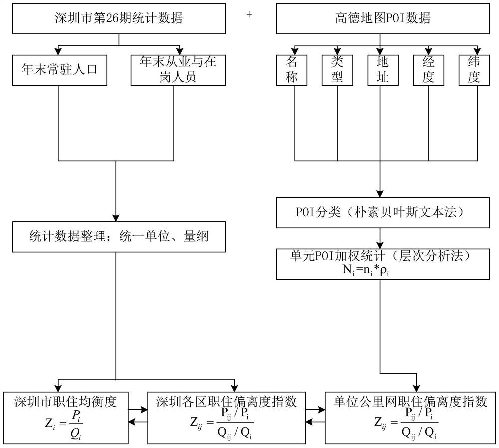
[0041] A method for evaluating occupational and housing space at different scales based on multi-data fusion, including the following steps:

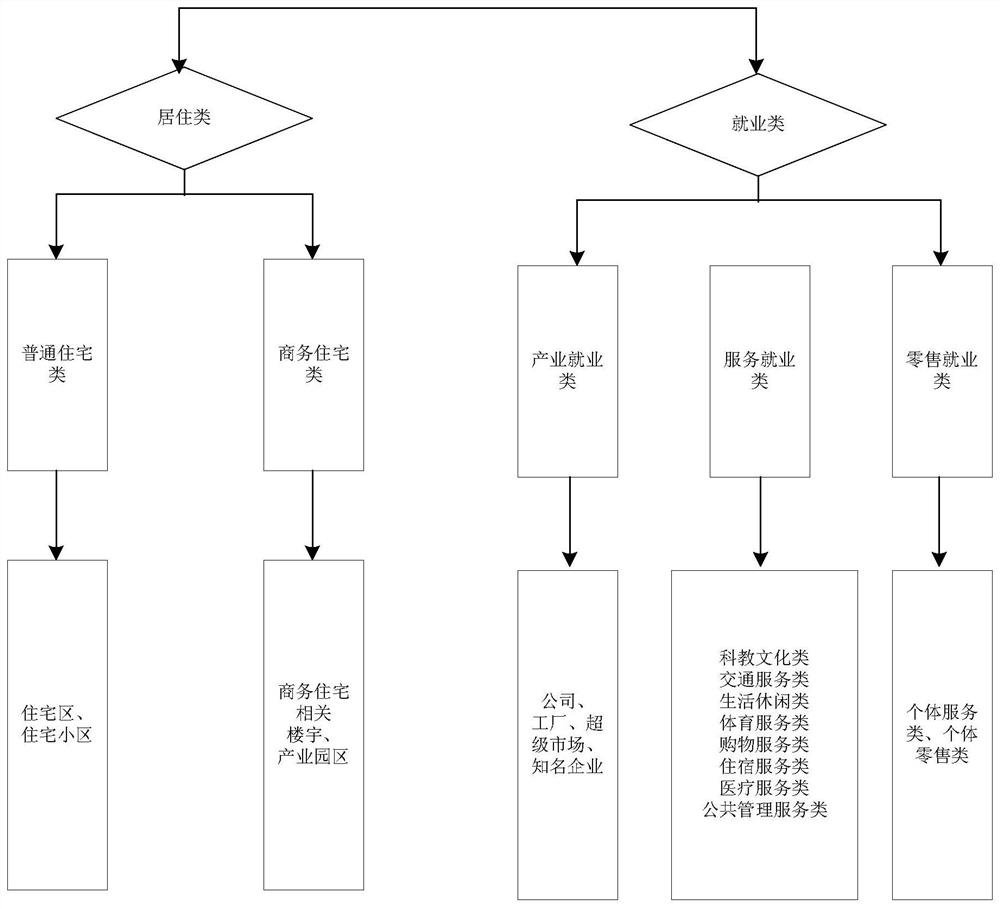
[0042] Step A: Data collection and processing. First of all, through the city statistical yearbook, collect the year-end resident population data and employee data at the city level, and unify the units. Secondly, collect POI data. For example, the POI data of Gaode map can be crawled by crawler software. Each piece of data contains the basic spatial information and attribute information such as the name, category, address, longitude and latitude, and administrative area of ​​the point; then according to the longitude and latitude information of the POI data for visualization.

[0043] Step B: Evaluation of macro-scale occupation and housing space based on traditi...


PUM


Abstract

The invention discloses a method for evaluating occupational and housing space at different scales based on multi-data fusion. At the same level, data processing is carried out separately; different types of POI data are processed by analytic hierarchy process, the weight of POI data of different scales and properties of the same function is distinguished, and evaluation standards for occupational and residential spaces are constructed at different scales. A job-housing space evaluation system at different scales based on multi-data fusion, which includes: a data collection and processing module, and a job-housing deviation index evaluation module. The present invention establishes occupational and residential space evaluation technology at different scales, comprehensively, timely and accurately identifies the spatial distribution of urban occupational and residential areas, provides a more scientific reference for the optimization of urban occupational and residential space and infrastructure layout, and is widely used in urban occupational and residential areas. The field of spatial evaluation.

Description

technical field [0001] The invention relates to the field of occupational and residential space evaluation, in particular to an evaluation method and system for occupational and residential space at different scales based on multi-data fusion. Background technique [0002] With the rapid development of the economy and the continuous advancement of the urbanization process, the scale of the city has a tendency to gradually expand outward. The spatial relationship between the place of residence and the place of employment has evolved from "combination of occupation and residence" to "separation of occupation and residence", and the degree of separation between occupation and residence has intensified. At the same time, the contradiction between residents' growing public service demand and the shortage of public service supply The accessibility and convenience of residents' transportation, entertainment, medical care, and shopping facilities have all declined significantly. Th...

Claims


Application Information

Patent Timeline
Patent Type & Authority Patents(China)
IPC IPC(8): G06Q50/26
CPCG06Q50/26
Inventor 张文晖岳隽陈小祥徐雅莉郜昂李嘉诚汪维录童岩冰
Owner 深圳市数字城市工程研究中心
Why Eureka
Try Eureka