
Intelligent vehicle location method based on prior map

A technology of intelligent vehicles and positioning methods, applied in satellite radio beacon positioning systems, measuring devices, instruments, etc., can solve problems such as affecting positioning accuracy and reducing map accuracy, and achieve the effect of solving low accuracy and overcoming weak GPS signals

Active Publication Date: 2018-11-06
HEFEI INSTITUTES OF PHYSICAL SCIENCE - CHINESE ACAD OF SCI
View PDF7 Cites 33 Cited by
  • Summary
  • Abstract
  • Description
  • Claims
  • Application Information

AI Technical Summary

Problems solved by technology

However, due to the limitation of the computing power of the previous computer, part of the observation information needs to be discarded, resulting in a decrease in the accuracy of the map, which in turn affects the positioning accuracy

Method used


Image

  • Intelligent vehicle location method based on prior map
  • Intelligent vehicle location method based on prior map
  • Intelligent vehicle location method based on prior map

Examples


Embodiment Construction

[0048] In order to further illustrate the features of the present invention, please refer to the following detailed description and accompanying drawings of the present invention. The accompanying drawings are for reference and description only, and are not intended to limit the protection scope of the present invention.

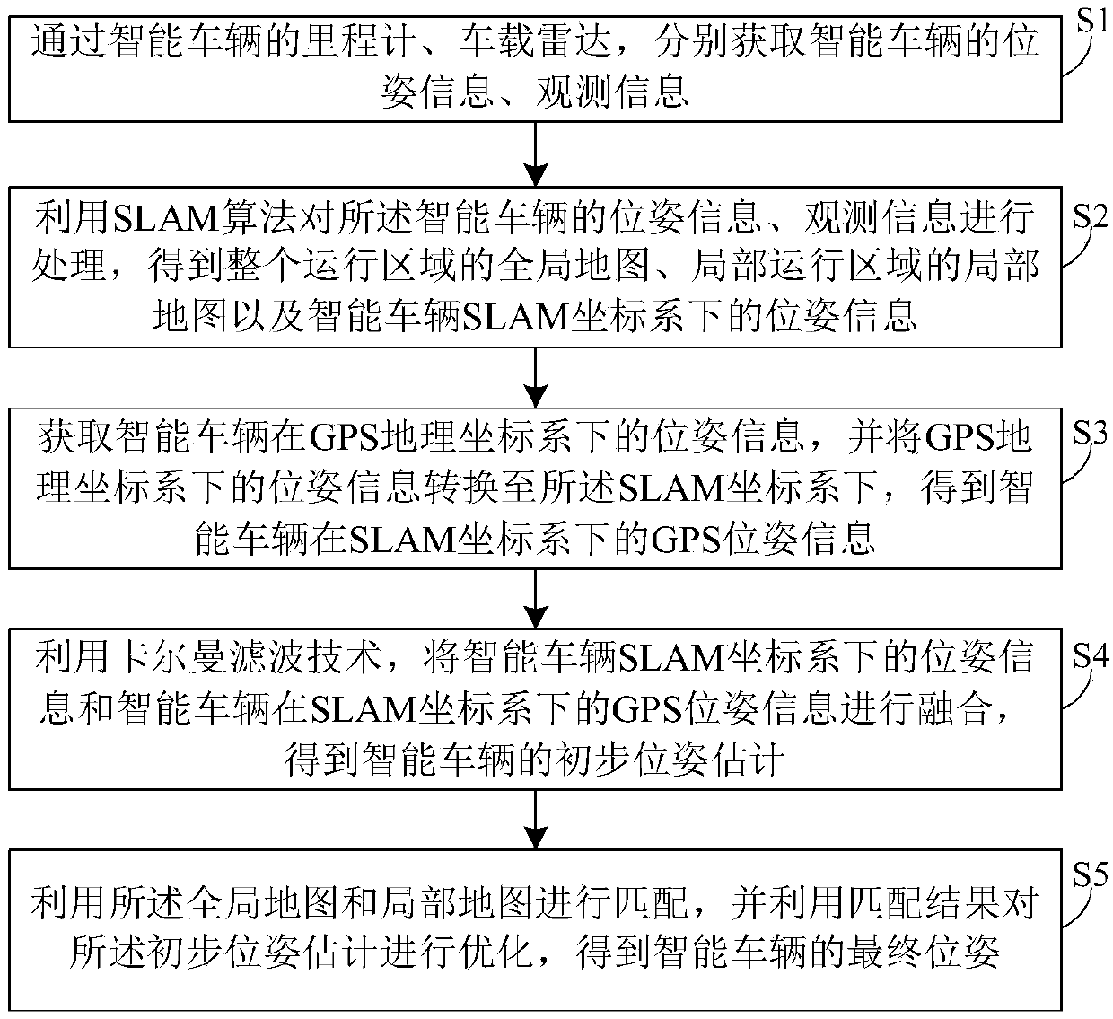
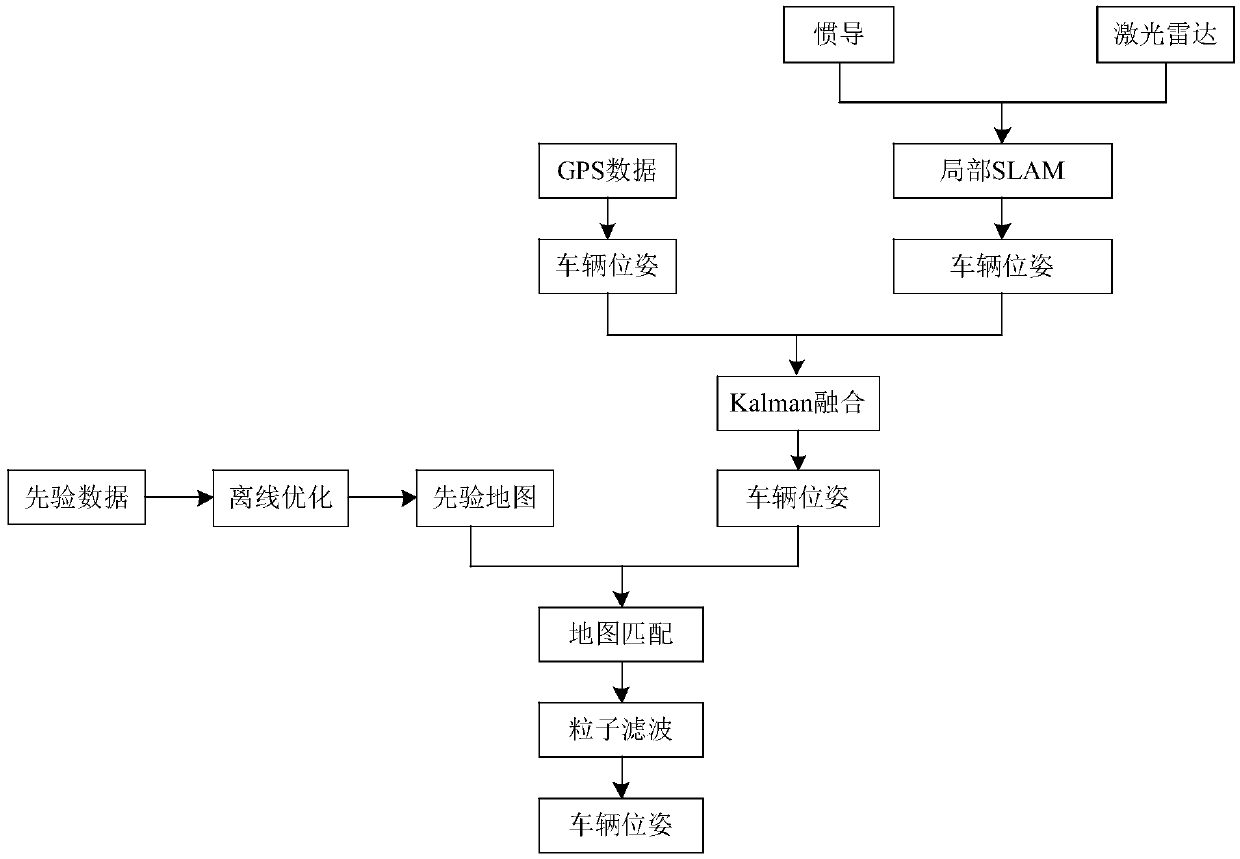
[0049] refer to Figure 1 to Figure 2 As shown, this embodiment discloses a method for positioning a smart vehicle based on a priori map. The smart vehicle moves within a preset operating area. The method includes the following steps:

[0050] S1. Obtain the pose information and observation information of the smart vehicle through the odometer and on-board radar of the smart vehicle respectively. The pose information includes the pose information of the smart vehicle in the entire operating area and the pose information of the local operating area, The observation information includes observation information covering the entire operation area and observatio...


PUM


Abstract

The invention discloses an intelligent vehicle location method based on prior map, including the following steps: 1) by means of an odometer and a vehicle-mounted radar on the intelligent vehicle, respectively acquiring pose information and observation information of the intelligent vehicle; 2) by means of SLAM algorithm, processing the pose information and observation information of the intelligent vehicle to obtain a global map of the whole driving area, a local map of a local driving area, and pose information of the intelligent vehicle under a SLAM coordinate system; 3) acquiring GPS poseinformation of the intelligent vehicle and converting the GPS pose information into the SLAM coordinate system to obtain the GPS pose information of the intelligent vehicle in the SLAM coordinate system; 4) fusing the pose information and the GPS pose information in the SLAM coordinate system through Kalman filtering to obtain initial pose estimation of the intelligent vehicle; 5) matching the global map and the local map, and optimizing the initial pose estimation on the basis of the matched result, thus obtaining final pose of the intelligent vehicle. The method greatly improves precise andaccuracy of a location result of the intelligent vehicle.

Description

technical field [0001] The invention relates to the technical field of intelligent vehicle positioning, in particular to an intelligent vehicle positioning method based on a priori map. Background technique [0002] One of the prerequisites for autonomous driving or assisted driving of intelligent vehicles is to accurately know the position and posture of the vehicle. In the current autonomous driving or assisted driving of intelligent vehicles, positioning methods generally include: positioning based on GPS, positioning based on fusion of GPS and odometer, and synchronous positioning and map widget technology. [0003] Among them, for positioning based on GPS technology, it is susceptible to interference from the external environment, especially the urban environment with many high-rise buildings has great interference on GPS signals, which will lead to large errors in positioning results. [0004] For the positioning method of GPS and odometer fusion, because the vehicle ...

Claims


Application Information

Patent Timeline
IPC IPC(8): G01C21/20G01S19/45
CPCG01C21/20G01S19/45
Inventor 祝辉姜云天余彪梁华为殷若尘陶翔黄健
Owner HEFEI INSTITUTES OF PHYSICAL SCIENCE - CHINESE ACAD OF SCI
Learn More