Outdoor trekking navigation system and method

A navigation system and outdoor technology, applied in the field of navigation systems, can solve problems such as the inability to plan outdoor sports routes, the inability to guarantee complete coverage of the mobile network, and the untimely rescue.

Inactive Publication Date: 2018-11-16
CHENGDU GUOXING COMM
View PDF2 Cites 0 Cited by
  • Summary
  • Abstract
  • Description
  • Claims
  • Application Information

AI Technical Summary

Problems solved by technology

In the existing civil maps on the market, there are still no detailed maps and road displays for outdoor areas, and it is also impossible to plan and navigate outdoor sports routes; moreover, the mobile network cannot guarantee full coverage, and cannot guarantee emergency situations on the way. able to communicate
[0003] Therefore, the safety guarantee ability in outdoor sports needs to be greatly improved, mainly including outdoor enthusiasts who are not familiar with the route and cannot visually view the route on the map; and safety problems caused by insufficient preparation for the complex outdoor environment; and when encountering emergency problems Failure to timely and accurately send distress information and its own location caused the rescue to be delayed

Method used


Image

  • Outdoor trekking navigation system and method
  • Outdoor trekking navigation system and method

Examples


Embodiment Construction

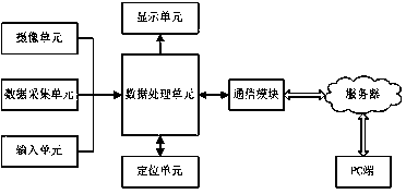
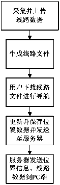
[0024] In order to make the purpose, technical solutions and advantages of the embodiments of the invention more clear, the following will combine the appended figure 1 , clearly and completely describe the technical solutions in the embodiments of the present invention, obviously, the described embodiments are part of the embodiments of the present invention, but not all of the embodiments. usually attached here figure 1 The components of the embodiments of the present invention described and illustrated in may be arranged and designed in a variety of different configurations. Based on the embodiments of the present invention, all other embodiments obtained by persons of ordinary skill in the art without creative efforts fall within the protection scope of the present invention.

[0025] This embodiment provides an outdoor walking navigation system, including a PC terminal, a mobile terminal and a server; the mobile terminal includes an acceleration sensor, a data processor,...


PUM


Abstract

An outdoor trekking navigation system comprises a PC end, a mobile terminal and a server, wherein the mobile terminal comprises a data acquisition unit, a data processing unit, an input unit, a display unit, a camera unit, a communication module and a positioning unit; the data acquisition unit, the input unit, the display unit, the camera unit, the communication module and the positioning unit are connected with the data processing unit respectively; the mobile terminal is connected with the PC end through the server. An outdoor trekking navigation method comprises the following steps: a route database is established; the server generates a route file by using uploaded route data; a user previews and downloads the route file through the mobile terminal, views the file on a map and performs navigation; the positioning unit acquires position information, and the mobile terminal sends the real-time position information to the server through the communication module; the server stores theposition information and sends the position information to the PC end. The problem about route navigation in outdoor sports can be solved, and positioning, emergency communication and rescue on the way are provided.

Description

technical field [0001] The invention belongs to the field of navigation systems, in particular to an outdoor walking navigation system and method. Background technique [0002] Outdoor sports are different from conventional recreational activities. Some high-risk sports require participants to have corresponding experience and life-saving equipment. Especially for outdoor sports such as mountaineering, adventure, and rafting, which outdoor enthusiasts are most yearning for, the risk factor is relatively high. Outdoor sports are often carried out in remote areas with few people, and the routes and roads are extremely complicated (such as cliffs, rivers, valleys, etc.). In the existing civilian maps on the market, there are still no detailed maps and road displays for outdoor areas, and it is also impossible to plan and navigate outdoor sports routes; moreover, the mobile network cannot guarantee full coverage, and cannot guarantee emergency situations on the way. able to co...

Claims


Application Information

Patent Timeline
IPC IPC(8): G01C21/00G01S19/42
CPCG01C21/00G01S19/42
Inventor 王桐唐裕峰
Owner CHENGDU GUOXING COMM
Why Eureka
Try Eureka