Indoor positioning and navigation method based on grid beacon and building information model

A building information model and indoor positioning technology, applied in the field of indoor positioning and navigation, can solve problems such as difficult signal processing, mobile phone sensors may not meet the requirements, angle errors, etc., achieve fast association retrieval, fast perception and efficient calculation, low cost effect

Inactive Publication Date: 2020-06-09
北京北斗伏羲科技有限公司
View PDF11 Cites 2 Cited by
  • Summary
  • Abstract
  • Description
  • Claims
  • Application Information

AI Technical Summary

Problems solved by technology

[0009] 1) It is difficult to achieve positioning accuracy: various positioning algorithms have their own defects. For ordinary equipment, some parameters are difficult to obtain; at the same time, due to the large coverage of the base station, the angle will cause certain errors, and the positioning accuracy cannot be guaranteed.
[0010] 2) Signal processing is difficult: Due to the sensitivity of the angle, the sensor of the mobile phone may not meet the requirements, the problem of signal blocking inside the building is relatively large, and there is no better solution for navigation between different floors
[0011] 3) Indoor positioning requires the deployment of a signal network and the determination of the location of the signal source, all of which require cost, especially in large shopping malls, where the cost increases significantly

Method used


Image

  • Indoor positioning and navigation method based on grid beacon and building information model
  • Indoor positioning and navigation method based on grid beacon and building information model
  • Indoor positioning and navigation method based on grid beacon and building information model

Examples


Embodiment 1

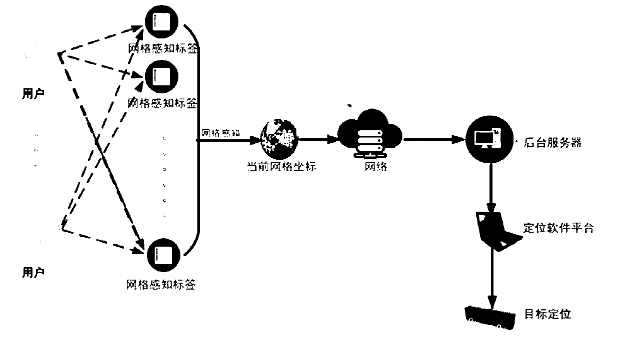
[0048] see figure 1 , which is a schematic diagram of an indoor positioning and navigation method based on grid beacons and building information models provided in this embodiment. The indoor positioning and navigation method shown includes the following steps:

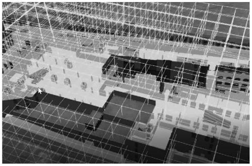
[0049] S1: Based on Beidou network coding technology and building information model, build a building three-dimensional grid model for the building to be tested, such as figure 2 shown.

[0050]It should be noted that the core of Building Information Modeling (Building Information Modeling, BIM) is to provide a complete and consistent construction engineering information library for this model by establishing a virtual three-dimensional model of construction engineering and using digital technology. The information base not only contains geometric information, professional attributes and state information describing building components, but also contains state information of non-component objects (such as space and ...

Embodiment 2

[0066] In addition to using paper grid beacons to achieve indoor positioning and navigation, electronic label technology can also be used. An indoor positioning and navigation method based on grid beacons and building information models, comprising the following steps:

[0067] S1: Based on Beidou network coding technology and building information model, build a building three-dimensional grid model for the building to be tested.

[0068] S2: Assign different spatial codes to each unit grid of the architectural three-dimensional grid model.

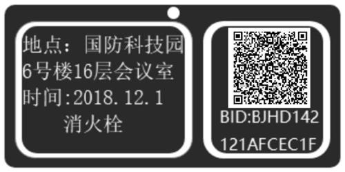
[0069] S3: After obtaining the item codes corresponding to each component in the building three-dimensional grid model based on the national item coding system, construct a spatial code-item code association table and an item code-part name association table.

[0070] Such as Figure 4 As shown, 4723 is the spatial code of the unit grid. In the national article coding system, 101 is the code of the door, then 4723-101 constitutes the sp...


PUM


Abstract

The invention provides an indoor positioning and navigation method based on a grid beacon and a building information model, and the method comprises the steps: deploying a paper grid beacon or an RFIDtag in a building based on a building three-dimensional grid code, and achieving the correlation between building internal information data and unit grids; meanwhile, traffic capacity quantificationis carried out on each unit grid in the building three-dimensional grid model, a gridding path efficient calculation model is constructed, the starting point position of the user is determined throughthe paper grid beacon, and indoor navigation path calculation can be carried out according to the terminal point position received by the terminal.

Description

technical field [0001] The invention belongs to the technical field of electronic information, and in particular relates to an indoor positioning and navigation method based on a grid beacon and a building information model. Background technique [0002] Existing indoor positioning and navigation methods mainly include Bluetooth indoor navigation system, Wi-Fi indoor positioning technology, ultra-wideband indoor positioning technology, RFID indoor positioning technology and ultrasonic technology. Among them, for the Bluetooth indoor navigation system, by implanting the map drawn in advance into the mobile device, the current location of the mobile device is calculated through the Bluetooth signal, and the navigation from any guide point to various indoor areas is realized through the combination of the Bluetooth base station data and the map; Specifically, it is generally divided into the following steps: [0003] a) Map drawing: map the interior of the target building, and...

Claims


Application Information

Patent Timeline
Patent Type & Authority Applications(China)
IPC IPC(8): G01C21/00H04W4/02H04W4/024H04W4/33H04W64/00
CPCG01C21/005H04W4/023H04W64/006H04W4/024H04W4/33
Inventor 秦劲松任伏虎张亚强袁亮
Owner 北京北斗伏羲科技有限公司
Why Eureka
Try Eureka