Building area extraction method and system based on SAR image

An extraction method and technology of building areas, applied in the field of remote sensing, can solve the problem of not being able to obtain the distribution of building areas

Active Publication Date: 2018-11-16
AEROSPACE INFORMATION RES INST CAS
View PDF4 Cites 4 Cited by
  • Summary
  • Abstract
  • Description
  • Claims
  • Application Information

AI Technical Summary

Problems solved by technology

However, these methods only rely on the intensity information of the image. For example, for a low-resolution SAR image such as 75m, the settlement information can be accurately obtained, but for a medium-resolution wide SAR image (such as

Method used


Image

  • Building area extraction method and system based on SAR image
  • Building area extraction method and system based on SAR image
  • Building area extraction method and system based on SAR image

Examples


Embodiment Construction

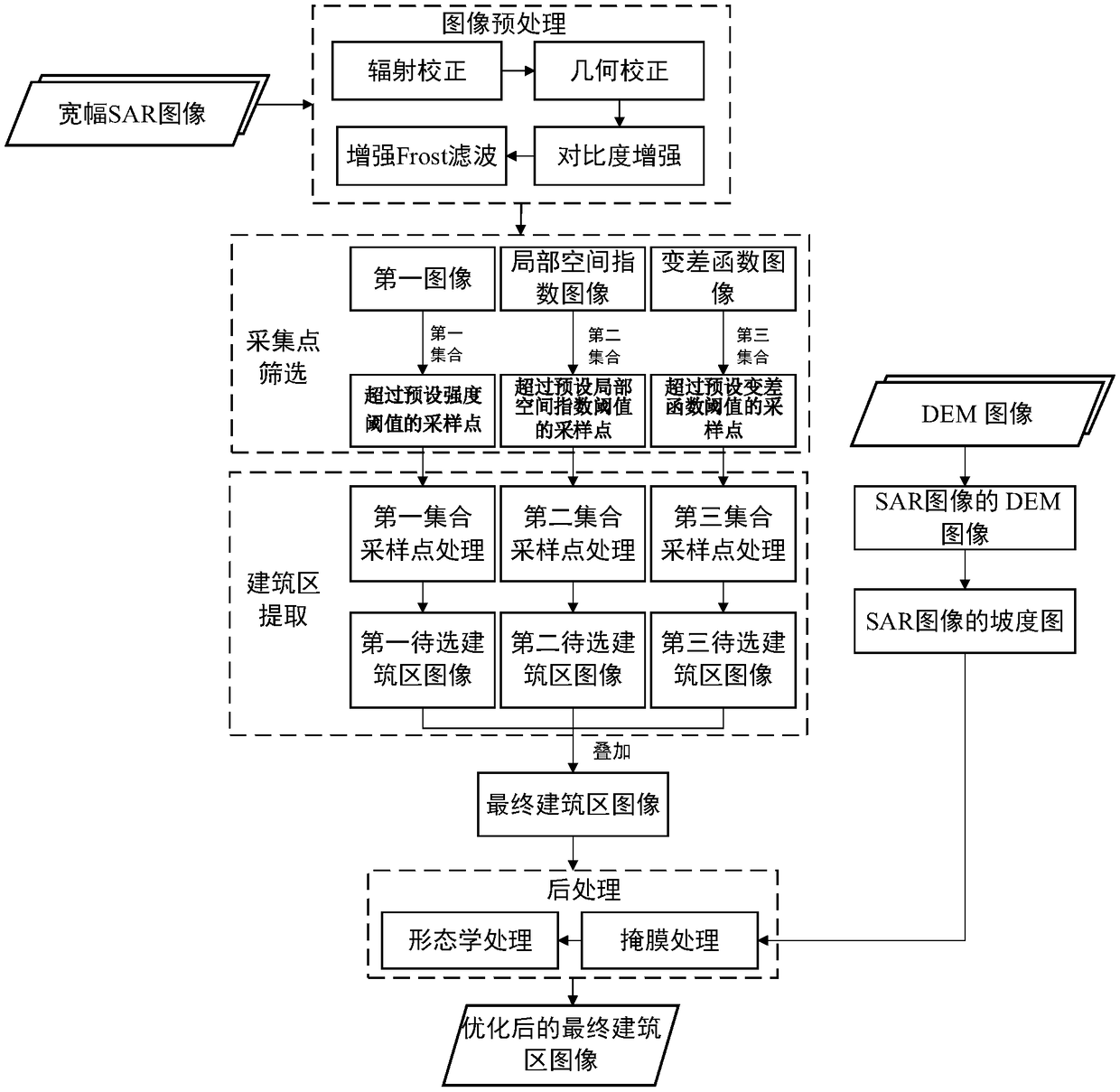
[0054] Hereinafter, specific embodiments of the present invention will be described in detail with reference to the accompanying drawings, but it is not a limitation of the present invention.

[0055] It should be understood that various modifications can be made to the embodiments disclosed herein. Therefore, the above description should not be regarded as a limitation, but merely as an example of an embodiment. Those skilled in the art will think of other modifications within the scope and spirit of this disclosure.

[0056] The drawings included in the specification and constituting a part of the specification illustrate the embodiments of the present disclosure, and are used to explain the present disclosure together with the general description of the present disclosure given above and the detailed description of the embodiments given below principle.

[0057] These and other characteristics of the present invention will become apparent from the following description of prefer...


PUM


Abstract

The invention provides a building area extraction method and system based on an SAR image. The building area extraction method based on the SAR image includes: acquiring a first image on the basis ofthe SAR image; generating a local space index image and a variogram image on the basis of the first image; respectively screening sampling points on the basis of the local space index image, the variogram image and the first image to obtain corresponding sets; and processing sampling points in each set according to preset growth criteria to respectively construct to-be-selected building area images, superimposing all the to-be-selected building area images to obtain a final building area image. Through the method or the system provided by the invention, a building area can be quickly and accurately extracted from the Sentinel-1 SAR image, automatic extraction of construction land of a large region is realized, and a foundation is laid for global building area mapping.

Description

Technical field [0001] This application relates to the field of remote sensing, in particular to a method and system for extracting building areas based on SAR images. Background technique [0002] Studies have shown that 66% of the world’s population will live in urban areas by 2050. Although urban areas only account for a small part of the world's land, because they are gathering places for transportation and energy consumption, they affect the ecological environment to a large extent. Therefore, accurate and timely acquisition of building land information is of great significance to urban planning and post-earthquake disaster relief. [0003] Optical remote sensing satellites provide a valuable source of data for the extraction of construction land. However, compared with optical sensors, radar systems have the characteristics of all-weather observation and imaging all the time. Therefore, for areas covered by clouds and fog all year round, the radar system SAR data has a wide...

Claims


Application Information

Patent Timeline
IPC IPC(8): G06K9/00G06K9/46G06T7/00G06T7/11G06T7/136
CPCG06T7/00G06T7/11G06T7/136G06T2207/10044G06V20/176G06V10/44
Inventor 张红曹菡王超
Owner AEROSPACE INFORMATION RES INST CAS
Why Eureka
Try Eureka