Improved high-resolution remote sensing image classification method based on deep learning

A remote sensing image and deep learning technology, applied in the field of image processing, can solve the problems of complex feature extraction process, redundancy, poor displacement and rotation, etc.

Active Publication Date: 2018-11-16
HOHAI UNIV
View PDF6 Cites 55 Cited by
  • Summary
  • Abstract
  • Description
  • Claims
  • Application Information

AI Technical Summary

Problems solved by technology

[0009] (1) The existing remote sensing image classification methods often require remote sensing image samples to be preprocessed, and the preprocessing process is easily affected by many external factors, such as atmospheric conditions, surface environment and other factors, which will weaken the classification performance
[0010] (2) Existing remote sensing image classification methods require too much human intervention when extracting features. Different image feature extraction algorithms are selected to extract v

Method used


Image

  • Improved high-resolution remote sensing image classification method based on deep learning
  • Improved high-resolution remote sensing image classification method based on deep learning
  • Improved high-resolution remote sensing image classification method based on deep learning

Examples


Embodiment Construction

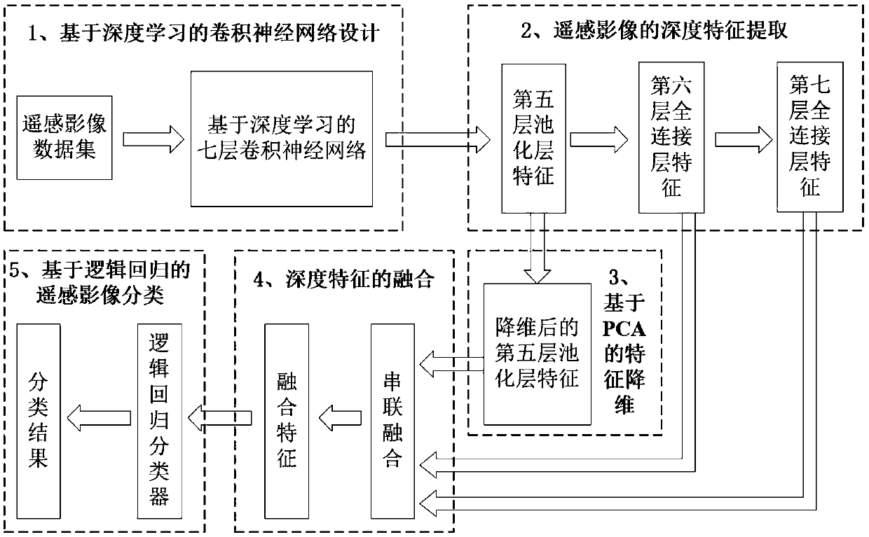
[0086] The technical solutions of the present invention will be further described below in conjunction with the accompanying drawings and embodiments.

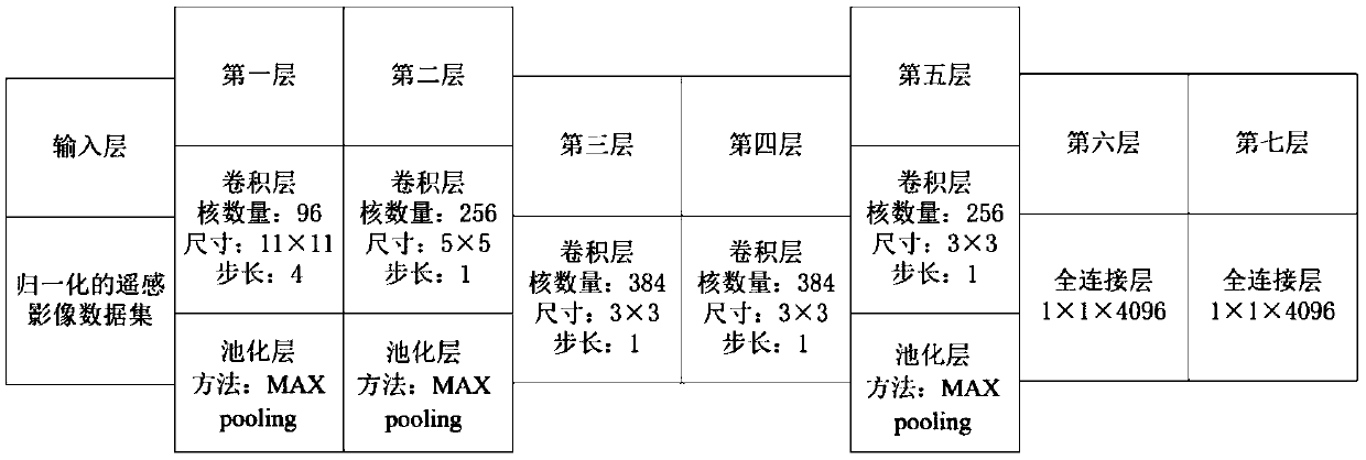
[0087] Such as figure 1 As shown, a further detailed description is as follows:

[0088] (1) Construct multi-category remote sensing image sample data sets, and make corresponding sample label sets, and divide remote sensing image sample data sets into training set Train and test set Test.

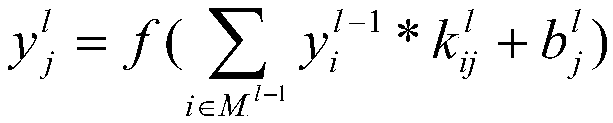
[0089] (1.1) Construct multi-category remote sensing image sample dataset Image=[Image 1 ,...,Image i ,...,Image N ], and make the corresponding sample label Label=[Label 1 ,...,Label i ,...,Label N ], where N represents N types of remote sensing images, Image i Indicates the set of i-th remote sensing images, Label i Represents the label set of the i-th category of remote sensing images, and the value of each category label is i. The present invention selects UCMerced_LandUse, a public data set of remote sensing scene images, for...


PUM


Abstract

The invention discloses an improved high-resolution remote sensing image classification method based on deep learning. On the basis of the deep learning theory, a seven-layer convolutional neural network is designed; a high-resolution remote sensing image sample is inputted into the network to carry out network training and last two full connection layers obtained by learning are outputted as twodifferent high-level features of the remote sensing image; dimension reduction is carried out by using a principal component analysis for the output of the fifth pooling layer of the network, whereinthe result after dimension reduction is used as a third high-level feature of the remote sensing image; the three kinds of high-level features are fused in series; and then an effective logistic-regression-based classifier is designed to classify the remote sensing image. According to the invention, feature extraction is carried out on the high-resolution remote sensing image based on the deep learning theory and the features obtained by learning have high expressive force and robustness. Besides, the extracted high-level features are fused and the fused feature is inputted into the logistic regression classifier, so that the good classification result is obtained.

Description

technical field [0001] The invention belongs to the field of image processing, and in particular relates to an improved classification method of high-resolution remote sensing images based on deep learning. Background technique [0002] In the field of optical remote sensing image processing, the spatial resolution of remote sensing images refers to the minimum size of a single feature or two adjacent features that can be identified by optical sensors. The higher the spatial resolution, the richer the morphological information of ground features contained in remote sensing images. The spatial resolution of optical remote sensing satellites currently in commercial operation has reached the "sub-meter level". For example, the US WorldView-4 satellite launched in 2016 can provide high-definition ground images with a resolution of 0.3m. In recent years, with the rapid development of my country's space technology, especially the implementation of major projects of high-spatial-r...

Claims


Application Information

Patent Timeline
IPC IPC(8): G06K9/62G06N3/04
CPCG06N3/045G06F18/2148G06F18/241
Inventor 王鑫李可石爱业
Owner HOHAI UNIV
Why Eureka
Try Eureka