Generation system and method for live-action map

A technology for generating systems and real-life maps, applied in the field of geographic information systems, can solve the problems of inability to accurately and timely reflect the actual situation, unfavorable data analysis, etc., to achieve the effect of convenient data analysis and promotion and application

Active Publication Date: 2018-11-20
CHENGDU SHANHE SPATIAL INFORMATION TECH CO LTD
View PDF8 Cites 7 Cited by
  • Summary
  • Abstract
  • Description
  • Claims
  • Application Information

AI Technical Summary

Problems solved by technology

However, there is currently no solution that can combine real-scene images with maps. In most application scenarios, real-scene images and maps are displayed separately, which makes it impossible to accurately and timely reflect the actual situation, which is not conducive to data analysis.

Method used


Image

  • Generation system and method for live-action map
  • Generation system and method for live-action map
  • Generation system and method for live-action map

Examples


Embodiment Construction

[0038] All features disclosed in this specification, or steps in all methods or processes disclosed, may be combined in any manner, except for mutually exclusive features and / or steps.

[0039] Any feature disclosed in this specification (including any appended claims, abstract), unless otherwise stated, may be replaced by alternative features which are equivalent or serve a similar purpose. That is, unless expressly stated otherwise, each feature is one example only of a series of equivalent or similar features.

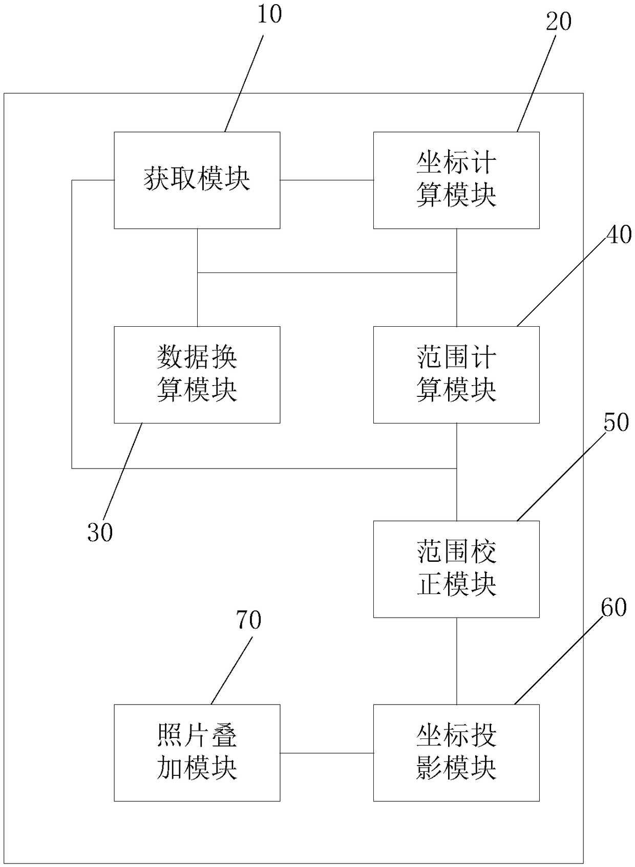
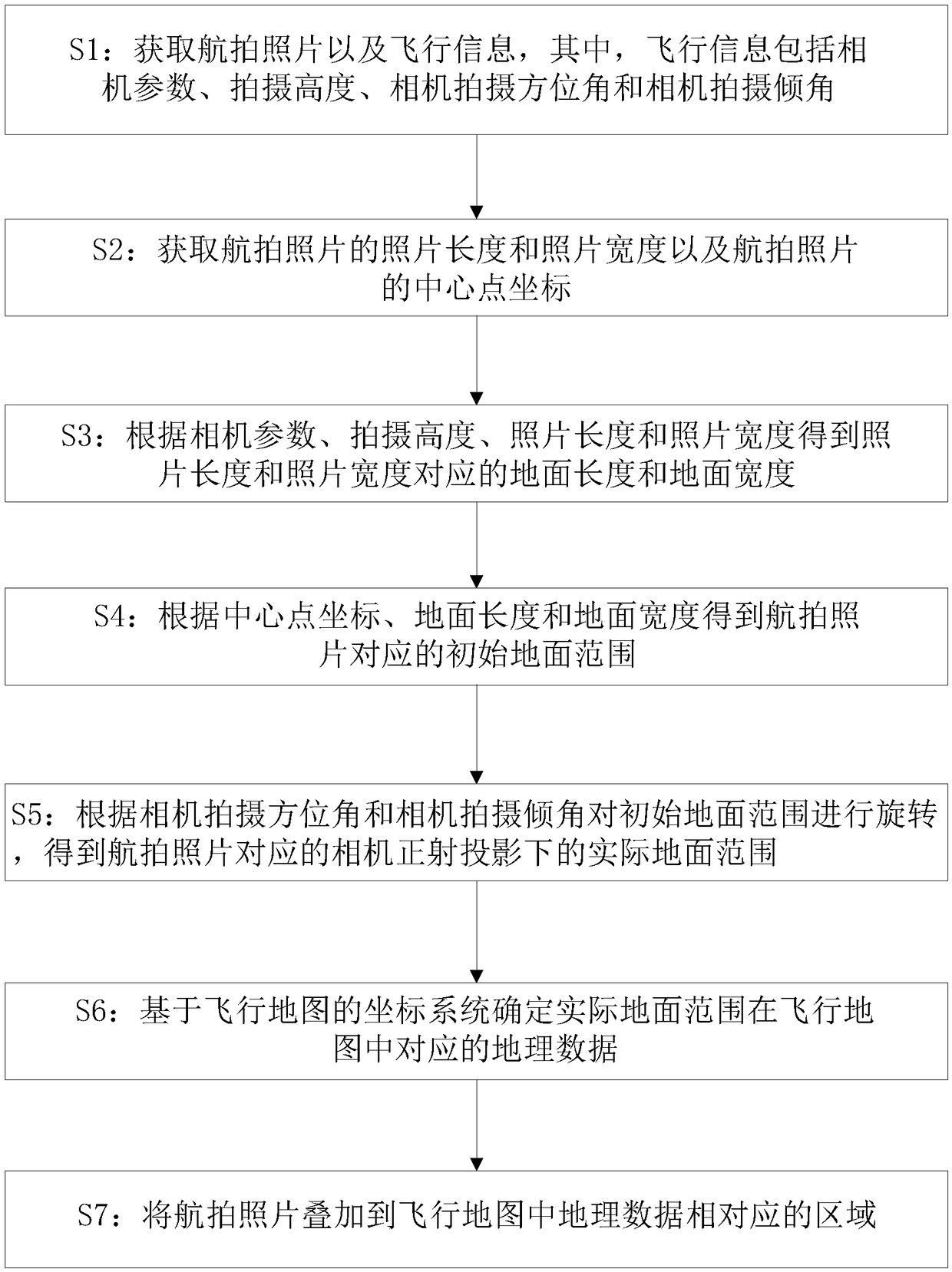
[0040] Such as figure 1 As shown, in the embodiment of the present invention, the generation system of the real scene map includes an acquisition module 10, a coordinate calculation module 20, a data conversion module 30, a range calculation module 40, a range correction module 50, a coordinate projection module 60 and a photo overlay module 70.

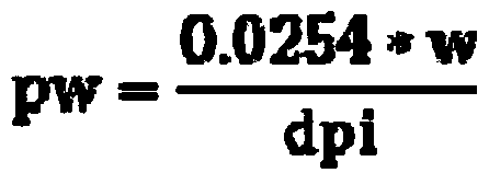
[0041] The acquiring module 10 is used to acquire aerial photos and flight information, wherein the flight information ...


PUM


Abstract

The invention discloses a generation system and method for a live-action map. The system comprises an acquisition module, a coordinate calculation module, a data conversion module, a range calculationmodule, a range correction module, a coordinate projection module and a photo overlapping module, wherein the acquisition module is used for obtaining an aerial photography photo and flight information; the coordinate calculation module is used for obtaining the photo length and the photo width of the aerial photography photo and the center point coordinates of the aerial photography photo; the data conversion module is used for obtaining ground length and ground width according to camera parameters, photographing height, photo length and photo width; the range calculation module is used forobtaining an initial ground range according to the center point coordinates, the ground length and the ground width; the range correction module is used for rotating the initial ground range to obtaina practical ground range under the orthographic projection of a camera; the coordinate projection module is used for determining the corresponding geographic data of the practical ground range in a flight map on the basis of the coordinate system of the flight map; and the photo overlapping module is used for overlapping the aerial photography photo to an area corresponding to the geographic datain the flight map. By use of the system, a live-action image and the map can be combined so as to bring convenience in data analysis.

Description

technical field [0001] The invention relates to the technical field of geographic information systems, in particular to a system and method for generating a real scene map. Background technique [0002] Map is an important geographic information tool, which is used in almost all walks of life. However, for some special industries, such as land, forestry, water affairs, rescue and other industries, it is necessary to display real-time images of the target area in real time to facilitate the arrangement and development of work. However, there is currently no solution that can combine real-scene images and maps. In most application scenarios, real-scene images and maps are displayed separately, resulting in the inability to accurately and timely reflect the actual situation, which is not conducive to data analysis. Contents of the invention [0003] The object of the present invention is to provide a method for generating a real-scene map in view of the above-mentioned probl...

Claims


Application Information

Patent Timeline
Patent Type & Authority Applications(China)
IPC IPC(8): G06F17/30G01C11/00
CPCG01C11/00
Inventor 欧阳鹏黄宇
Owner CHENGDU SHANHE SPATIAL INFORMATION TECH CO LTD
Why Eureka
Try Eureka