Road monitoring method and system based on vehicle navigation

A vehicle navigation and monitoring system technology, applied in the field of traffic management, can solve the problems of inability to call mobile phones, damage, untimely response, etc., to reduce the amount of data processing, improve transmission efficiency, and reduce manual operations.

Inactive Publication Date: 2018-11-30
泉州创先力智能科技有限公司
View PDF5 Cites 9 Cited by
  • Summary
  • Abstract
  • Description
  • Claims
  • Application Information

AI Technical Summary

Problems solved by technology

[0004] Recently, there are many important road sections that have provided real-time network traffic picture or speed parameters for statistical analysis, but when the car owner starts, if there is a variable, the car owner cannot know it in real time. Even if there is a lot of information to understand the road condition, if there is no Classification, car owners still need to spend a lot of time to see some useful road conditions, or car owners can use mobile phones to know road conditions and provide road conditions to radio stations and other units, but it is currently stipulated that driving cannot make mobile phones
In addition, many road sections are seriously damaged, the response is not timely, and they cannot be repaired all the year round, which seriously affects road traffic.

Method used


Image

  • Road monitoring method and system based on vehicle navigation
  • Road monitoring method and system based on vehicle navigation
  • Road monitoring method and system based on vehicle navigation

Examples


no. 1 example

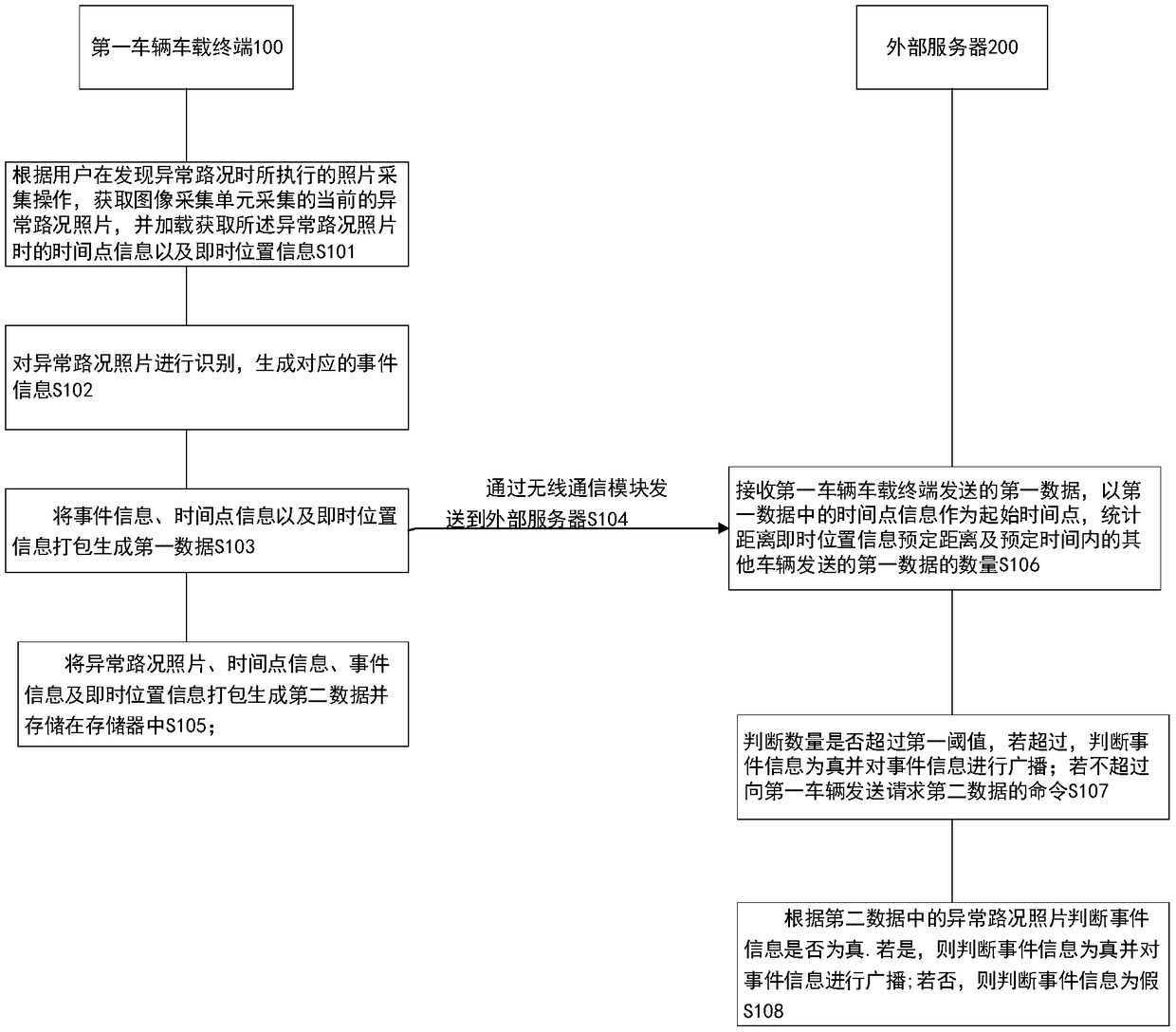
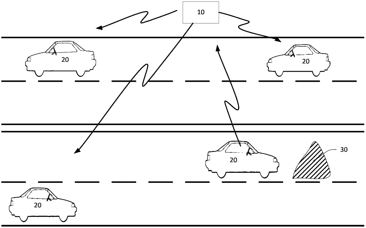
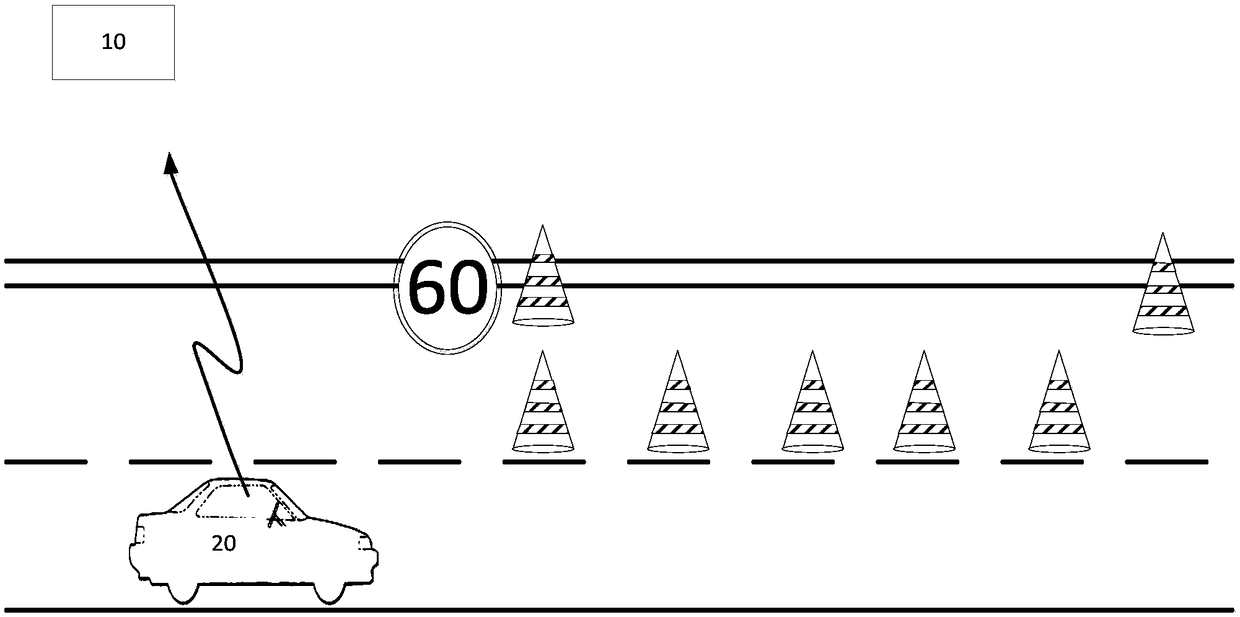
[0057] see Figure 1 to Figure 3 , figure 1 It is a schematic flow chart of the road monitoring method based on vehicle navigation provided by the first embodiment of the present invention, figure 2 It is a schematic diagram of a road monitoring device based on vehicle navigation provided by an embodiment of the present invention, image 3 It is a schematic diagram of road monitoring event information based on vehicle navigation provided by an embodiment of the present invention. The present invention sends different abnormal road condition information to the road management department, the traffic control department and other vehicles passing through the lane. On the one hand, it can be used as a reference for the owners of other vehicles, so that the owners can avoid road obstructions and save energy in the shortest time and with the least fuel consumption. On the other hand, sending abnormal road conditions to the road management department and the traffic control depart...

no. 2 example

[0086] On the basis of the first embodiment, refer to Figure 4 . Figure 4A schematic structural diagram of a vehicle navigation-based road monitoring device according to a second embodiment is provided for the present invention.

[0087] The second embodiment of the present invention provides a road monitoring device based on vehicle navigation, which specifically includes:

[0088] The first vehicle-mounted terminal 100 is used to acquire the current abnormal road condition photo collected by the image acquisition unit according to the photo collection operation performed by the user when the abnormal road condition is found, and load the time point information and real-time location information.

[0089] Identify photos of abnormal road conditions and generate corresponding event information.

[0090] Pack event information, time point information, and instant location information to generate first data and send it to an external server through a wireless communication ...


PUM


Abstract

The embodiment of the invention discloses a road monitoring method and device based on vehicle navigation. The road monitoring method comprises the steps that an abnormal road condition photo, time point information and real-time location information are acquired by a first vehicle on-board terminal; the photo is identified to generate corresponding event information; the event information, the time point information and the real-time location information are packed to generate first data and sent to an external server, and at the same time, the abnormal road condition photo and the first dataare packed to generate second data and stored in a memory; the external server receives the first data, and uses the time point information in the first data as a starting time point, and the numberof the first data sent by other vehicles with a predetermined distance to the real-time location information and in the predetermined time are calculated; if the number exceeds a first threshold, it is determined that the event information is true and the event information is broadcasted; if the number does not exceed the first threshold, whether the event information is true or not is determinedaccording to the abnormal road condition photo in the second data; and if yes, the event information is true and broadcasted.

Description

technical field [0001] The invention relates to the technical field of traffic management, in particular to a road monitoring method and system based on vehicle navigation. Background technique [0002] With the progress of the society, the rapid development of the economy, the improvement of people's living standards, the acceleration of industrialization and urbanization has promoted the arrival of the automobile era, and in recent years, the mileage of roads in my country has increased by more than 20% per year, especially in urban roads and expressways. The update speed is very fast, and at the same time, the blowout development of the private car market. [0003] At present, car owners usually listen to AM / FM broadcasts to understand road conditions when they drive out. However, because the range of AM / FM broadcasts is not certain and the signal is often interfered by factors such as high mountain barriers, it is not impossible for car owners to hear the above-mentioned ...

Claims


Application Information

Patent Timeline
Patent Type & Authority Applications(China)
IPC IPC(8): G08G1/0967
CPCG08G1/096775
Inventor 李旺龙
Owner 泉州创先力智能科技有限公司
Why Eureka
Try Eureka